
Lima District
Encyclopedia
Lima is a district
of the Lima Province
in Peru
. It is not where the inner city
zone of Lima
, the country's capital city, is located, San Isidro District being such area in Lima.
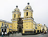
This district is the oldest in Lima and as such, vestiges of the city's colonial
era remain today in the Historic centre of Lima
, which was declared a UNESCO World Heritage Site in 1988.
Currently, the mayor
(alcaldesa) of the Lima District is Susana Villarán
and its postal code
is 1.
of 21.98 km². Its administrative center is located at 154 meters above sea level
.
 According to a 2005 estimate by the INEI
, the district has 278,804 inhabitants and a population density of 15,736.9 persons/km². In 1999, there were 75,595 households in the district.
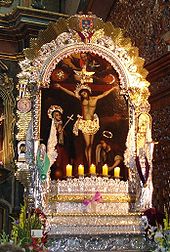
The high point of Lima's religious calendar for the masses is a month of festivities in October dedicated to the Lord of Miracles
, during which take place several processions in the city.
 Central Lima (known as Cercado proper) is limited by Avenida Alfonso Ugarte on the west and Jirón Huánuco (Huánuco Street) on the east. It is divided into West and East sides by Jirón de la Unión (Union Street), from which cuadras (blocks
) are numbered beginning at 100 and changing the first numbers at the next block. Unlike New York's
Fifth Avenue, though, Jirón de la Unión is not paved for cars, but almost entirely a shopping and pedestrian street; the main thoroughfares for cars and bus
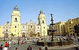
es are Tacna Ave. on the West side and Abancay Ave. on the East. Both are separated from Jirón de la Unión by 4 blocks. The Plaza de Armas
(Grand Army Plaza), which is the main square, is located on block 2 of Jirón de la Unión, facing the Peruvian government palace and the Metropolitan Municipality of Lima (City Hall
).
East of the center is the Barrios Altos (Uptown) neighborhood. Here the oldest, though least stable, buildings in Central Lima are located. Two cemeteries, El Angel and Presbítero Maestro, form the eastern border with El Agustino
. Parts of the long-demolished colonial city walls can be seen here.
 South of the West Side is Santa Beatriz section, which contains residential buildings and the Parque de la Reserva. Santa Beatriz is locally famous for containing the buildings for the state TV network TNP
(Ch. 7), and the top two private TV networks, America Television (Ch. 4) and Panamericana Television (Ch. 5). Its main thoroughfare is Arequipa Avenue, a narrow boulevard lined with trees of all sizes. Santa Beatriz is also home to the city (and country)'s main football stadium
, the Estadio Nacional
(National Stadium).
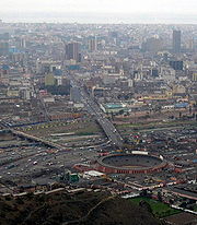
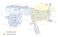 West of the center is the Industrial Area, an industrial
belt extending into neighboring Callao Region, and home to the main industries in both city and country. Most of the area is covered by large blocks containing large factories.
At its northern and southern edges, there are clusters of residential area
s, particularly in the southern zone bordering Pueblo Libre, San Miguel
and Callao Region's Bellavista District
.
Districts of Peru
The districts of Peru are the third-level country subdivisions of Peru. They are subdivisions of the provinces, which in turn are subdivisions of the larger regions or departments...
of the Lima Province
Lima Province
Lima Province is located in the central coast of Peru and is the only province in the country not belonging to any of the twenty-five regions. Its capital is Lima, which is also the nation's capital....
in Peru
Peru
Peru , officially the Republic of Peru , is a country in western South America. It is bordered on the north by Ecuador and Colombia, on the east by Brazil, on the southeast by Bolivia, on the south by Chile, and on the west by the Pacific Ocean....
. It is not where the inner city
Central business district
A central business district is the commercial and often geographic heart of a city. In North America this part of a city is commonly referred to as "downtown" or "city center"...
zone of Lima
Lima
Lima is the capital and the largest city of Peru. It is located in the valleys of the Chillón, Rímac and Lurín rivers, in the central part of the country, on a desert coast overlooking the Pacific Ocean. Together with the seaport of Callao, it forms a contiguous urban area known as the Lima...
, the country's capital city, is located, San Isidro District being such area in Lima.
This district is the oldest in Lima and as such, vestiges of the city's colonial
Colonialism
Colonialism is the establishment, maintenance, acquisition and expansion of colonies in one territory by people from another territory. It is a process whereby the metropole claims sovereignty over the colony and the social structure, government, and economics of the colony are changed by...
era remain today in the Historic centre of Lima
Historic centre of Lima
Located principally in the city centre or Cercado de Lima and Rímac areas, the Historic Centre of Lima is among the most important tourist destinations in Peru.-Foundation:...
, which was declared a UNESCO World Heritage Site in 1988.
Currently, the mayor
Mayor
In many countries, a Mayor is the highest ranking officer in the municipal government of a town or a large urban city....
(alcaldesa) of the Lima District is Susana Villarán
Susana Villarán
Susana María del Carmen Villarán de la Puente is a centre-left politician in Peru, a former presidential candidate, and in municipal elections in 2010 became the first woman to be elected Mayor of Lima....
and its postal code
Postal code
A postal code is a series of letters and/or digits appended to a postal address for the purpose of sorting mail. Once postal codes were introduced, other applications became possible.In February 2005, 117 of the 190 member countries of the Universal Postal Union had postal code systems...
is 1.
Geography
The district has a total land areaArea
Area is a quantity that expresses the extent of a two-dimensional surface or shape in the plane. Area can be understood as the amount of material with a given thickness that would be necessary to fashion a model of the shape, or the amount of paint necessary to cover the surface with a single coat...
of 21.98 km². Its administrative center is located at 154 meters above sea level
Sea level
Mean sea level is a measure of the average height of the ocean's surface ; used as a standard in reckoning land elevation...
.
Boundaries
- North: The Rímac RiverRímac RiverThe Rímac River is located in western Peru and is the most important source of potable water for the Lima and Callao Metropolitan Area.The river is part of the Pacific watershed and has a length of 160 km...
marks the district's border with the San Martín de PorresSan Martín de PorresSan Martín de Porres is a district in Lima, Peru, located in the area known as Cono Norte. It is bordered by the district of Callao on the west; Los Olivos on the northeast; and the Rímac and Independencia districts on the east...
and RímacRímac DistrictRímac is a district in the Lima Province, Peru. It lies directly to the north of downtown Lima, to which it is connected by six bridges over the Rímac River. The district also borders the Independencia, San Martín de Porres, and San Juan de Lurigancho districts...
districts. - East: El AgustinoEl AgustinoEl Agustino is a district of the Lima Province in Peru. It is part of city of Lima.Officially established as a district on January 6, 1965, the current mayor of El Agustino is Víctor Modesto Salcedo Ríos. The district's postal code is 10....
- South: La Victoria, LinceLinceLince is a district of the Lima Province in Peru. It is part of the city of Lima.Officially established as a district on May 29, 1936, the current mayor of Lince is Fortunato Príncipe, and the first one was Juan R. Velásquez. The district's postal code is 14.-Geography:The district has a total...
, Jesús María, BreñaBreñaBreña is a district of the Lima Province in Peru. It is part of Lima city metropolitan area.Officially established as a district on July 15, 1949, the current mayor of Breña is José Gordillo Abad. The district's postal code is LIM05. If you live in the USA and want to send a letter, gift etc to a...
and Pueblo LibrePueblo LibrePueblo Libre is a district of the Lima Province in Peru and one of the districts that comprise the city of Lima. Its name, which means Free Town or Free People, was granted by José de San Martín on April 10, 1822 as a recognition of the patriotism shown by its inhabitants during the Peruvian War of...
. - West: San Miguel DistrictSan Miguel District, LimaSan Miguel, is a district in western Lima, Peru. It is bordered by the districts of Bellavista and downtown Lima on the north; Pueblo Libre, Magdalena del Mar and downtown Lima on the east; the Pacific Ocean on the south; and the La Perla district on the west....
; and the Callao Region districts of BellavistaBellavista DistrictBellavista is a district of the Constitutional Province of Callao in Peru, and one of the six districts that comprise the port city of Callao.The current mayor of the district is Juan Ricardo Víctor Sotomayor García.-Geography:...
, CallaoCallao DistrictCallao is one of the six districts of the Constitutional Province of Callao in the Callao Region, Peru. It is also the downtown district of the city of Callao.The Chillón River marks the district's northern border with Ventanilla...
and Carmen de la Legua ReynosoCarmen de la Legua ReynosoCarmen de la Legua Reynoso is a district of the Constitutional Province of Callao in Peru, and one of the six districts that comprise the port city of Callao....
.
Demographics
Instituto Nacional de Estadística e Informática
The Instituto Nacional de Estadística e Informática is a semi-autonomous Peruvian government agency which coordinates, compiles, and evaluates statistical information for the country...
, the district has 278,804 inhabitants and a population density of 15,736.9 persons/km². In 1999, there were 75,595 households in the district.
The high point of Lima's religious calendar for the masses is a month of festivities in October dedicated to the Lord of Miracles
Lord of Miracles
Lord of Miracles is a mural painted of Jesus Christ that is venerated in Lima, Peru. It is the main Catholic festivity in Peru and one of the biggest processions around the world....
, during which take place several processions in the city.
Neighborhoods
City block
A city block, urban block or simply block is a central element of urban planning and urban design. A city block is the smallest area that is surrounded by streets. City blocks are the space for buildings within the street pattern of a city, they form the basic unit of a city's urban fabric...
) are numbered beginning at 100 and changing the first numbers at the next block. Unlike New York's
New York City
New York is the most populous city in the United States and the center of the New York Metropolitan Area, one of the most populous metropolitan areas in the world. New York exerts a significant impact upon global commerce, finance, media, art, fashion, research, technology, education, and...
Fifth Avenue, though, Jirón de la Unión is not paved for cars, but almost entirely a shopping and pedestrian street; the main thoroughfares for cars and bus
Bus
A bus is a road vehicle designed to carry passengers. Buses can have a capacity as high as 300 passengers. The most common type of bus is the single-decker bus, with larger loads carried by double-decker buses and articulated buses, and smaller loads carried by midibuses and minibuses; coaches are...
es are Tacna Ave. on the West side and Abancay Ave. on the East. Both are separated from Jirón de la Unión by 4 blocks. The Plaza de Armas
Plaza de Armas
The Plaza de Armas is the name for the main square in many Latin American cities. In Mexico this space is known as El Zócalo, and in Central America as Parque Central...
(Grand Army Plaza), which is the main square, is located on block 2 of Jirón de la Unión, facing the Peruvian government palace and the Metropolitan Municipality of Lima (City Hall
City hall
In local government, a city hall, town hall or a municipal building or civic centre, is the chief administrative building of a city...
).
East of the center is the Barrios Altos (Uptown) neighborhood. Here the oldest, though least stable, buildings in Central Lima are located. Two cemeteries, El Angel and Presbítero Maestro, form the eastern border with El Agustino
El Agustino
El Agustino is a district of the Lima Province in Peru. It is part of city of Lima.Officially established as a district on January 6, 1965, the current mayor of El Agustino is Víctor Modesto Salcedo Ríos. The district's postal code is 10....
. Parts of the long-demolished colonial city walls can be seen here.
Peruvian National Television
Peruvian National Television or National Television of Peru is a non-profit public broadcasting television network service with 22 member TV stations in Peru...
(Ch. 7), and the top two private TV networks, America Television (Ch. 4) and Panamericana Television (Ch. 5). Its main thoroughfare is Arequipa Avenue, a narrow boulevard lined with trees of all sizes. Santa Beatriz is also home to the city (and country)'s main football stadium
Stadium
A modern stadium is a place or venue for outdoor sports, concerts, or other events and consists of a field or stage either partly or completely surrounded by a structure designed to allow spectators to stand or sit and view the event.)Pausanias noted that for about half a century the only event...
, the Estadio Nacional
Estadio Nacional (Lima)
The Estadio Nacional of Peru is a multi-purpose stadium located in Lima, Peru. Its current capacity is 50,000 as stated by the Peruvian Football Federation. The stadium was inaugurated on 27 October 1952 for the 1953 South American Championship—replacing the Stadium Nacional—and is Peru's principal...
(National Stadium).
Industry
Industry refers to the production of an economic good or service within an economy.-Industrial sectors:There are four key industrial economic sectors: the primary sector, largely raw material extraction industries such as mining and farming; the secondary sector, involving refining, construction,...
belt extending into neighboring Callao Region, and home to the main industries in both city and country. Most of the area is covered by large blocks containing large factories.
At its northern and southern edges, there are clusters of residential area
Residential area
A residential area is a land use in which housing predominates, as opposed to industrial and commercial areas.Housing may vary significantly between, and through, residential areas. These include single family housing, multi-family residential, or mobile homes. Zoning for residential use may permit...
s, particularly in the southern zone bordering Pueblo Libre, San Miguel
San Miguel District, Lima
San Miguel, is a district in western Lima, Peru. It is bordered by the districts of Bellavista and downtown Lima on the north; Pueblo Libre, Magdalena del Mar and downtown Lima on the east; the Pacific Ocean on the south; and the La Perla district on the west....
and Callao Region's Bellavista District
Bellavista District
Bellavista is a district of the Constitutional Province of Callao in Peru, and one of the six districts that comprise the port city of Callao.The current mayor of the district is Juan Ricardo Víctor Sotomayor García.-Geography:...
.