

Bowman, South Carolina
Encyclopedia
Bowman is a town in Orangeburg County, South Carolina
, United States
. The population was 1,198 at the 2000 census.
According to the United States Census Bureau
, the town has a total area of 1.2 square miles (3.1 km²), all of it land.
(Charleston
Highway) and S.C. 210 (Branchville-Providence Roads) was evidenced in the acquisition of substantial properties of the Reddick A. Bowman estate by one Samuel W. Dibble, Sr. of Orangeburg, SC in 1887. The Smoak Tramway, a six-mile logging railroad extending from Branchville toward north Four Holes Swamp which was chartered in 1884, was also targeted for acquisition by Mr. Dibble's associate, Thomas M. Raysor, who operated the Raysor Mill near Stokes. These actions, aimed at developing and exploiting the agricultural and lumbering potential of an area that had remained rather dormant since the American Civil War
, were taking place in the late 1880s. These represented the prelude to the chartering of the future Town of Bowman and the transportation and land development organizations and operations which preceded its chartering. The site chosen for Bowman was actually situated in the center of a rice farming country, later transformed into a major cotton producing area where the land has a clay sub-soil, ideal for this and other crops. it was located on an old road that was traveled in colonial days by people going from Charleston to Orangeburg, and which was once alleged to have been known as Oak Ridge, a plateau about ten miles long and five miles wide.
in the Town of Bowman was located at Railroad Avenue and Ott Street (later Main Street) in the store of John W. Berry, a pioneer merchant, and he served as the first postmaster. The building also served as a residence, and it had the first telephone between Bowman and Branchville. The postal system of those early years in Bowman's history involved horse and buggy deliveries about twice a week from Orangeburg, and patrons from both town and surrounding areas had to pick up their mail from the post office until rural routes and carriers were organized to deliver mail outside the town limits in the early 1900s. Three rural routes were operational by 1907. The earliest carriers of record were W. H. Dukes, W. L. Bishop, O. P. Evans and Andrew Stroman, Sr. A fourth route was later added to serve the surrounding area, since reduced to three, and finally to the current two routes.
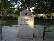 In 1987, a monument
and eternal flame
were contstructed for residents who have died in war:
roadside attraction
, which has been featured on national television.
of 2000, there were 1,198 people, 463 households, and 321 families residing in the town. The population density
was 1,034.5 people per square mile (398.8/km2). There were 532 housing units at an average density of 459.4 per square mile (177.1/km2). The racial makeup of the town was 29.47% White, 68.86% African American, 0.33% Native American, 0.17% Asian, 0.33% from other races
, and 0.83% from two or more races. Hispanic or Latino of any race were 0.67% of the population.
There were 463 households out of which 33.0% had children under the age of 18 living with them, 39.1% were married couples
living together, 24.4% had a female householder with no husband present, and 30.5% were non-families. 28.5% of all households were made up of individuals and 14.3% had someone living alone who was 65 years of age or older. The average household size was 2.58 and the average family size was 3.16.
In the town the population was spread out with 27.4% under the age of 18, 9.6% from 18 to 24, 26.9% from 25 to 44, 21.8% from 45 to 64, and 14.4% who were 65 years of age or older. The median age was 37 years. For every 100 females there were 88.4 males. For every 100 females age 18 and over, there were 79.4 males.
The median income for a household in the town was $22,750, and the median income for a family was $29,167. Males had a median income of $25,583 versus $18,828 for females. The per capita income
for the town was $11,662. About 23.0% of families and 30.3% of the population were below the poverty line, including 39.4% of those under age 18 and 25.0% of those age 65 or over.
South Carolina
South Carolina is a state in the Deep South of the United States that borders Georgia to the south, North Carolina to the north, and the Atlantic Ocean to the east. Originally part of the Province of Carolina, the Province of South Carolina was one of the 13 colonies that declared independence...
, United States
United States
The United States of America is a federal constitutional republic comprising fifty states and a federal district...
. The population was 1,198 at the 2000 census.
Geography
Bowman is located at 33.347658°N 80.683915°W.According to the United States Census Bureau
United States Census Bureau
The United States Census Bureau is the government agency that is responsible for the United States Census. It also gathers other national demographic and economic data...
, the town has a total area of 1.2 square miles (3.1 km²), all of it land.
History
Interest in building a town at the intersection of present day US 178U.S. Route 178
U.S. Highway 178 is a spur of U.S. Highway 78. It currently runs for 237 miles from Dorchester, South Carolina at U.S. Highway 78 to Rosman, North Carolina at U.S. Highway 64. It passes through the states of South Carolina and North Carolina...
(Charleston
Charleston, South Carolina
Charleston is the second largest city in the U.S. state of South Carolina. It was made the county seat of Charleston County in 1901 when Charleston County was founded. The city's original name was Charles Towne in 1670, and it moved to its present location from a location on the west bank of the...
Highway) and S.C. 210 (Branchville-Providence Roads) was evidenced in the acquisition of substantial properties of the Reddick A. Bowman estate by one Samuel W. Dibble, Sr. of Orangeburg, SC in 1887. The Smoak Tramway, a six-mile logging railroad extending from Branchville toward north Four Holes Swamp which was chartered in 1884, was also targeted for acquisition by Mr. Dibble's associate, Thomas M. Raysor, who operated the Raysor Mill near Stokes. These actions, aimed at developing and exploiting the agricultural and lumbering potential of an area that had remained rather dormant since the American Civil War
American Civil War
The American Civil War was a civil war fought in the United States of America. In response to the election of Abraham Lincoln as President of the United States, 11 southern slave states declared their secession from the United States and formed the Confederate States of America ; the other 25...
, were taking place in the late 1880s. These represented the prelude to the chartering of the future Town of Bowman and the transportation and land development organizations and operations which preceded its chartering. The site chosen for Bowman was actually situated in the center of a rice farming country, later transformed into a major cotton producing area where the land has a clay sub-soil, ideal for this and other crops. it was located on an old road that was traveled in colonial days by people going from Charleston to Orangeburg, and which was once alleged to have been known as Oak Ridge, a plateau about ten miles long and five miles wide.
Tornado
On the afternoon of December 5, 1977 a tornado, approaching from the west parallel to Highway 210, struck the downtown area. Three people were injured, the streets were littered with glass and debris, a few trailers demolished, buildings unroofed, and a power failure occurred. Miraculously, no lives were lost.Post Office
In the early years immediately prior to the founding of Bowman, mail service amounted to once or twice-a-week deliveries from Orangeburg by horse and buggy to outlying communities, such as Rileys, Connors and Ruples. The first post officePost office
A post office is a facility forming part of a postal system for the posting, receipt, sorting, handling, transmission or delivery of mail.Post offices offer mail-related services such as post office boxes, postage and packaging supplies...
in the Town of Bowman was located at Railroad Avenue and Ott Street (later Main Street) in the store of John W. Berry, a pioneer merchant, and he served as the first postmaster. The building also served as a residence, and it had the first telephone between Bowman and Branchville. The postal system of those early years in Bowman's history involved horse and buggy deliveries about twice a week from Orangeburg, and patrons from both town and surrounding areas had to pick up their mail from the post office until rural routes and carriers were organized to deliver mail outside the town limits in the early 1900s. Three rural routes were operational by 1907. The earliest carriers of record were W. H. Dukes, W. L. Bishop, O. P. Evans and Andrew Stroman, Sr. A fourth route was later added to serve the surrounding area, since reduced to three, and finally to the current two routes.
War Memorial
Monument
A monument is a type of structure either explicitly created to commemorate a person or important event or which has become important to a social group as a part of their remembrance of historic times or cultural heritage, or simply as an example of historic architecture...
and eternal flame
Eternal flame
An eternal flame is a flame or torch that burns day and night for an indefinite period. The flame that burned constantly at Delphi was an archaic feature, "alien to the ordinary Greek temple"....
were contstructed for residents who have died in war:
- World War IWorld War IWorld War I , which was predominantly called the World War or the Great War from its occurrence until 1939, and the First World War or World War I thereafter, was a major war centred in Europe that began on 28 July 1914 and lasted until 11 November 1918...
- James Edward Easterlin
- John Wesley Weathers
- John Moorer Livingston
- World War IIWorld War IIWorld War II, or the Second World War , was a global conflict lasting from 1939 to 1945, involving most of the world's nations—including all of the great powers—eventually forming two opposing military alliances: the Allies and the Axis...
- James Edmund Berry
- Thomas Richard Edwards
- Leonard Everett Berry
- George Arthur Kemmerlin
- Benjamin Franklin Knight
- Vietnam WarVietnam WarThe Vietnam War was a Cold War-era military conflict that occurred in Vietnam, Laos, and Cambodia from 1 November 1955 to the fall of Saigon on 30 April 1975. This war followed the First Indochina War and was fought between North Vietnam, supported by its communist allies, and the government of...
- James Allen Johnson
- Henry Dennis West, III
- Jessie Clarence Felder
UFO Welcome Center
Bowman is home to the UFO Welcome CenterUFO Welcome Center
The UFO Welcome Center is a tourist curiosity located in Bowman, South Carolina, built in the back yard of Jody Pendarvis. It consists of a built out of wood, fiberglass, and plastic. The structure, entered by a powered ramp, is mounted on four columns, designed to raise and lower with motors...
roadside attraction
Roadside attraction
A roadside attraction is a feature along the side of a road, that is frequently advertised with billboards to attract tourists. In general, these are places one might stop on the way to somewhere else, rather than being a final or primary destination in and of themselves. The modern...
, which has been featured on national television.
Demographics
As of the censusCensus
A census is the procedure of systematically acquiring and recording information about the members of a given population. It is a regularly occurring and official count of a particular population. The term is used mostly in connection with national population and housing censuses; other common...
of 2000, there were 1,198 people, 463 households, and 321 families residing in the town. The population density
Population density
Population density is a measurement of population per unit area or unit volume. It is frequently applied to living organisms, and particularly to humans...
was 1,034.5 people per square mile (398.8/km2). There were 532 housing units at an average density of 459.4 per square mile (177.1/km2). The racial makeup of the town was 29.47% White, 68.86% African American, 0.33% Native American, 0.17% Asian, 0.33% from other races
Race (United States Census)
Race and ethnicity in the United States Census, as defined by the Federal Office of Management and Budget and the United States Census Bureau, are self-identification data items in which residents choose the race or races with which they most closely identify, and indicate whether or not they are...
, and 0.83% from two or more races. Hispanic or Latino of any race were 0.67% of the population.
There were 463 households out of which 33.0% had children under the age of 18 living with them, 39.1% were married couples
Marriage
Marriage is a social union or legal contract between people that creates kinship. It is an institution in which interpersonal relationships, usually intimate and sexual, are acknowledged in a variety of ways, depending on the culture or subculture in which it is found...
living together, 24.4% had a female householder with no husband present, and 30.5% were non-families. 28.5% of all households were made up of individuals and 14.3% had someone living alone who was 65 years of age or older. The average household size was 2.58 and the average family size was 3.16.
In the town the population was spread out with 27.4% under the age of 18, 9.6% from 18 to 24, 26.9% from 25 to 44, 21.8% from 45 to 64, and 14.4% who were 65 years of age or older. The median age was 37 years. For every 100 females there were 88.4 males. For every 100 females age 18 and over, there were 79.4 males.
The median income for a household in the town was $22,750, and the median income for a family was $29,167. Males had a median income of $25,583 versus $18,828 for females. The per capita income
Per capita income
Per capita income or income per person is a measure of mean income within an economic aggregate, such as a country or city. It is calculated by taking a measure of all sources of income in the aggregate and dividing it by the total population...
for the town was $11,662. About 23.0% of families and 30.3% of the population were below the poverty line, including 39.4% of those under age 18 and 25.0% of those age 65 or over.