
Bowles West Peak
Encyclopedia

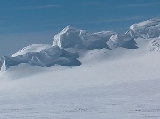
Bowles Ridge
Bowles Ridge is the central ridge of eastern Livingston Island. The ridge extends 6.5 km in the east-west direction and is 1.5 km wide. The summit of the ridge is Mount Bowles which rises to 822m and is located 9.77 km northwest of Great Needle Peak, 6.08 km north by west of...
in eastern Livingston Island in Antarctica. The peak has steep and partly ice free western slopes and overlooks Perunika Glacier to the southwest.
The feature takes its name from Mount Bowles.
Location
The peak is located at 62°36′47.5"S 60°13′13"W which is 1 km west by north of Mount BowlesMount Bowles
Mount Bowles is an ice-covered mountain of elevation 822 m, the summit of Bowles Ridge in eastern Livingston Island, South Shetland Islands. Situated 3 mi north of Mount Friesland to which it is linked by Wörner Gap. Coordinates and elevation given according to 2003 Australian GPS survey...
(822 m), 790 m south by east of Hemus Peak
Hemus Peak
Hemus Peak is an ice-covered peak rising to 636 m off the northwest extremity of Bowles Ridge in eastern Livingston Island. The feature is breast-shaped, 850 m long in east-west direction and 550 m wide, and overlooks Kaliakra Glacier to the northeast and Perunika Glacier to the southwest...
, 6.24 km east of Aleko Rock and 3.2 km east by northeast of Rezen Knoll
Rezen Knoll
Rezen Knoll is a knoll rising to 433 m in eastern Livingston Island in the South Shetland Islands, Antarctica. The knoll is bounded to the east, north and west by Perunika Glacier, and linked to Burdick Ridge by Rezen Saddle. The feature is 250 m wide, extending 500 m in east-west direction....
.
The peak was roughly mapped by the British in 1968 and the Spanish in 1991. The peak was mapped by Bulgaria from a 1995-96 topographic survey.
Maps
- L.L. Ivanov et al. Antarctica: Livingston Island and Greenwich Island, South Shetland Islands. Scale 1:100000 topographic map. Sofia: Antarctic Place-names Commission of Bulgaria, 2005.
- L.L. Ivanov. Antarctica: Livingston Island and Greenwich, Robert, Snow and Smith Islands. Scale 1:120000 topographic map. Troyan: Manfred Wörner Foundation, 2009.