
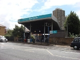
Bow Church DLR station
Encyclopedia
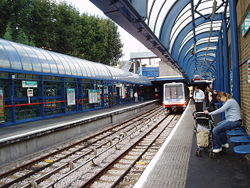
Bow Church station is a station on the Docklands Light Railway
(DLR) on Bow Road
, in the Bow
neighbourhood of east London
. The station is located on the DLR's Stratford branch
, between Devons Road
and Pudding Mill Lane
stations and is in Travelcard Zone 2
. It is within 300 m walking distance of Bow Road station
on London Underground
's District
and Hammersmith and City
lines. Through ticketing is allowed between both stations. The DLR station opened with the original system on 31 August 1987.
There is a crossover south of the station which allows trains from Stratford and Poplar to reverse here.
One example of this is when the new platforms at Stratford were being constructed - trains were suspended between Bow Church and Stratford and trains from Poplar terminated here.
Docklands Light Railway
The Docklands Light Railway is an automated light metro or light rail system opened on 31 August 1987 to serve the redeveloped Docklands area of London...
(DLR) on Bow Road
Bow Road
Bow Road is a thoroughfare in Bow, Tower Hamlets, London, England. The road forms part of the A11, running from Aldgate to Norwich in Norfolk. To the west the road becomes Mile End Road, and to the east at the Bow Interchange roundabout, there is a junction with the A12.The College of Technology...
, in the Bow
Bow, London
Bow is an area of London, England, United Kingdom in the London Borough of Tower Hamlets. It is a built-up, mostly residential district located east of Charing Cross, and is a part of the East End.-Bridges at Bowe:...
neighbourhood of east London
London
London is the capital city of :England and the :United Kingdom, the largest metropolitan area in the United Kingdom, and the largest urban zone in the European Union by most measures. Located on the River Thames, London has been a major settlement for two millennia, its history going back to its...
. The station is located on the DLR's Stratford branch
Stratford station
Stratford station is a large multilevel railway station in Stratford, east London. The station is served by the National Rail services National Express East Anglia, London Overground and c2c, by London Underground's Central and Jubilee lines, and by the Docklands Light Railway . Stratford is in...
, between Devons Road
Devons Road DLR station
Devons Road station is a station on the Docklands Light Railway in east London, serving Bromley-by-Bow to the north and Poplar to the south and west...
and Pudding Mill Lane
Pudding Mill Lane DLR station
Pudding Mill Lane DLR station is a station on the Docklands Light Railway in east London. It is situated in the road of the same name in a light industrial area...
stations and is in Travelcard Zone 2
Travelcard Zone 2
Fare zone 2 is an inner zone of Transport for London's zonal fare system used for calculating the price of tickets for travel on the London Underground, London Overground, Docklands Light Railway and, since 2007, on National Rail services.-Background:...
. It is within 300 m walking distance of Bow Road station
Bow Road tube station
Bow Road tube station is on the District and Hammersmith & City lines of the London Underground. It is on Bow Road in Bow, east London, about 300 metres from Bow Church DLR station and is in fare zone 2...
on London Underground
London Underground
The London Underground is a rapid transit system serving a large part of Greater London and some parts of Buckinghamshire, Hertfordshire and Essex in England...
's District
District Line
The District line is a line of the London Underground, coloured green on the Tube map. It is a "sub-surface" line, running through the central area in shallow cut-and-cover tunnels. It is the busiest of the sub-surface lines. Out of the 60 stations served, 25 are underground...
and Hammersmith and City
Hammersmith & City Line
The Hammersmith & City line is a subsurface London Underground line. It connects Hammersmith in the west with Barking in the east, running through the northern part of central London. It is coloured salmon pink on the Tube map...
lines. Through ticketing is allowed between both stations. The DLR station opened with the original system on 31 August 1987.
There is a crossover south of the station which allows trains from Stratford and Poplar to reverse here.
One example of this is when the new platforms at Stratford were being constructed - trains were suspended between Bow Church and Stratford and trains from Poplar terminated here.