
Bluff Knoll
Encyclopedia
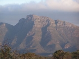
Bluff Knoll is a peak in the Stirling Range
in the south-west
of Western Australia
(WA). It is 1099 metres (3,605.6 ft) above sea level, and is one of only a few places to experience regular snowfalls in Western Australia, with some snow reported in most years. The last heavy snowfall was on 6 October 1992 when 20 centimetres of snow was recorded and light snow was seen at the base, 450 metres (1,476.4 ft). Although Bluff Knoll is sometimes claimed to be the highest point in WA, the highest peak is actually Mount Meharry
in Karijini National Park
in the Hamersley Range
, which is 1249 metres (4,097.8 ft) above sea level.
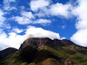
Local Aboriginal people, from the Qaaniyan and Koreng
groups (or tribes), who wore kangaroo skin cloaks in cold weather, called the mountain Pualaar Miial, meaning "great many-faced hill". The mountain is often shrouded in a mist which curls around the peaks and floats into the gullies. Local people believed this to be a spirit named Noatch (literally meaning "dead body" or "corpse").
Climbing Bluff Knoll, a round trip of about 6 kilometres (3.7 mi), takes three to four hours, and can be achieved by anyone with a reasonable level of fitness. It is important to be well prepared for the trek, especially in the colder months as many people have been exposed to the cold weather during climbs. Water is essential during summer as dehydration is a common problem for hikers. Many rescues have been performed by local State Emergency Service (SES) units. Hikers who fall and injure themselves may be unable to return to the base unaided. They may also become fatigued or fall victim to the elements. It is possible to ascend the face of the bluff with rock climbing
equipment, or abseil down it, though it is very dangerous and preparation is vital.
The view from the summit encompasses the Stirling and Porongurup
mountain ranges, as well as the coast near Albany
.
Stirling Range
The Stirling Range or Koikyennuruff is a range of mountains and hills in the Great Southern region of Western Australia, 337 km south-east of Perth. It is located at approximately and is over 60 km wide from west to east, stretching from the highway between Mount Barker and Cranbrook...
in the south-west
Southwest, Western Australia
The Southwest is a loosely defined area in the southwest corner of Western Australia. Various regionalisations have provided formal definitions of the area, but these do not coincide.* For the drainage division, see Southwest corner of Western Australia...
of Western Australia
Western Australia
Western Australia is a state of Australia, occupying the entire western third of the Australian continent. It is bounded by the Indian Ocean to the north and west, the Great Australian Bight and Indian Ocean to the south, the Northern Territory to the north-east and South Australia to the south-east...
(WA). It is 1099 metres (3,605.6 ft) above sea level, and is one of only a few places to experience regular snowfalls in Western Australia, with some snow reported in most years. The last heavy snowfall was on 6 October 1992 when 20 centimetres of snow was recorded and light snow was seen at the base, 450 metres (1,476.4 ft). Although Bluff Knoll is sometimes claimed to be the highest point in WA, the highest peak is actually Mount Meharry
Mount Meharry
Mount Meharry is the highest mountain in Western Australia. It is located in the Hamersley Range within the southeastern part of Karijini National Park in the Pilbara region, approximately from Wittenoom, and from Tom Price....
in Karijini National Park
Karijini National Park
Karijini National Park is a National Park centred in the Hamersley Ranges of the Pilbara region in northwestern Western Australia . It is just north of the Tropic of Capricorn, approximately 1055 km from the State's capital city, Perth...
in the Hamersley Range
Hamersley Range
The Hamersley Ranges is a mountainous region of the Pilbara, Western Australia. The range runs from the Fortescue River in the northeast, 460 km south. The range contains Western Australia's highest point, Mount Meharry, which reaches approximately AHD. There are many extensively-eroded...
, which is 1249 metres (4,097.8 ft) above sea level.
Local Aboriginal people, from the Qaaniyan and Koreng
Koreng
The Koreng are an Australian Aboriginal group originating from the south-west of Western Australia, around the Stirling Ranges....
groups (or tribes), who wore kangaroo skin cloaks in cold weather, called the mountain Pualaar Miial, meaning "great many-faced hill". The mountain is often shrouded in a mist which curls around the peaks and floats into the gullies. Local people believed this to be a spirit named Noatch (literally meaning "dead body" or "corpse").
Climbing Bluff Knoll, a round trip of about 6 kilometres (3.7 mi), takes three to four hours, and can be achieved by anyone with a reasonable level of fitness. It is important to be well prepared for the trek, especially in the colder months as many people have been exposed to the cold weather during climbs. Water is essential during summer as dehydration is a common problem for hikers. Many rescues have been performed by local State Emergency Service (SES) units. Hikers who fall and injure themselves may be unable to return to the base unaided. They may also become fatigued or fall victim to the elements. It is possible to ascend the face of the bluff with rock climbing
Rock climbing
Rock climbing also lightly called 'The Gravity Game', is a sport in which participants climb up, down or across natural rock formations or artificial rock walls. The goal is to reach the summit of a formation or the endpoint of a pre-defined route without falling...
equipment, or abseil down it, though it is very dangerous and preparation is vital.
The view from the summit encompasses the Stirling and Porongurup
Porongurup National Park
Porongurup National Park is a national park in the Great Southern region of Western Australia , 360 km southeast of Perth and 40 km from Albany....
mountain ranges, as well as the coast near Albany
Albany, Western Australia
Albany is a port city in the Great Southern region of Western Australia, some 418 km SE of Perth, the state capital. As of 2009, Albany's population was estimated at 33,600, making it the 6th-largest city in the state....
.