

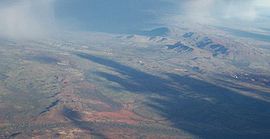
Hamersley Range
Encyclopedia

Pilbara region of Western Australia
The Pilbara is a large, dry, thinly populated region in the north of Western Australia known for its vast mineral deposits, in particular iron ore...
, Western Australia
Western Australia
Western Australia is a state of Australia, occupying the entire western third of the Australian continent. It is bounded by the Indian Ocean to the north and west, the Great Australian Bight and Indian Ocean to the south, the Northern Territory to the north-east and South Australia to the south-east...
. The range runs from the Fortescue River
Fortescue River
The Fortescue River is an ephemeral river in the Pilbara region of Western Australia. It is the third longest river in the state.The river rises near Deadman Hill in the Ophthalmia Range about 30 km South of Newman. The river flows in a Northerly direction parallel with the Great Northern...
in the northeast, 460 km south. The range contains Western Australia's highest point, Mount Meharry
Mount Meharry
Mount Meharry is the highest mountain in Western Australia. It is located in the Hamersley Range within the southeastern part of Karijini National Park in the Pilbara region, approximately from Wittenoom, and from Tom Price....
, which reaches approximately 1249 metres (4,098 ft) AHD
Australian Height Datum
The Australian Height Datum is a geodetic datum for altitude measurement in Australia. According to Geoscience Australia, "In 1971 the mean sea level for 1966-1968 was assigned the value of zero on the Australian Height Datum at thirty tide gauges around the coast of the Australian continent...
. There are many extensively-eroded gorges, such as Wittenoom Gorge. The twenty highest peaks in Western Australia are in the Hamersley Range.
Geologically, they are some of the most ancient regions of the earth's crust known as the Pilbara craton
Pilbara craton
The Pilbara craton , along with the Kaapvaal craton are the only remaining areas of pristine Archaean 3.6-2.7 Ga crust on Earth...
.
Some of the Peaks found in the range include Mount Bruce
Mount Bruce (Western Australia)
Mount Bruce is the second highest mountain in the state of Western Australia.Mount Bruce lies northwest of Mount Meharry, the highest peak in the state. It is a part of the Hamersley Range in the Pilbara...
(1234 metres (4,049 ft)), Mount Nameless (1115 metres (3,658 ft)), Mount Reeder Nichols (1109 metres (3,638 ft)), Mount Samson (1107 metres (3,632 ft)), Mount Truchanas (1148 metres (3,766 ft)) and Mount Tom Price (775 metres (2,543 ft)).
Karijini National Park
Karijini National Park
Karijini National Park is a National Park centred in the Hamersley Ranges of the Pilbara region in northwestern Western Australia . It is just north of the Tropic of Capricorn, approximately 1055 km from the State's capital city, Perth...
(formerly Hamersley National Park), one of Australia's largest National Park
National park
A national park is a reserve of natural, semi-natural, or developed land that a sovereign state declares or owns. Although individual nations designate their own national parks differently A national park is a reserve of natural, semi-natural, or developed land that a sovereign state declares or...
s, is centred in the range.
Banded iron formation
Banded iron formations are distinctive units of sedimentary rock that are almost always of Precambrian age. A typical BIF consists of repeated, thin layers of iron oxides, either magnetite or hematite , alternating with bands of iron-poor shale and chert...
(BIF) - also known as the Brockman iron formation
Western Australia's major iron producers have mines, communities and railways that occur along the range Rio Tinto
Rio Tinto Group
The Rio Tinto Group is a diversified, British-Australian, multinational mining and resources group with headquarters in London and Melbourne. The company was founded in 1873, when a multinational consortium of investors purchased a mine complex on the Rio Tinto river, in Huelva, Spain from the...
operates several iron ore mines within the range including Marandoo
Marandoo mine
The Marandoo mine is an iron ore mine located in the Pilbara region of Western Australia, 45 kilometres east of Tom Price.The mine is fully owned and operated by Rio Tinto Iron Ore and is one of twelve iron ore mines the company operates in the Pilbara. In the calendar year 2009, the combined...
, Brockman
Brockman mine
The Brockman mine is an iron ore mine located in the Pilbara region of Western Australia, 60 kilometres north-west of Tom Price. It is sometimes also referred to as Brockman 2 mine to differentiate between it and Rio Tinto's new Brockman 4 mine project, also in the area.The mine is fully owned and...
, Channar
Channar mine
The Channar mine is an iron ore mine located in the Pilbara region of Western Australia, 17 kilometres south-east of Paraburdoo.The mine is partly owned and operated by Rio Tinto Iron Ore and is one of twelve iron ore mines the company operates in the Pilbara...
, West Angelas
West Angelas mine
The West Angelas mine is an iron ore mine located in the Pilbara region of Western Australia, 110 kilometres west of Newman.The mine is owned by Robe River Iron Associates and operated by Rio Tinto Iron Ore and is one of twelve iron ore mines the company operates in the Pilbara...
and Paraburdoo
Paraburdoo mine
The Paraburdoo mine is an iron ore mine located in the Pilbara region of Western Australia, near Paraburdoo.The mine is fully owned and operated by Rio Tinto Iron Ore and is one of twelve iron ore mines the company operates in the Pilbara. In the calendar year 2009, the combined Pilbara operations...
. Over 100 million tonnes of iron ore is removed from the range every year.
Further reading
- Marshall, Lloyd (1966) New Iron Age in the Hamersleys in the Weekend News, Sept. 3, 1966.
- Powell, C. McA et al. (1994) Late Archaean and early Proterozoic tectonics and basin formation of the Hamersley Ranges East Perth, W.A. Geological Society of Australia (W.A. Division) "12th Australian Geological Convention, September 1994". Excursion guidebook, 0819-6613 ; no. 4. ISBN 0-909869-90-1.