
.gif)
County Route 97 (Rockland County, New York)
Encyclopedia
County Route 97 is a 0.97 miles (1.56 km) long county highway in the western part of Rockland County, New York
. CR 97 begins at the Sloatsburg village line, and ends at a dead end in Harriman State Park. CR 97 does not enter the village limits of any town in Rockland County, therefore it is designated in the Town of Ramapo. After CR 97's southern terminus, the road continues as Johnstown Rd, which continues for another half-mile before ending at Seven Lakes Drive
.
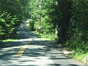
CR 97 is the most hidden Rockland County Route as there are no indictations that it exists. Johnstown Rd is a small, narrow road that appears to be nothing more than a dead end. However, it quickly changes to a two-lane road, and CR 97 begins. CR 97 runs the southern border of Dater Mountain Nature County Park for most of its route. At the northern terminus of CR 97, there are two hiking trails that lead into Harriman State Park. CR 97 does not intersect any major routes along its run.
 Johnsontown Road begins just after the overpass for the New York State Thruway
on Seven Lakes Drive
. The road makes a large curve to the north and begins to parallel Seven Lakes Drive. After a while, a connector road back to Seven Lakes Drive leaves to the right. The road is renamed Stony Brook Drive after this. County Route 97 begins shortly after this point heading parallel to Seven Lakes Drive. No roads intersect CR 97 from this point, as the road goes for a mile, dead ending at a cul-de-sac in Ramapo
.
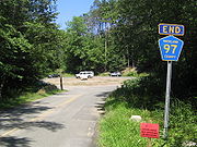
At the northern terminus of CR 97, there are two hiking trails that lead into Harriman State Park. There is the Blue Disc Trail, just before the cul-de-sac and the White Bar Trail, which begins at the northern end of the cul-de-sac.
 Stony Brook Drive, now Johnsontown Road, begins at Seven Lakes Drive, just after the Thruway underpass. It was once a main park drive that went all the way to Lake Sebago and Little Long Pond. From the 1920s to 1962, maps recognized this street as Stony Brook Drive. The name, after 1962, was changed to Johnsontown Road, named after the old village. The road is now just a 1.6 miles (2.6 km) road that ends at a cul-de-sac.
Rockland County, New York
Rockland County is a suburban county 15 miles to the northwest of Manhattan and part of the New York City Metropolitan Area, in the U.S. state of New York. It is the southernmost county in New York west of the Hudson River, and the smallest county in New York outside of New York City. The...
. CR 97 begins at the Sloatsburg village line, and ends at a dead end in Harriman State Park. CR 97 does not enter the village limits of any town in Rockland County, therefore it is designated in the Town of Ramapo. After CR 97's southern terminus, the road continues as Johnstown Rd, which continues for another half-mile before ending at Seven Lakes Drive
Seven Lakes Drive
Seven Lakes Drive is a 17.91 mile long parkway in the U.S. state of New York. The southern terminus of the route is at New York State Route 17 in Sloatsburg. The northern terminus is at U.S. Route 9W and U.S. Route 202 a mile south of Fort Montgomery in Bear Mountain State Park...
.
CR 97 is the most hidden Rockland County Route as there are no indictations that it exists. Johnstown Rd is a small, narrow road that appears to be nothing more than a dead end. However, it quickly changes to a two-lane road, and CR 97 begins. CR 97 runs the southern border of Dater Mountain Nature County Park for most of its route. At the northern terminus of CR 97, there are two hiking trails that lead into Harriman State Park. CR 97 does not intersect any major routes along its run.
Route description
New York State Thruway
The New York State Thruway is a system of limited-access highways located within the state of New York in the United States. The system, known officially as the Governor Thomas E. Dewey Thruway for former New York Governor Thomas E. Dewey, is operated by the New York State Thruway Authority and...
on Seven Lakes Drive
Seven Lakes Drive
Seven Lakes Drive is a 17.91 mile long parkway in the U.S. state of New York. The southern terminus of the route is at New York State Route 17 in Sloatsburg. The northern terminus is at U.S. Route 9W and U.S. Route 202 a mile south of Fort Montgomery in Bear Mountain State Park...
. The road makes a large curve to the north and begins to parallel Seven Lakes Drive. After a while, a connector road back to Seven Lakes Drive leaves to the right. The road is renamed Stony Brook Drive after this. County Route 97 begins shortly after this point heading parallel to Seven Lakes Drive. No roads intersect CR 97 from this point, as the road goes for a mile, dead ending at a cul-de-sac in Ramapo
Ramapo, New York
Ramapo , formerly known as New Hempstead and then Hampstead, is a town in Rockland County, New York, United States located north of New Jersey; southeast of Orange County, New York; south of the Town of Haverstraw and west of the Town of Clarkstown and the Town of Orangetown...
.
At the northern terminus of CR 97, there are two hiking trails that lead into Harriman State Park. There is the Blue Disc Trail, just before the cul-de-sac and the White Bar Trail, which begins at the northern end of the cul-de-sac.
History