
Bitterne Park
Overview
Wards of the United Kingdom
A ward in the United Kingdom is an electoral district at sub-national level represented by one or more councillors. It is the primary unit of British administrative and electoral geography .-England:...
of Southampton
Southampton
Southampton is the largest city in the county of Hampshire on the south coast of England, and is situated south-west of London and north-west of Portsmouth. Southampton is a major port and the closest city to the New Forest...
, England
England
England is a country that is part of the United Kingdom. It shares land borders with Scotland to the north and Wales to the west; the Irish Sea is to the north west, the Celtic Sea to the south west, with the North Sea to the east and the English Channel to the south separating it from continental...
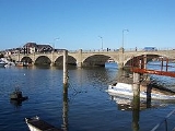
, on the Eastern bank of the River Itchen
River Itchen, Hampshire
The River Itchen is a river in Hampshire, England. It flows from mid-Hampshire to join with Southampton Water below the Itchen Bridge in the city of Southampton. The river has a total length of , and is noted as one of England's - if not one of the World's - premier chalk streams for fly fishing,...
, built on sloping parkland which once formed part of Bitterne Manor
Bitterne Manor
Bitterne Manor is a suburb of Southampton surrounding the manor house of the same name.- History :Bitterne Manor is the site of the original Roman settlement of Clausentum, the forerunner to today's City of Southampton....
.
Bitterne Park Ward includes the suburbs of Bitterne Park, Bitterne Manor
Bitterne Manor
Bitterne Manor is a suburb of Southampton surrounding the manor house of the same name.- History :Bitterne Manor is the site of the original Roman settlement of Clausentum, the forerunner to today's City of Southampton....
, Midanbury
Midanbury
Midanbury is a small suburb of Southampton, England, bordering Bitterne, Bitterne Park and Townhill Park.-History:It is named after the country house "Midanbury Lodge" which was situated on the summit of a hill to the east of Southampton. The house no longer stands, and the land was used for...
and Townhill Park
Townhill Park
Townhill Park is a suburb of Southampton, England, bordering Swaythling, Bitterne Park and West End. It is built on land which once belonged to the house which carries the same name.- History :...
, and had a population of 13,276 as of the 2001 Census
United Kingdom Census 2001
A nationwide census, known as Census 2001, was conducted in the United Kingdom on Sunday, 29 April 2001. This was the 20th UK Census and recorded a resident population of 58,789,194....
. The ward is bounded by Bevois
Bevois
Bevois is an Electoral Ward in the Unitary Authority of Southampton, England comprising the suburbs Bevois Valley, Nicholstown and Northam, with a population of 13,621....
, Portswood
Portswood
Portswood is a suburb and Electoral Ward of Southampton, England. The suburb lies to the north-east of the city centre and is bounded by Freemantle, Highfield, Swaythling, St. Denys and Bevois Valley....
and Swaythling
Swaythling
Swaythling was once a village but over the years it has gradually become a suburb and electoral ward of Southampton in Hampshire, England. The ward has a population of 13,394....
wards across the River Itchen
River Itchen, Hampshire
The River Itchen is a river in Hampshire, England. It flows from mid-Hampshire to join with Southampton Water below the Itchen Bridge in the city of Southampton. The river has a total length of , and is noted as one of England's - if not one of the World's - premier chalk streams for fly fishing,...
to the west, and Harefield
Harefield, Hampshire
Harefield is a suburb and Electoral Ward near Bitterne in Southampton, England. The entire suburb consists of a council housing estate built around 1960 on the estate of Harefield House....
and Peartree
Peartree (ward)
Peartree Ward is an Electoral Ward in the Unitary Authority of Southampton, England.It covers the suburbs of Merry Oak, Peartree Green and Itchen, and is bordered by Bargate Ward, Bevois Ward, Bitterne Park Ward, Harefield Ward, Sholing Ward, and Woolston Ward....
wards to the east.
The National Liberal Land Company purchased the land that is now Bitterne Park in 1882, and began developing it for residential purposes.