

Bismarck-Mandan
Encyclopedia
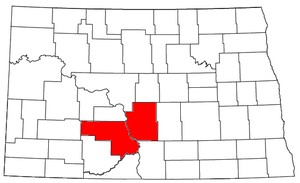
Metropolitan area
The term metropolitan area refers to a region consisting of a densely populated urban core and its less-populated surrounding territories, sharing industry, infrastructure, and housing. A metropolitan area usually encompasses multiple jurisdictions and municipalities: neighborhoods, townships,...
(known as the "Bismarck
Bismarck, North Dakota
Bismarck is the capital of the U.S. state of North Dakota and the county seat of Burleigh County. It is the second most populous city in North Dakota after Fargo. The city's population was 61,272 at the 2010 census, while its metropolitan population was 108,779...
, ND
North Dakota
North Dakota is a state located in the Midwestern region of the United States of America, along the Canadian border. The state is bordered by Canada to the north, Minnesota to the east, South Dakota to the south and Montana to the west. North Dakota is the 19th-largest state by area in the U.S....
Metropolitan Statistical Area") composed of Burleigh
Burleigh County, North Dakota
-National protected areas:*Canfield Lake National Wildlife Refuge*Florence Lake National Wildlife Refuge*Long Lake National Wildlife Refuge -Demographics:...
and Morton
Morton County, North Dakota
-Demographics:As of the census of 2000, there were 25,303 people, 9,889 households, and 6,932 families residing in the county. The population density was 13 people per square mile . There were 10,587 housing units at an average density of 6 per square mile...
counties in the U.S. state
U.S. state
A U.S. state is any one of the 50 federated states of the United States of America that share sovereignty with the federal government. Because of this shared sovereignty, an American is a citizen both of the federal entity and of his or her state of domicile. Four states use the official title of...
of North Dakota
North Dakota
North Dakota is a state located in the Midwestern region of the United States of America, along the Canadian border. The state is bordered by Canada to the north, Minnesota to the east, South Dakota to the south and Montana to the west. North Dakota is the 19th-largest state by area in the U.S....
. It's sometimes called the Bis-Man Metro Area or The Sisters Cities of North Dakota. Its core city is Bismarck
Bismarck, North Dakota
Bismarck is the capital of the U.S. state of North Dakota and the county seat of Burleigh County. It is the second most populous city in North Dakota after Fargo. The city's population was 61,272 at the 2010 census, while its metropolitan population was 108,779...
, the capital of North Dakota; Mandan
Mandan, North Dakota
As of the census of 2000, there were 16,718 people, 6,647 households, and 4,553 families residing in the city. The population density was 1,642.8 per square mile . There were 6,958 housing units at an average density of 683.7 per square mile...
, which lies across the Missouri River
Missouri River
The Missouri River flows through the central United States, and is a tributary of the Mississippi River. It is the longest river in North America and drains the third largest area, though only the thirteenth largest by discharge. The Missouri's watershed encompasses most of the American Great...
from Bismarck, is the second largest city in the metropolitan area. The population was 94,719 at the 2000 census
United States Census, 2000
The Twenty-second United States Census, known as Census 2000 and conducted by the Census Bureau, determined the resident population of the United States on April 1, 2000, to be 281,421,906, an increase of 13.2% over the 248,709,873 persons enumerated during the 1990 Census...
. A 2009 estimate placed the population at 106,286.
Other cities
- AlmontAlmont, North DakotaAs of the census of 2000, there were 89 people, 43 households, and 22 families residing in the city. The population density was 33.8 people per square mile . There were 63 housing units at an average density of 23.9 per square mile...
- FlasherFlasher, North DakotaAs of the census of 2000, there were 285 people, 130 households, and 72 families residing in the city. The population density was 408.0 people per square mile . There were 155 housing units at an average density of 221.9 per square mile . The racial makeup of the city was 97.89% White, 0.35% Native...
- Glen UllinGlen Ullin, North DakotaAs of the census of 2000, there were 865 people, 369 households, and 221 families residing in the city. The population density was 831.2 people per square mile . There were 405 housing units at an average density of 389.2 per square mile...
- HebronHebron, North DakotaAs of the census of 2000, there were 803 people, 357 households, and 228 families residing in the city. The population density was 539.2 people per square mile . There were 434 housing units at an average density of 291.4 per square mile...
- LincolnLincoln, North DakotaAs of the census of 2000, there were 1,730 people, 527 households, and 452 families residing in the city. The population density was 1,700.3 people per square mile . There were 541 housing units at an average density of 531.7 per square mile...
- MandanMandan, North DakotaAs of the census of 2000, there were 16,718 people, 6,647 households, and 4,553 families residing in the city. The population density was 1,642.8 per square mile . There were 6,958 housing units at an average density of 683.7 per square mile...
- McKenzieMcKenzie, North DakotaMcKenzie is an unincorporated community in Burleigh County, North Dakota, United States. It lies about 20 miles east of Bismarck along I-94/US 83. The community was named after early North Dakota politician Alexander McKenzie. McKenzie's ZIP code is 58572....
- MoffitMoffit, North DakotaMoffit is an unincorporated community in Burleigh County, North Dakota, United States. It lies along US 83 10 miles south of Sterling. Moffit's ZIP code is 58560....
- New SalemNew Salem, North DakotaAs of the census of 2000, there were 938 people, 411 households, and 246 families residing in the city. The population density was 649.0 people per square mile . There were 448 housing units at an average density of 310.0 per square mile...
- ReganRegan, North DakotaAs of the census of 2000, there were 43 people, 23 households, and 12 families residing in the city. The population density was 42.6 people per square mile . There were 32 housing units at an average density of 31.7 per square mile...
- SterlingSterling, North DakotaSterling is an unincorporated community in Burleigh County, North Dakota, United States at the intersection of Interstate 94 and U.S. Route 83. It is part of the "Bismarck, ND Metropolitan Statistical Area" or "Bismarck-Mandan". Sterling's US Postal Code is 58572.Sterling was not a...
- WiltonWilton, North DakotaAs of the census of 2000, there were 807 people, 309 households, and 219 families residing in the city. The population density was 1,395.3 people per square mile . There were 347 housing units at an average density of 599.9 per square mile . The racial makeup of the city was 98.27% White, 0.12%...
- WingWing, North DakotaAs of the census of 2000, there were 124 people, 68 households, and 32 families residing in the city. The population density was 210.3 people per square mile . There were 89 housing units at an average density of 150.9 per square mile . The racial makeup of the city was 99.19% White, and 0.81% from...
Demographics
As of the censusCensus
A census is the procedure of systematically acquiring and recording information about the members of a given population. It is a regularly occurring and official count of a particular population. The term is used mostly in connection with national population and housing censuses; other common...
of 2000, there were 94,719 people, 37,559 households, and 25,138 families residing within the MSA. The racial makeup of the MSA was 95.24% White, 0.23% African American, 3.04% Native American, 0.37% Asian, 0.02% Pacific Islander, 0.16% from other races
Race (United States Census)
Race and ethnicity in the United States Census, as defined by the Federal Office of Management and Budget and the United States Census Bureau, are self-identification data items in which residents choose the race or races with which they most closely identify, and indicate whether or not they are...
, and 0.93% from two or more races. Hispanic or Latino of any race were 0.67% of the population.
The median income for a household in the MSA was $39,169, and the median income for a family was $48,339. Males had a median income of $32,726 versus $21,364 for females. The per capita income
Per capita income
Per capita income or income per person is a measure of mean income within an economic aggregate, such as a country or city. It is calculated by taking a measure of all sources of income in the aggregate and dividing it by the total population...
for the MSA was $18,819.