
Benton, California
Encyclopedia
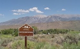
Benton is a census-designated place
in Mono County
, California
, United States
. It is located 3 miles (4.8 km) east-northeast of the community of Benton Hot Springs
and 32 miles (51 km) north of the community of Bishop
, at an elevation of 5387 feet (1642 m). The population was 280 at the 2010 census, up from 196 reported at 2000 by Mono County.
Benton is in area code 760
(and area code 442 overlay) and ZIP code
93512. It is also known as Benton Hot Springs because of the Hot Springs it features. Benton was once a small mining
town with up to 5,000 inhabitants. Many of the original buildings still remain, but the town has never completely died.
The 160 acre (65 hectare) Benton Paiute reservation is in the vicinity with about 50 fulltime residents.
. As the nearby towns of Bodie
and Aurora grew in size and population, Benton soon became a check-point for travelers on the way south in 1852.
Gold
was discovered in the hills of Benton in 1862, and its population quickly grew. After hitting the initial strike of gold, not much more was found, but Benton's profits were soon primarily from silver
. Unlike other mining towns, Benton was able to provide enough for the town to thrive and flourish for about fifty years. Although most of the main activity took place between 1862 and 1890, the town and its inhabitants have never completely died out.
The Carson and Colorado Railroad
reached the place in 1883, and Benton was a stop.
, outside of Bishop
, on the way to remote areas of Nevada
. The terrain is described as high desert
at an elevation of 5377 feet (1,638.9 m) above sea level.
Although Benton is a small town, it is surrounded by other small towns and cities including Mammoth Lakes
, Bishop
, Death Valley, Lee Vining
, June Lake
, Tom's Place
, Crowley Lake
, and Convict Lake.
The Nevada
State Line is situated about 6 miles (10 km) northeast of Benton. U.S. Route 6 crosses this border then climbs over 7,150 foot (2,180 meter) Montgomery Pass at the northern end of the White Mountains
. Benton has excellent views of 13,141 ft. (4,006m) Boundary Peak
, Nevada's highest, and 13,441 ft. (4,097m) Montgomery Peak
just inside California.
, the CDP covers an area of 28.5 square miles (73.8 km²), 99.93% of it land, and 0.07% of it water.
was 9.8 people per square mile (3.8/km²). The racial makeup of Benton was 199 (71.1%) White, 1 (0.4%) African American, 59 (21.1%) Native American, 1 (0.4%) Asian, 0 (0.0%) Pacific Islander, 15 (5.4%) from other races
, and 5 (1.8%) from two or more races. Hispanic or Latino of any race were 38 persons (13.6%).
The Census reported that 280 people (100% of the population) lived in households, 0 (0%) lived in non-institutionalized group quarters, and 0 (0%) were institutionalized.
There were 122 households, out of which 29 (23.8%) had children under the age of 18 living in them, 59 (48.4%) were opposite-sex married couples
living together, 9 (7.4%) had a female householder with no husband present, 7 (5.7%) had a male householder with no wife present. There were 14 (11.5%) unmarried opposite-sex partnerships
, and 1 (0.8%) same-sex married couples or partnerships. 40 households (32.8%) were made up of individuals and 10 (8.2%) had someone living alone who was 65 years of age or older. The average household size was 2.30. There were 75 families
(61.5% of all households); the average family size was 2.81.
The population was spread out with 54 people (19.3%) under the age of 18, 10 people (3.6%) aged 18 to 24, 58 people (20.7%) aged 25 to 44, 123 people (43.9%) aged 45 to 64, and 35 people (12.5%) who were 65 years of age or older. The median age was 48.8 years. For every 100 females there were 105.9 males. For every 100 females age 18 and over, there were 103.6 males.
There were 159 housing units at an average density of 5.6 per square mile (2.2/km²), of which 86 (70.5%) were owner-occupied, and 36 (29.5%) were occupied by renters. The homeowner vacancy rate was 1.1%; the rental vacancy rate was 15.6%. 191 people (68.2% of the population) lived in owner-occupied housing units and 89 people (31.8%) lived in rental housing units.
. An elementary school and a high school (High Desert Academy) are located in Benton. Benton also has a public library.
rooms and overnight soaking tubs. With the abandonment of travelers' services at nearby Montgomery Pass, Nevada it offers the only lodging, restaurant and gas station services within a 30 mile (50 km) radius. There are several old mines in the surrounding hills that have also been a source of interest to tourists as well as the hiking
and mountain biking
trails in the area. Many of the original buildings from the old mine town still exist and are open to exploration, including the cemetery
. Benton is a departure point for hiking to Nevada high point Boundary Peak
via a (rough) 2WD road to Queen Mine at 9,200 ft (2,800m) or a 4WD extension to Kennedy Saddle at 9,900 ft (3,020m). http://www.summitpost.org/trip-report/339203/scenic-route-to-boundary-peak.html
Census-designated place
A census-designated place is a concentration of population identified by the United States Census Bureau for statistical purposes. CDPs are delineated for each decennial census as the statistical counterparts of incorporated places such as cities, towns and villages...
in Mono County
Mono County, California
Mono County is a county located in the east central portion of the U.S. state of California, to the east of the Sierra Nevada between Yosemite National Park and Nevada. As of the 2010 census, the population was 14,202, up from 12,853 at the 2000 census...
, California
California
California is a state located on the West Coast of the United States. It is by far the most populous U.S. state, and the third-largest by land area...
, United States
United States
The United States of America is a federal constitutional republic comprising fifty states and a federal district...
. It is located 3 miles (4.8 km) east-northeast of the community of Benton Hot Springs
Benton Hot Springs, California
Benton Hot Springs is an unincorporated community in Mono County, California. It is located 3 miles west-southwest of Benton and north-northwest of Bishop, at an elevation of 5630 feet .The Benton post office opened at the place in 1886...
and 32 miles (51 km) north of the community of Bishop
Bishop, California
Bishop is a city in Inyo County, California, United States. Though Bishop is the only city and the largest populated place in Inyo County, the county seat is Independence. Bishop is located near the northern end of the Owens Valley, at an elevation of 4147 feet . The population was 3,879 at the...
, at an elevation of 5387 feet (1642 m). The population was 280 at the 2010 census, up from 196 reported at 2000 by Mono County.
Benton is in area code 760
Area code 760
Image:Area_code_442.svg|right|Map of California area codes in blue with 442/760 in redrect 65 82 92 100 Area code 916rect 220 242 245 256 Area code 909rect 243 274 265 287 Area code 951rect 136 323 160 338 Area code 858...
(and area code 442 overlay) and ZIP code
ZIP Code
ZIP codes are a system of postal codes used by the United States Postal Service since 1963. The term ZIP, an acronym for Zone Improvement Plan, is properly written in capital letters and was chosen to suggest that the mail travels more efficiently, and therefore more quickly, when senders use the...
93512. It is also known as Benton Hot Springs because of the Hot Springs it features. Benton was once a small mining
Mining
Mining is the extraction of valuable minerals or other geological materials from the earth, from an ore body, vein or seam. The term also includes the removal of soil. Materials recovered by mining include base metals, precious metals, iron, uranium, coal, diamonds, limestone, oil shale, rock...
town with up to 5,000 inhabitants. Many of the original buildings still remain, but the town has never completely died.
The 160 acre (65 hectare) Benton Paiute reservation is in the vicinity with about 50 fulltime residents.
History
Benton is one of the oldest existing towns in Mono County. Benton was originally founded by the western Indians who came to make use of its hot springsHot Springs
Hot Springs may refer to:* Hot Springs, Arkansas** Hot Springs National Park, Arkansas*Hot Springs, California**Hot Springs, Lassen County, California**Hot Springs, Modoc County, California**Hot Springs, Placer County, California...
. As the nearby towns of Bodie
Bodie, California
Bodie is a ghost town in the Bodie Hills east of the Sierra Nevada mountain range in Mono County, California, United States, about 75 miles southeast of Lake Tahoe. It is located east-southeast of Bridgeport, at an elevation of 8379 feet . As Bodie Historic District, the U.S. Department of the...
and Aurora grew in size and population, Benton soon became a check-point for travelers on the way south in 1852.
Gold
Gold
Gold is a chemical element with the symbol Au and an atomic number of 79. Gold is a dense, soft, shiny, malleable and ductile metal. Pure gold has a bright yellow color and luster traditionally considered attractive, which it maintains without oxidizing in air or water. Chemically, gold is a...
was discovered in the hills of Benton in 1862, and its population quickly grew. After hitting the initial strike of gold, not much more was found, but Benton's profits were soon primarily from silver
Silver
Silver is a metallic chemical element with the chemical symbol Ag and atomic number 47. A soft, white, lustrous transition metal, it has the highest electrical conductivity of any element and the highest thermal conductivity of any metal...
. Unlike other mining towns, Benton was able to provide enough for the town to thrive and flourish for about fifty years. Although most of the main activity took place between 1862 and 1890, the town and its inhabitants have never completely died out.
The Carson and Colorado Railroad
Carson and Colorado Railroad
The Carson and Colorado Railway was a U.S. narrow gauge railroad that ran from Mound House, Nevada, to Keeler, California below the Cerro Gordo Mines. It was incorporated on May 10, 1880 as the Carson and Colorado Railroad, and construction on the railroad began on May 31, 1880. A track gauge of ...
reached the place in 1883, and Benton was a stop.
Location
Benton lies along U.S. Highway 6U.S. Route 6 in California
U.S. Route 6, or US 6, is a transcontinental highway from the U.S. state of California to Massachusetts. In California, the highway lies in the eastern portion of the state from Bishop in the Owens Valley north to the Nevada state line in Esmeralda County...
, outside of Bishop
Bishop, California
Bishop is a city in Inyo County, California, United States. Though Bishop is the only city and the largest populated place in Inyo County, the county seat is Independence. Bishop is located near the northern end of the Owens Valley, at an elevation of 4147 feet . The population was 3,879 at the...
, on the way to remote areas of Nevada
Nevada
Nevada is a state in the western, mountain west, and southwestern regions of the United States. With an area of and a population of about 2.7 million, it is the 7th-largest and 35th-most populous state. Over two-thirds of Nevada's people live in the Las Vegas metropolitan area, which contains its...
. The terrain is described as high desert
Desert
A desert is a landscape or region that receives an extremely low amount of precipitation, less than enough to support growth of most plants. Most deserts have an average annual precipitation of less than...
at an elevation of 5377 feet (1,638.9 m) above sea level.
Although Benton is a small town, it is surrounded by other small towns and cities including Mammoth Lakes
Mammoth Lakes, California
-History:The European history of Mammoth Lakes started in 1877, when four prospectors staked a claim on Mineral Hill, south of the current town, along Old Mammoth Road. In 1878, the Mammoth Mining Company was organized to mine Mineral Hill, which caused a gold rush. By the end of 1878, 1500 people...
, Bishop
Bishop, California
Bishop is a city in Inyo County, California, United States. Though Bishop is the only city and the largest populated place in Inyo County, the county seat is Independence. Bishop is located near the northern end of the Owens Valley, at an elevation of 4147 feet . The population was 3,879 at the...
, Death Valley, Lee Vining
Lee Vining, California
Lee Vining is a census-designated place in Mono County, California, United States. It is located south-southeast of Bridgeport, at an elevation of 6781 feet . Lee Vining is located on the southwest shore of Mono Lake. The population was 222 as of the 2010 census, down from 250 reported as of 2000...
, June Lake
June Lake, California
June Lake is a census-designated place in Mono County, California. It is located against the southern rim of the Mono Basin, south of Lee Vining, at an elevation of 7654 feet ....
, Tom's Place
Toms Place, California
Toms Place is an unincorporated community in Mono County, California. It is located on Rock Creek east of Mount Morrison, at an elevation of 7090 feet . The ZIP Code is 93546....
, Crowley Lake
Crowley Lake, California
Crowley Lake is a census-designated place in Mono County, California. Crowley Lake sits at an elevation of . The 2010 United States census reported Crowley Lake's population was 875.-Geography:...
, and Convict Lake.
The Nevada
Nevada
Nevada is a state in the western, mountain west, and southwestern regions of the United States. With an area of and a population of about 2.7 million, it is the 7th-largest and 35th-most populous state. Over two-thirds of Nevada's people live in the Las Vegas metropolitan area, which contains its...
State Line is situated about 6 miles (10 km) northeast of Benton. U.S. Route 6 crosses this border then climbs over 7,150 foot (2,180 meter) Montgomery Pass at the northern end of the White Mountains
White Mountains (California)
The White Mountains of California are a triangular fault block mountain range facing the Sierra Nevada across the upper Owens Valley. They extend for approximately as a greatly elevated plateau about wide on the south, narrowing to a point at the north, with elevations generally increasing...
. Benton has excellent views of 13,141 ft. (4,006m) Boundary Peak
Boundary Peak (Nevada)
Boundary Peak is the highest summit in U. S. state of Nevada and is located in Esmeralda County. It is the northernmost peak over 13,000 feet in the White Mountains. At the peak is within the state of Nevada, although it is only about half a mile from the California border...
, Nevada's highest, and 13,441 ft. (4,097m) Montgomery Peak
Montgomery Peak
Montgomery Peak is a mountain in the White Mountains of California, USA. It is less than from Boundary Peak, the highest point in Nevada. It can be climbed in combination with Boundary Peak....
just inside California.
Geography
According to the United States Census BureauUnited States Census Bureau
The United States Census Bureau is the government agency that is responsible for the United States Census. It also gathers other national demographic and economic data...
, the CDP covers an area of 28.5 square miles (73.8 km²), 99.93% of it land, and 0.07% of it water.
Demographics
The 2010 United States Census reported that Benton had a population of 280. The population densityPopulation density
Population density is a measurement of population per unit area or unit volume. It is frequently applied to living organisms, and particularly to humans...
was 9.8 people per square mile (3.8/km²). The racial makeup of Benton was 199 (71.1%) White, 1 (0.4%) African American, 59 (21.1%) Native American, 1 (0.4%) Asian, 0 (0.0%) Pacific Islander, 15 (5.4%) from other races
Race (United States Census)
Race and ethnicity in the United States Census, as defined by the Federal Office of Management and Budget and the United States Census Bureau, are self-identification data items in which residents choose the race or races with which they most closely identify, and indicate whether or not they are...
, and 5 (1.8%) from two or more races. Hispanic or Latino of any race were 38 persons (13.6%).
The Census reported that 280 people (100% of the population) lived in households, 0 (0%) lived in non-institutionalized group quarters, and 0 (0%) were institutionalized.
There were 122 households, out of which 29 (23.8%) had children under the age of 18 living in them, 59 (48.4%) were opposite-sex married couples
Marriage
Marriage is a social union or legal contract between people that creates kinship. It is an institution in which interpersonal relationships, usually intimate and sexual, are acknowledged in a variety of ways, depending on the culture or subculture in which it is found...
living together, 9 (7.4%) had a female householder with no husband present, 7 (5.7%) had a male householder with no wife present. There were 14 (11.5%) unmarried opposite-sex partnerships
POSSLQ
POSSLQ is an abbreviation for "Persons of Opposite Sex Sharing Living Quarters," a term coined in the late 1970s by the United States Census Bureau as part of an effort to more accurately gauge the prevalence of cohabitation in American households....
, and 1 (0.8%) same-sex married couples or partnerships. 40 households (32.8%) were made up of individuals and 10 (8.2%) had someone living alone who was 65 years of age or older. The average household size was 2.30. There were 75 families
Family (U.S. Census)
A family or family household is defined by the United States Census Bureau for statistical purposes as "a householder and one or more other people related to the householder by birth, marriage, or adoption. They do not include same-sex married couples even if the marriage was performed in a state...
(61.5% of all households); the average family size was 2.81.
The population was spread out with 54 people (19.3%) under the age of 18, 10 people (3.6%) aged 18 to 24, 58 people (20.7%) aged 25 to 44, 123 people (43.9%) aged 45 to 64, and 35 people (12.5%) who were 65 years of age or older. The median age was 48.8 years. For every 100 females there were 105.9 males. For every 100 females age 18 and over, there were 103.6 males.
There were 159 housing units at an average density of 5.6 per square mile (2.2/km²), of which 86 (70.5%) were owner-occupied, and 36 (29.5%) were occupied by renters. The homeowner vacancy rate was 1.1%; the rental vacancy rate was 15.6%. 191 people (68.2% of the population) lived in owner-occupied housing units and 89 people (31.8%) lived in rental housing units.
Education
Benton is in the Eastern Sierra Unified School DistrictEastern Sierra Unified School District
The Eastern Sierra Unified School District is a public school district in Mono County, California. It oversees public education in the central and northern part of the county, including the communities of:*Benton*Bridgeport*Coleville*June Lake*Lee Vining...
. An elementary school and a high school (High Desert Academy) are located in Benton. Benton also has a public library.
Attractions
The hot springs are one of the major attractions in Benton, as well as fine bed and breakfastBed and breakfast
A bed and breakfast is a small lodging establishment that offers overnight accommodation and breakfast, but usually does not offer other meals. Since the 1980s, the meaning of the term has also extended to include accommodations that are also known as "self-catering" establishments...
rooms and overnight soaking tubs. With the abandonment of travelers' services at nearby Montgomery Pass, Nevada it offers the only lodging, restaurant and gas station services within a 30 mile (50 km) radius. There are several old mines in the surrounding hills that have also been a source of interest to tourists as well as the hiking
Hiking
Hiking is an outdoor activity which consists of walking in natural environments, often in mountainous or other scenic terrain. People often hike on hiking trails. It is such a popular activity that there are numerous hiking organizations worldwide. The health benefits of different types of hiking...
and mountain biking
Mountain biking
Mountain biking is a sport which consists of riding bicycles off-road, often over rough terrain, using specially adapted mountain bikes. Mountain bikes share similarities with other bikes, but incorporate features designed to enhance durability and performance in rough terrain.Mountain biking can...
trails in the area. Many of the original buildings from the old mine town still exist and are open to exploration, including the cemetery
Cemetery
A cemetery is a place in which dead bodies and cremated remains are buried. The term "cemetery" implies that the land is specifically designated as a burying ground. Cemeteries in the Western world are where the final ceremonies of death are observed...
. Benton is a departure point for hiking to Nevada high point Boundary Peak
Boundary Peak (Nevada)
Boundary Peak is the highest summit in U. S. state of Nevada and is located in Esmeralda County. It is the northernmost peak over 13,000 feet in the White Mountains. At the peak is within the state of Nevada, although it is only about half a mile from the California border...
via a (rough) 2WD road to Queen Mine at 9,200 ft (2,800m) or a 4WD extension to Kennedy Saddle at 9,900 ft (3,020m). http://www.summitpost.org/trip-report/339203/scenic-route-to-boundary-peak.html