
Belgrave, Victoria
Encyclopedia
Belgrave is a suburb in Melbourne
, Victoria
, Australia
, 35 km east from Melbourne's central business district
. Its Local Government Area is the Shire of Yarra Ranges
. At the 2006 Census, Belgrave had a population of 4094. Belgrave is only 16 years younger than Melbourne CBD.
Belgrave was named after an 1840s chapel in Leeds, Yorkshire, England; the name carried by Mr and Mrs R.G. Benson when they came to Melbourne in 1856. Their sons, the Benson Brothers, settled in the Belgrave district in the 1870s. A Post Office opened in the area around 1904. Many men from Belgrave went to war, and there is a war memorial in Belgrave.
. There are also shops on Bayview Road, which is located just across the rail bridge.
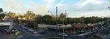
Belgrave has galleries and bookshops. The most notable bookshop would have to be The Belgrave Book Barn, located right next to the Cameo Theatre. There is an organic and fair trade emphasis amongst some businesses including Belgrave Organics, at least three cafés serving fairtrade coffee (Earthly Pleasures Organic Café, Café Green Bean and Reel Café). There are two retro clothing stores (Walk in Wardrobe and The Silver Compac). There is a Safeway supermarket, three hairdressing salons, a travel agency, a building design (drafting) service, a pharmacy, a butcher, a dry cleaner, three bakeries, a newsagency, a cinema, a few fast food outlets, restaurants, a Centrelink
centre, a pub and a few bars/lounges, two banks (the Commonwealth Bank and the Bendigo Bank
) as well as a public library. It also has a very active Traders Association. JB Hi-Fi
plan to open a store in Belgrave between 2012 and 2014.
 An attraction is the heritage
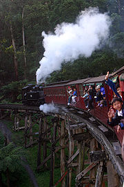
narrow gauge, steam-operated Puffing Billy Railway, which was reopened in 1962—after four years of restoration by volunteers—and travels through 24 kilometres of cool temperate rainforest, semi-urban development and rural farmland. It is also the terminus of the Belgrave Suburban Electric Railway Line.
Other nearby attractions include The 1000 Steps, Sherbrooke Forest
and Sherbrooke Falls in the Dandenong Ranges National Park
.
The Cameo Cinema has six cinemas, with Cinema 1 dating to the 1930s. There is an outdoor Cinema at the rear of the building, which is open only during the summer months (December to March). There is a music scene with live acts taking place at Rubys Lounge and the Scarab Bar. There is a recording studio. The historic property known as Glen Harrow Gardens has been featured on travel television programs.
, Selby
and Belgrave South
. Upwey High School is the nearest state high school.
Two Catholic schools operate within Belgrave: St Thomas More's Primary School that was founded in 1963 by the parish of Belgrave, and is situated on Reynolds hill overlooking Belgrave and adjacent to St. Thomas More's Catholic Church, and Mater Christi College
, a girls' secondary school located on Bayview Road.
There is a Centrelink
office on the high side of Main Street. The State Member for the seat of Monbulk, James Merlino
MLA, has his Electoral Office in Belgrave. The closest Shire of Yarra Ranges
office is in Upwey
on Main Street.
The Belgrave Town Park, just below the police station, provides a fine view over the town as well as a public space for events such as the annual Christmas carols. Just off the Belgrave-Hallam Road is the Belgrave outdoor swimming pool, tennis courts and a playground.
The town supports both a cricket and Australian Rules football team which are located at Belgrave Recreation Reserve on Reserve Road. The Belgrave Cricket Club is affiliated with the Ferntree Gully And District Cricket Association, while the Belgrave Football Club competes in the Yarra Valley Mountain Football League.
. Puffing Billy goes to Gembrook via Emerald
Bus services are located throughout the suburb, and go to Oakleigh
, Ringwood
, Lilydale
, Box Hill
, Emerald
, Glen Waverley
, Olinda
, Monbulk
and Knox City Shopping Centre
. There are also many extremely local buses that go to very nearby places like Belgrave South
, Upwey
and Ferntree Gully
.
Major roads include Burwood Highway
and EastLink
, Wellington Road, Ferntree Gully Road and Belgrave-Hallam Road, all providing access to the city centre of Melbourne
.
and Water Rat
. In the trees, arboreal mammals include the Sugar Glider
and also would have been a habitat for the Yellow-bellied Glider.
Belgrave Lake was constructed in 1893 to supply water to Dandenong. Water flowed by pipeline to Heany Park in Rowville and then by aqueduct and pipeline through Churchill Park and on to Dandenong. From 1924 water supply to Dandenong was discontinued but the pipeline continued to supply water to farms in the Lysterfield area. Fern Tree Gully Shire leased the pipeline from 1940 to 1950. The pipeline was still in use in the 1970s and was closed some time after that.
on 97.1FM.
Melbourne
Melbourne is the capital and most populous city in the state of Victoria, and the second most populous city in Australia. The Melbourne City Centre is the hub of the greater metropolitan area and the Census statistical division—of which "Melbourne" is the common name. As of June 2009, the greater...
, Victoria
Victoria (Australia)
Victoria is the second most populous state in Australia. Geographically the smallest mainland state, Victoria is bordered by New South Wales, South Australia, and Tasmania on Boundary Islet to the north, west and south respectively....
, Australia
Australia
Australia , officially the Commonwealth of Australia, is a country in the Southern Hemisphere comprising the mainland of the Australian continent, the island of Tasmania, and numerous smaller islands in the Indian and Pacific Oceans. It is the world's sixth-largest country by total area...
, 35 km east from Melbourne's central business district
Melbourne city centre
Melbourne City Centre is an area of Melbourne in Victoria, Australia. It is not to be confused with the larger local government area of the City of Melbourne...
. Its Local Government Area is the Shire of Yarra Ranges
Shire of Yarra Ranges
The Yarra Ranges Shire is a Local Government Area in Victoria, Australia, located in the outer eastern and northeastern suburbs of Melbourne extending into the Yarra Valley and Dandenong Ranges...
. At the 2006 Census, Belgrave had a population of 4094. Belgrave is only 16 years younger than Melbourne CBD.
History
Belgrave was first settled in 1851.Belgrave was named after an 1840s chapel in Leeds, Yorkshire, England; the name carried by Mr and Mrs R.G. Benson when they came to Melbourne in 1856. Their sons, the Benson Brothers, settled in the Belgrave district in the 1870s. A Post Office opened in the area around 1904. Many men from Belgrave went to war, and there is a war memorial in Belgrave.
Business
Most of the commercial district of Belgrave is located on Main Street, which is at the end of Burwood HighwayBurwood Highway
Burwood Highway is a major transportation link with Melbourne's eastern suburbs. It begins in the suburb of Kooyong, Melbourne at the junction of the Monash Freeway as Toorak Road between Monash Freeway and Warrigal Road, and finishes in Belgrave, Victoria in the Dandenong Ranges...
. There are also shops on Bayview Road, which is located just across the rail bridge.
Belgrave has galleries and bookshops. The most notable bookshop would have to be The Belgrave Book Barn, located right next to the Cameo Theatre. There is an organic and fair trade emphasis amongst some businesses including Belgrave Organics, at least three cafés serving fairtrade coffee (Earthly Pleasures Organic Café, Café Green Bean and Reel Café). There are two retro clothing stores (Walk in Wardrobe and The Silver Compac). There is a Safeway supermarket, three hairdressing salons, a travel agency, a building design (drafting) service, a pharmacy, a butcher, a dry cleaner, three bakeries, a newsagency, a cinema, a few fast food outlets, restaurants, a Centrelink
Centrelink
Centrelink is the trading name of the Commonwealth Service Delivery Agency , a statutory authority responsible for delivering human services on behalf of agencies of the Commonwealth Government of Australia. The majority of Centrelink's services are the disbursement of social security payments...
centre, a pub and a few bars/lounges, two banks (the Commonwealth Bank and the Bendigo Bank
Bendigo Bank
Bendigo Bank is an Australian financial institution, operating primarily in retail banking. The company merged with Adelaide Bank in November 2007, with shareholders voting in March 2008 to change the merged company’s name to Bendigo and Adelaide Bank Limited.Before the merger, Bendigo Bank...
) as well as a public library. It also has a very active Traders Association. JB Hi-Fi
JB Hi-Fi
JB Hi-Fi is an Australian CD, DVD, Blu-ray disc, video game and consumer electronics chain store.-History:JB Hi-Fi was established in Melbourne suburb of Keilor East by John Barbuto in 1974...
plan to open a store in Belgrave between 2012 and 2014.
Tourism
Cultural heritage
Cultural heritage is the legacy of physical artifacts and intangible attributes of a group or society that are inherited from past generations, maintained in the present and bestowed for the benefit of future generations...
narrow gauge, steam-operated Puffing Billy Railway, which was reopened in 1962—after four years of restoration by volunteers—and travels through 24 kilometres of cool temperate rainforest, semi-urban development and rural farmland. It is also the terminus of the Belgrave Suburban Electric Railway Line.
Other nearby attractions include The 1000 Steps, Sherbrooke Forest
Sherbrooke Forest
Sherbrooke Forest lies at an altitude of 300 m within the Dandenong Ranges, 40 km east of Melbourne, in Victoria, Australia, close to the suburb of Belgrave. The vegetation is classified as wet sclerophyll forest with the dominant tree species the Mountain Ash, Eucalyptus regnans, the tallest...
and Sherbrooke Falls in the Dandenong Ranges National Park
Dandenong Ranges National Park
Dandenong Ranges National Park is in Victoria, Australia, 38 km east of Melbourne.Because the park is located in an urban area, the park has a long history of major problems with feral and roaming animals...
.
Social scene
Belgrave has a park 3 km from the Main Street.The Cameo Cinema has six cinemas, with Cinema 1 dating to the 1930s. There is an outdoor Cinema at the rear of the building, which is open only during the summer months (December to March). There is a music scene with live acts taking place at Rubys Lounge and the Scarab Bar. There is a recording studio. The historic property known as Glen Harrow Gardens has been featured on travel television programs.
Schools
Belgrave itself does not contain any state schools, with these being located in the neighbouring suburbs of TecomaTecoma, Victoria
Tecoma is a suburb in Melbourne, Victoria, Australia, 34 km east from Melbourne's central business district. Its Local Government Area is the Shire of Yarra Ranges...
, Selby
Selby, Victoria
Selby is a suburb in Melbourne, Victoria, Australia, 37 km south-east from Melbourne's central business district. Its Local Government Area is the Shire of Yarra Ranges...
and Belgrave South
Belgrave South, Victoria
Belgrave South is a locality within, and a suburb of, Greater Melbourne mainly beyond the Melbourne metropolitan area Urban Growth Boundary, 39 km south-east from Melbourne's central business district. Its Local Government Area is the Shire of Yarra Ranges. At the 2006 Census, Belgrave South...
. Upwey High School is the nearest state high school.
Two Catholic schools operate within Belgrave: St Thomas More's Primary School that was founded in 1963 by the parish of Belgrave, and is situated on Reynolds hill overlooking Belgrave and adjacent to St. Thomas More's Catholic Church, and Mater Christi College
Mater christi college
Mater Christi is a Catholic girls' secondary college located in the eastern Melbourne suburb of Belgrave, Victoria, Australia.The school was founded by the Sisters of the Good Samaritan religious order in 1963 outside Belgrave, overlooking the Dandenong Ranges of Victoria...
, a girls' secondary school located on Bayview Road.
Recreation and Government buildings
Belgrave has a state of the art Police Station, which acts as the base for all police stations in the Dandenong Ranges Region. There is also the Belgrave Volunteer Fire Brigade on Bayview Road, which has been serving the community for over 80 years. It is also home to the Dandenong Ranges Fire Brigades Group HQ, which manages all major fires within the Dandenong Ranges. There is also an Ambulance station in Bayview Road.There is a Centrelink
Centrelink
Centrelink is the trading name of the Commonwealth Service Delivery Agency , a statutory authority responsible for delivering human services on behalf of agencies of the Commonwealth Government of Australia. The majority of Centrelink's services are the disbursement of social security payments...
office on the high side of Main Street. The State Member for the seat of Monbulk, James Merlino
James Merlino
James Anthony Merlino is an Australian politician serving as the member for Monbulk in the Victorian Legislative Assembly, as a member of the Australian Labor Party.Merlino was elected at the 2002 state election defeating Steve McArthur...
MLA, has his Electoral Office in Belgrave. The closest Shire of Yarra Ranges
Shire of Yarra Ranges
The Yarra Ranges Shire is a Local Government Area in Victoria, Australia, located in the outer eastern and northeastern suburbs of Melbourne extending into the Yarra Valley and Dandenong Ranges...
office is in Upwey
Upwey, Victoria
Upwey is a suburb in Melbourne, Victoria, Australia, east from Melbourne's central business district. Its Local Government Area is the Shire of Yarra Ranges and City of Knox. At the 2006 Census, Upwey had a population of 6,760.-History:...
on Main Street.
The Belgrave Town Park, just below the police station, provides a fine view over the town as well as a public space for events such as the annual Christmas carols. Just off the Belgrave-Hallam Road is the Belgrave outdoor swimming pool, tennis courts and a playground.
The town supports both a cricket and Australian Rules football team which are located at Belgrave Recreation Reserve on Reserve Road. The Belgrave Cricket Club is affiliated with the Ferntree Gully And District Cricket Association, while the Belgrave Football Club competes in the Yarra Valley Mountain Football League.
Transport
Belgrave railway station is located behind the main street shops, with the steam train Puffing Billy just beyond it. Belgrave suburban electric trains go to Melbourne via RingwoodRingwood railway station, Melbourne
Ringwood is a railway station in Melbourne, Victoria, Australia, located in the suburb of Ringwood, on the Lilydale and Belgrave railway lines. It is in Metcard Zone 2, is classed as a Premium Station, and is the junction for the Belgrave & Lilydale lines....
. Puffing Billy goes to Gembrook via Emerald
Bus services are located throughout the suburb, and go to Oakleigh
Oakleigh, Victoria
Oakleigh is a suburb of Melbourne, Victoria, Australia and is located 14 km south-east from Melbourne's central business district. Its Local Government Area is the City of Monash. At the 2006 Census, Oakleigh had a population of 6,876....
, Ringwood
Ringwood, Victoria
Ringwood is a suburb in Melbourne, Victoria, Australia, east of Melbourne's central business district. Its Local Government Area is the City of Maroondah. At the 2006 Census, Ringwood had a population of 15,185....
, Lilydale
Lilydale, Victoria
Lilydale is a suburb of Melbourne, Victoria, Australia, 35 km north-east from Melbourne's central business district situated in the Olinda Creek valley. At the 2006 Census, Lilydale had a population of 13,887...
, Box Hill
Box Hill, Victoria
Box Hill is a suburb in Melbourne, Victoria, Australia, 14 km east from Melbourne's central business district. Its Local Government Area is the City of Whitehorse. At the 2006 Census, Box Hill had a population of 8,616....
, Emerald
Emerald, Victoria
Emerald is a town and semi-rural locality in the Greater Melbourne area, Victoria, Australia, 44 km south-east from Melbourne's central business district, outside the urban area. Its Local Government Area are the Shires of Cardinia and Yarra Ranges...
, Glen Waverley
Glen Waverley, Victoria
Glen Waverley is a suburb in Melbourne, Victoria, Australia, 19 km south-east from Melbourne's central business district. Its Local Government Area is the City of Monash...
, Olinda
Olinda, Victoria
Olinda is a suburb in Melbourne, Victoria, Australia, 36 km east from Melbourne's central business district. Its Local Government Area is the Shire of Yarra Ranges. At the 2006 Census, Olinda had a population of 1568.-History:...
, Monbulk
Monbulk, Victoria
Monbulk is a satellite town & suburb of Melbourne located 42 km east from Melbourne's central business district. Its Local Government Area is the Shire of Yarra Ranges. At the 2006 Census, Monbulk had a population of 2715.-History:...
and Knox City Shopping Centre
Knox City Shopping Centre
Knox City Shopping Centre is a super-regional shopping centre and outdoor entertainment complex located in the outer eastern suburb of Wantirna South in the city of Melbourne, Australia. The centre opened on November 9, 1977 with an initial 88 stores and 2300 parking spaces...
. There are also many extremely local buses that go to very nearby places like Belgrave South
Belgrave South, Victoria
Belgrave South is a locality within, and a suburb of, Greater Melbourne mainly beyond the Melbourne metropolitan area Urban Growth Boundary, 39 km south-east from Melbourne's central business district. Its Local Government Area is the Shire of Yarra Ranges. At the 2006 Census, Belgrave South...
, Upwey
Upwey, Victoria
Upwey is a suburb in Melbourne, Victoria, Australia, east from Melbourne's central business district. Its Local Government Area is the Shire of Yarra Ranges and City of Knox. At the 2006 Census, Upwey had a population of 6,760.-History:...
and Ferntree Gully
Ferntree Gully, Victoria
Ferntree Gully is a suburb in Melbourne, Victoria, Australia, in the Dandenong Ranges, 29 km east from Melbourne's central business district. It is in the Local Government Area's of the Shire of Yarra Ranges and the City of Knox...
.
Major roads include Burwood Highway
Burwood Highway
Burwood Highway is a major transportation link with Melbourne's eastern suburbs. It begins in the suburb of Kooyong, Melbourne at the junction of the Monash Freeway as Toorak Road between Monash Freeway and Warrigal Road, and finishes in Belgrave, Victoria in the Dandenong Ranges...
and EastLink
Eastlink
Eastlink may refer to:* EastLink , a toll road in Melbourne, Australia* East-Link , a toll bridge in Dublin, Ireland* EastLink , a communications provider in Canada...
, Wellington Road, Ferntree Gully Road and Belgrave-Hallam Road, all providing access to the city centre of Melbourne
Melbourne
Melbourne is the capital and most populous city in the state of Victoria, and the second most populous city in Australia. The Melbourne City Centre is the hub of the greater metropolitan area and the Census statistical division—of which "Melbourne" is the common name. As of June 2009, the greater...
.
Public reserves
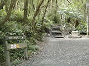
Public reserves in Belgrave include Belgrave Lake Park, Belgrave Recreation Reserve, Borthwick Park, Violet Larsen Reserve and Dandenong Ranges National Park.Belgrave Lake Park
A small reserve surrounding Belgrave Lake and located south of Belgrave town centre. It is an important biolink between Dandenong Ranges National Park and Birdsland as well as Lysterfield Lake Park. The park has a combined focus of recreation and conservation. Monbulk creek flows through the area and is important for wildlife such as PlatypusPlatypus
The platypus is a semi-aquatic mammal endemic to eastern Australia, including Tasmania. Together with the four species of echidna, it is one of the five extant species of monotremes, the only mammals that lay eggs instead of giving birth to live young...
and Water Rat
Water Rat
Water Rat may refer to:AnimalsWater Rat is a common name for several unrelated semiaquatic rodents, including:*European Water Vole, found in north and central Europe and Russia*Rakali, found in Australia and New Guinea...
. In the trees, arboreal mammals include the Sugar Glider
Sugar Glider
The sugar glider is a small gliding possum originating from the marsupial family.The sugar glider is native to eastern and northern mainland Australia and is also native to New Guinea and the Bismarck Archipelago.- Habitat :Sugar gliders can be found all throughout the northern and eastern parts of...
and also would have been a habitat for the Yellow-bellied Glider.
Belgrave Lake was constructed in 1893 to supply water to Dandenong. Water flowed by pipeline to Heany Park in Rowville and then by aqueduct and pipeline through Churchill Park and on to Dandenong. From 1924 water supply to Dandenong was discontinued but the pipeline continued to supply water to farms in the Lysterfield area. Fern Tree Gully Shire leased the pipeline from 1940 to 1950. The pipeline was still in use in the 1970s and was closed some time after that.
Media
Belgrave's local newspapers are The Free Press Leader, and The Ferntree Gully-Belgrave Mail and its local radio station is 3MDR3mdr
3MDR is one of many Community radio stations which broadcast in Melbourne, Victoria, Australia. It covers the Shire of Yarra Ranges and Shire of Cardinia. With the Studio and transmitter located in Emerald...
on 97.1FM.