
Dandenong Ranges National Park
Encyclopedia
Victoria (Australia)
Victoria is the second most populous state in Australia. Geographically the smallest mainland state, Victoria is bordered by New South Wales, South Australia, and Tasmania on Boundary Islet to the north, west and south respectively....
, Australia, 38 km east of Melbourne.
Because the park is located in an urban area, the park has a long history of major problems with feral and roaming animals. A cat
Feral cat
A feral cat is a descendant of a domesticated cat that has returned to the wild. It is distinguished from a stray cat, which is a pet cat that has been lost or abandoned, while feral cats are born in the wild; the offspring of a stray cat can be considered feral if born in the wild.In many parts of...
-curfew
Curfew
A curfew is an order specifying a time after which certain regulations apply. Examples:# An order by a government for certain persons to return home daily before a certain time...
was introduced in the entire Dandenong Ranges
Dandenong Ranges
The Dandenong Ranges are a set of low mountain ranges, rising to 633 metres at Mount Dandenong, approximately 35 km east of Melbourne, Victoria, Australia...
area some years ago, and since then the numbers and variety of lyrebird
Lyrebird
A Lyrebird is either of two species of ground-dwelling Australian birds, that form the genus, Menura, and the family Menuridae. They are most notable for their superb ability to mimic natural and artificial sounds from their environment. Lyrebirds have unique plumes of neutral coloured...
s and other native species have climbed dramatically.
Dandenong Ranges National Park is divided into five sections:
- Doongalla Forest – Containing Mount Dandenong itself, and the SkyHigh lookout with panoramic views of Melbourne's east.
- Ferntree Gully – The south western section of the Dandenong Ranges National Park, located between the suburbs of Ferntree Gully and BoroniaBoronia, VictoriaBoronia is a suburb in Melbourne, Victoria, Australia, 29 km east from Melbourne's central business district. Its Local Government Area is the City of Knox...
to the west, UpweyUpwey, VictoriaUpwey is a suburb in Melbourne, Victoria, Australia, east from Melbourne's central business district. Its Local Government Area is the Shire of Yarra Ranges and City of Knox. At the 2006 Census, Upwey had a population of 6,760.-History:...
to the south, TremontTremont, VictoriaTremont is a suburb in Melbourne, Victoria, Australia, 31 km south-east from Melbourne's central business district. Its Local Government Area is the Shire of Yarra Ranges...
and SassafrasSassafras, VictoriaSassafras is a locality and township within Greater Melbourne beyond the Melbourne metropolitan area Urban Growth Boundary, 43 km east from Melbourne's central business district. Its Local Government Area is the Shire of Yarra Ranges. At the 2006 Census, Sassafras had a population of 968...
to the east and The BasinThe Basin, VictoriaThe Basin is a suburb in Melbourne, Victoria, Australia, 31 km east from Melbourne's central business district. Its Local Government Area is the City of Knox...
to the north. The park contains the Thousands Steps trail leading to One Tree Hill. The very steep walking trail includes over 700 steps over 2.5km and commemorates the battle for the Kokoda trackKokoda TrackThe Kokoda Trail or Track is a single-file foot thoroughfare that runs overland — in a straight line — through the Owen Stanley Range in Papua New Guinea...
in Territory of Papua during World War IINew Guinea campaignThe New Guinea campaign was one of the major military campaigns of World War II.Before the war, the island of New Guinea was split between:...
. The steps are a popular destination for sightseers and fitness enthusiasts alike. During the AFLAustralian Football LeagueThe Australian Football League is both the governing body and the major professional competition in the sport of Australian rules football...
pre-season a number of Melbourne Australian Rules football League and Association teams run their players up the steps to promote team fitness. There is no specific creation date of the steps, however they are believed to be built during the early 1860s when they provided the only means of accessing the One Tree Hill Summit. According to a Tourist Guide published in 1868, all other areas contained thick forest vegetation. A survey of the park found that over 82% of visitors (on weekends) use the park for fitness-related walking. It is also a popular spot for picnics.
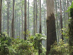
- Sherbrooke ForestSherbrooke ForestSherbrooke Forest lies at an altitude of 300 m within the Dandenong Ranges, 40 km east of Melbourne, in Victoria, Australia, close to the suburb of Belgrave. The vegetation is classified as wet sclerophyll forest with the dominant tree species the Mountain Ash, Eucalyptus regnans, the tallest...
- Olinda Forest occupies the eastern slopes of Mount Dandenong.
- Mount Evelyn Forest is the most northerly section of the park.