
Beerangali
Encyclopedia
Beeran Gali is a Union Council
of Abbottabad District
, in Khyber-Pakhtunkhwa province of Pakistan
. located approximately 20 km from Abbottabad
city.
and Miranjani
. It is located at 34°11'40N 73°21'50E and has an average elevation of 2176 metres (7142 feet) above sea-level.
Andarseri, Beerangali and Jhafar.
or 'Kiraal' and the Quraishi
. In popular local lore, the inhabitants of this area are particularly courageous. According to the author of Hazra Gazetteers, the people of this area had not accepted the British rule, and were found to be most resistant till 1947.
There are two high schools, one each for boys and girls as well as numerous middle and primary schools.
Union Councils of Pakistan
A sherwan or village council in Pakistan is an elected local government body consisting of 21 councillors, and headed by a nazim and a naib nazim...
of Abbottabad District
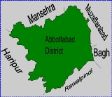
Abbottabad District
Abbottabad is a district in the Khyber Pakhtunkhwa province of Pakistan. The district covers an area of 1,969 km with the city of Abbottabad being the principal town...
, in Khyber-Pakhtunkhwa province of Pakistan
Pakistan
Pakistan , officially the Islamic Republic of Pakistan is a sovereign state in South Asia. It has a coastline along the Arabian Sea and the Gulf of Oman in the south and is bordered by Afghanistan and Iran in the west, India in the east and China in the far northeast. In the north, Tajikistan...
. located approximately 20 km from Abbottabad
Abbottabad
Abbottabad is a city located in the Hazara region of the Khyber Pakhtunkhwa province, in Pakistan. The city is situated in the Orash Valley, northeast of the capital Islamabad and east of Peshawar at an altitude of and is the capital of the Abbottabad District...
city.
History
This area was historically known as Baad Burhan and is mentioned by Al Biruni in his famous book Ta'rikh al-Hind, The Chronicles of India, from 1030. Al Biruni describes Baad Burhan as a beautiful area.Topography
The area is situated between two mountains, ThandianiThandiani
Thandiani is a hill station in the Galyat area of Pakistan.-History:Thandiani was established as a Sanatorium during British rule, for the convenience of officers stationed at the neighbouring cantonment of Abbottabad, it contained some European houses and a small bazaar, which were occupied only...
and Miranjani
Miranjani
Miranjani is the highest peak, at in elevation, of Abbottabad District in the Khyber Pakhtunkhwa Province of Pakistan. It is located in the Namli Maira area, in Ayubia National Park, north of Islamabad in the western Himalayan range....
. It is located at 34°11'40N 73°21'50E and has an average elevation of 2176 metres (7142 feet) above sea-level.
Subdivisions
The Union Council is subdivided into the following areas:Andarseri, Beerangali and Jhafar.
Demographics
Its population numbers about 12,300. Ethnically, the two main tribes are the KarlalKarlal
The Karlal are a tribe found in the Abbottabad and Haripur districts of Khyber-Pakhtunkhwa province of Pakistan...
or 'Kiraal' and the Quraishi
Quraishi
Quraishi , is a family name that originates from Arabs in Saudi Arabia, particularly from the city of Mecca.- Lineage :...
. In popular local lore, the inhabitants of this area are particularly courageous. According to the author of Hazra Gazetteers, the people of this area had not accepted the British rule, and were found to be most resistant till 1947.
There are two high schools, one each for boys and girls as well as numerous middle and primary schools.