

Bear Camp Road
Encyclopedia
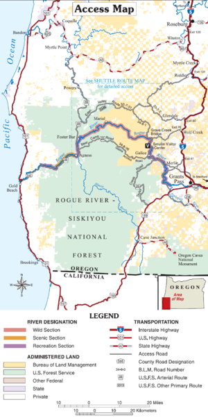
Klamath Mountains
The Klamath Mountains, which include the Siskiyou, Marble, Scott, Trinity, Trinity Alps, Salmon, and northern Yolla-Bolly Mountains, are a rugged lightly populated mountain range in northwest California and southwest Oregon in the United States...
in Josephine and Curry
Curry County, Oregon
Curry County is a county located in the U.S. state of Oregon. In 2010, its population was 22,364. The county is named for George Law Curry, a governor of the Oregon Territory. The seat of the county is Gold Beach.-Economy:...
counties in the U.S. state
U.S. state
A U.S. state is any one of the 50 federated states of the United States of America that share sovereignty with the federal government. Because of this shared sovereignty, an American is a citizen both of the federal entity and of his or her state of domicile. Four states use the official title of...
of Oregon
Oregon
Oregon is a state in the Pacific Northwest region of the United States. It is located on the Pacific coast, with Washington to the north, California to the south, Nevada on the southeast and Idaho to the east. The Columbia and Snake rivers delineate much of Oregon's northern and eastern...
. Bear Camp Road is a combination of Bureau of Land Management
Bureau of Land Management
The Bureau of Land Management is an agency within the United States Department of the Interior which administers America's public lands, totaling approximately , or one-eighth of the landmass of the country. The BLM also manages of subsurface mineral estate underlying federal, state and private...
(BLM) Road 34-8-36 (also known as Galice Road) starting just south of Galice
Galice, Oregon
Galice is an unincorporated community in Josephine County in Southern Oregon, United States.-History:Galice was officially settled in 1852 as a mining community, deriving its name from one of its founders, Louis Galice. It was at first called Galiceburg, and located on Galice Creek upstream from...
and United States Forest Service
United States Forest Service
The United States Forest Service is an agency of the United States Department of Agriculture that administers the nation's 155 national forests and 20 national grasslands, which encompass...
(FS) Road 23, which continues from the 12 miles (19.3 km) point on 34-8-36 to Agness
Agness, Oregon
Agness is an unincorporated community in Curry County, Oregon, United States. It is located near the confluence of two Wild and Scenic rivers—the Lower Rogue and the Illinois. Agness post office was established October 16, 1897. It was named after Agnes, the daughter of the first postmaster, and...
. The road is named for a camp and viewpoint at the 4600 feet (1,402.1 m) summit near the Josephine/Curry county line.
The road is a common route to recreational opportunities, including hunting and rafting, and is also the only route to the Oregon Coast
Oregon Coast
The Oregon Coast is a region of the U.S. state of Oregon. It runs generally north-south along the Pacific Ocean, forming the western border of the state; the region is bounded to the east by the Oregon Coast Range. The Oregon Coast stretches approximately from the Columbia River in the north to...
between the California-Oregon border and the Rogue River
Rogue River (Oregon)
The Rogue River in southwestern Oregon in the United States flows about in a generally westward direction from the Cascade Range to the Pacific Ocean. Known for its salmon runs, whitewater rafting, and rugged scenery, it was one of the original eight rivers named in the Wild and Scenic Rivers Act...
. It is a paved, one-lane road with infrequent turnouts and a few gravel sections. At both ends, the road quickly climbs up to the crest of the Coast Range, and the majority of the road is at high elevation on top of a long ridge.
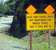
Bear Camp Road is a rugged, narrow, crooked road, which is not suitable for travel in the winter. Numerous motorists have been stranded for days or weeks on Bear Camp Road or one of the many gravel roads that branch off from it. Dewitt Finley and James Kim
James Kim
James Kim was an American television personality and technology analyst for the former TechTV international cable television network, reviewing products for shows including The Screen Savers, Call for Help, and Fresh Gear...
both died after being stranded on the road in winter.
Kim family ordeal
Bear Camp Road came into the national spotlight in late 2006 when James Kim, his wife Kati, and their two daughters attempted to reach Gold BeachGold Beach, Oregon
Gold Beach is a city in and the county seat of Curry County, Oregon, United States, on the Oregon Coast. The population was 1,897 at the 2000 census.-History:...
via this route. They missed an Interstate 5 exit to their intended route, Oregon Route 42, and decided to take Bear Camp Road instead. Late on the night of November 25, 2006, they missed signs warning of possible snow and continued up the mountain road. At the intersection of the BLM and FS sections of the road, they accidentally turned off of Bear Camp Road and eventually ended up lost 16 miles (25.7 km) down an unpaved side road before stopping for the night. A snowstorm trapped them at this location.
The family waited for rescue, surviving on limited resources. After spending six days waiting for rescue, James Kim left the car to seek help. He and his wife had attempted to locate their position using area road maps, and had estimated that the small town of Galice, Oregon was only four miles away. They were actually 33 miles (53.1 km) from the town by road.
He left the car at 7:30 a.m. on Saturday, December 2 and backtracked down the road on which they were stranded. Approximately 11 miles (17.7 km) down the road, he turned down into the Big Windy Creek canyon. James Kim hiked through treacherous and dangerous terrain to reach the creek, and apparently was attempting to follow it to the Rogue River in an attempt to find help.
On the following Monday, searchers found Kati Kim and her children near the car, but could not locate James Kim. Searchers traced James Kim's path down Big Windy Creek’s canyon in an effort to find him. His body was recovered in Big Windy Creek on Wednesday, December 6. According to medical examiners, James Kim died of hypothermia
Hypothermia
Hypothermia is a condition in which core temperature drops below the required temperature for normal metabolism and body functions which is defined as . Body temperature is usually maintained near a constant level of through biologic homeostasis or thermoregulation...
, but a precise time of death was not known. He had walked approximately 16 miles (25.7 km) trying to find help.
Initial reports from government officials contained incorrect information about the position of the Kims' car and its proximity to the location where James Kim's body was found. It was first thought that the Kims' car was stranded at the intersection to the access road for Black Bar Lodge (42°39′1.25"N 123°44′54.15"W). They were actually six miles from this shelter. Mapping errors caused this miscalculation, according to officials. The actual location was: 42.690430°N 123.776577°W
Following the conclusion of the search and recovery efforts, government officials confirmed that a gate blocking access to the road on which the Kims were stranded should have been locked, but was not. Bureau of Land Management employees dispatched to close the gate had decided against locking the gate due to the possibility of hunters being stranded inside.
Since the incident, the Forest Service and Bureau of Land Management has installed additional numerous large signs on the approaches to Bear Camp Road, warning that the road may be impassible during winter months. Also, the directional sign ("To Gold Beach and Coast") at the spot where the Kims turned onto the wrong road, has been moved and replaced. At the spot, the paved through road is narrow and steeply uphill while the gravel side road is much wider and more level. The location and arrow direction on the old sign was confusing and ambiguous, especially in snow when it would be impossible to see that the narrow uphill road is paved while the wide level road is not.
Previous incidents
DeWitt Finley
In 1994, a man traveling over Bear Camp Road died after being stranded for nine weeks. The victim, Dewitt Finley, was a camper salesman from MontanaMontana
Montana is a state in the Western United States. The western third of Montana contains numerous mountain ranges. Smaller, "island ranges" are found in the central third of the state, for a total of 77 named ranges of the Rocky Mountains. This geographical fact is reflected in the state's name,...
. He was attempting to drive from Gold Beach to Grants Pass
Grants Pass, Oregon
-Rogue River:The Rogue River runs through Grants Pass.-Demographics:As of the census of 2000, there were 23,003 people, 9,376 households, and 5,925 families residing in the city. The population density was . There were 9,885 housing units at an average density of 1,303.3 per square mile . By 2008,...
and became snowbound. He kept a journal while stranded on the road, and ultimately died of starvation. His body wasn't recovered until May 1995, when it was discovered by a group of local teenagers. There is no indication that Finley ever attempted to hike out, or ever left his camper. Some accounts indicate that Finley would have likely survived if he had attempted to hike out.
In his journal, Finley wrote, "I have no control over my life its all in His Hands. 'His will be done.' Death here in another month or so, or He sends someone to save me", leading some to speculate that he looked to divine intervention and his strong religious devotion to save him, or that other psychological/emotional factors led him to "give up."
The Stivers
In March 2006 six members of an Ashland, OregonAshland, Oregon
Ashland is a city in Jackson County, Oregon, United States, near Interstate 5 and the California border, and located in the south end of the Rogue Valley. It was named after Ashland County, Ohio, point of origin of Abel Helman and other founders, and secondarily for Ashland, Kentucky, where other...
family were stranded in their snowbound motor home for two weeks. In addition to the two Stivers, the group included Stivers's parents, the Higginbothams; and the Stivers' two children. The RV was stranded on the spur road to Calvert Airstrip near its intersection with the BLM Glendale-to-Powers Bike Route after that road passes Marial Junction, about 15 miles (24.1 km) west of Glendale. Unlike the route of James Kim and his family who turned west up BLM 34-8-36 toward Bear Camp Road and Gold Beach, the Stivers-Higginbotham group took a different road, having missed the turnoff that the Kims took toward Bear Camp at the start of BLM 34-8-36. Stivers-Higginbotham's route went north through Galice and on to Grave Creek, there crossing the bridge over the Rogue River, and next, heading north up Mount Reuben Road. When they got to the Glendale-to-Powers bike route, they turned west where they later became stuck in snow on the BLM airstrip spur, while trying to head back down it after turning around at the airstrip. Their RV had become stuck north of the Rogue River in March, about seven miles (11 km) NNE, geographically, from where the Kims car was stranded in late November 2006.
Confusion about the whereabouts and intentions of the group caused law enforcement officials to call off their search after five days. Police had received conflicting information on the group's destination, and some officials considered treating the case as a kidnapping.
Inside the motor home, the family was able to see television news reports of the search effort, but became convinced that rescuers would not find them. Two of the six in the group hiked out to search for the searchers, and were found (by accident) by Bureau of Land Management employees on routine patrol. The other members of the group were rescued later that day. All were in good condition.
Family members Elbert and Becky Higginbotham were quickly arrested after Arizona officials filed warrants charging the Higginbothams with possessing methamphetamine for sale and other crimes there.
Elbert Higginbotham also faced a felony count of possession or use of a weapon in a drug offense. Becky Higginbotham, who was listed in the warrant as Rebecca Ann Bess, was also charged with possession of drug paraphernalia.