
Bass Coast Shire
Encyclopedia
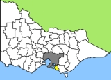
Bass Coast Shire is a Local Government Area in Victoria, Australia. It is located in the south-eastern part of the state, less than 90 minutes from Melbourne
, and includes the popular tourist destination, Phillip Island. It has an area of 859 square kilometres and has an estimated population
of 29,581 people.
It was formed in December 1994 from the merger of the Shire of Bass
, Shire of Phillip Island
, Borough of Wonthaggi
and parts of the Shire of Woorayl
, Shire of Korumburra
and Shire of Cranbourne.
Each ward is represented by one elected Councillor.
Melbourne
Melbourne is the capital and most populous city in the state of Victoria, and the second most populous city in Australia. The Melbourne City Centre is the hub of the greater metropolitan area and the Census statistical division—of which "Melbourne" is the common name. As of June 2009, the greater...
, and includes the popular tourist destination, Phillip Island. It has an area of 859 square kilometres and has an estimated population
Population
A population is all the organisms that both belong to the same group or species and live in the same geographical area. The area that is used to define a sexual population is such that inter-breeding is possible between any pair within the area and more probable than cross-breeding with individuals...
of 29,581 people.
It was formed in December 1994 from the merger of the Shire of Bass
Shire of Bass
The Shire of Bass was a Local Government Area located about south-southeast of Melbourne, the state capital of Victoria, Australia. The shire covered an area of , and existed from 1871 until 1994...
, Shire of Phillip Island
Shire of Phillip Island
The Shire of Phillip Island was a Local Government Area located in Western Port about south of Melbourne, the state capital of Victoria, Australia. The shire covered an area of , and existed from 1928 until 1994.-History:...
, Borough of Wonthaggi
Borough of Wonthaggi
The Borough of Wonthaggi was a Local Government Area located about south-southeast of Melbourne, the state capital of Victoria, Australia. The borough covered an area of , and existed from 1911 until 1994...
and parts of the Shire of Woorayl
Shire of Woorayl
The Shire of Woorayl was a Local Government Area located about southeast of Melbourne, the state capital of Victoria, Australia. The shire covered an area of , and existed from 1888 until 1994.-History:...
, Shire of Korumburra
Shire of Korumburra
The Shire of Korumburra was a Local Government Area located about southeast of Melbourne, the state capital of Victoria, Australia. The shire covered an area of , and existed from 1891 until 1994.-History:...
and Shire of Cranbourne.
Towns and suburbs
- AlmurtaAlmurta, VictoriaAlmurta is a small town in Victoria, Australia. It is located along Glen Alvie Road, in the Bass Coast Shire, 107 kilometres south east of Melbourne. A full Post Office opened here on 21 April 1914 but was closed in 1969....
- AndersonAnderson, VictoriaAnderson is a locality in Victoria, Australia. The roundabout which the locality is centralised around has been named the Anderson Roundabout which is all the town is thought of today....
- Archies CreekArchies Creek, VictoriaArchies Creek is a small town in Victoria, Australia. It is located on Dalyston - Korumburra Road, in the Bass Coast Shire, north-west of Wonthaggi.The Post Office, Archie's Creek, opened on 17 November 1899 and closed in 1986....
- BassBass, VictoriaBass is a small rural town 113 kilometres south-east of Melbourne via the South Gippsland and Bass Highways, in the Bass Coast Shire of Gippsland, Victoria, Australia...
- CorinellaCorinella, VictoriaCorinella is a town in Victoria, Australia, located 114 km south-east of Melbourne via the M1 and the Bass Highway, on the eastern shore of Western Port Bay...
- Coronet Bay
- CowesCowes, VictoriaCowes is the main township on Phillip Island in the Gippsland region of Victoria, Australia. It is less than 2 hours drive from Melbourne and can also be reached by ferry from Stony Point on the Mornington Peninsula. Cowes is located on the northern side of Phillip Island and faces towards French...
- Dalyston
- Glen Alvie
- Glen Forbes
- GrantvilleGrantville, VictoriaGrantville is a small town in Victoria, Australia. At the 2006 census, Grantville had a population of 456.The town was named after Lieutenant James Grant who surveyed the area in 1801.-History:...
- Gurdies, The
- InverlochInverloch, VictoriaInverloch is a seaside village in Victoria, Australia. It is located on the Bass Highway 143 kilometres southeast of Melbourne, at the mouth of Anderson Inlet, in the Bass Coast Shire and is located close to Australia’s southernmost stand of mangroves...
- Jam Jerrup
- Kernot
- KilcundaKilcunda, VictoriaKilcunda is a seaside town in Victoria. It is located 117 km southeast from Melbourne on the Bass Highway in the Bass Coast Shire of Gippsland, Victoria, Australia. Situated along the rugged coastline between Phillip Island and Wonthaggi, Kilcunda is well known for its popular fishing, surfing...
- KongwakKongwak, VictoriaKongwak is a small town in Victoria, Australia. It is located on the Korumburra to Wonthaggi Road southeast of Melbourne, in the South Gippsland Shire At the 2006 census, Kongwak had a population of 193.-History:...
- Krowera
- Lance Creek
- Pioneer Bay
- Pound Creek
- Ryanston
- San RemoSan Remo, VictoriaSan Remo is a town in southern Victoria, Australia in the Gippsland region. Formed as a fishing village, its economy is now more largely based around tourism. It is also notable as the town on the mainland end of the bridge to Phillip Island...
- Tenby Point
- Wattle Bank
- West Creek
- Woodleigh
- Woolamai
- WonthaggiWonthaggi, VictoriaWonthaggi is a town located south east of Melbourne via the South Gippsland and Bass Highways, in the Bass Coast Shire of Gippsland, Victoria, Australia...
- Cape PatersonCape Paterson, VictoriaCape Paterson is a cape and town in Gippsland, Victoria . The cape was named by Lieut. James Grant in 1801, honouring explorer Lieut. Col. William Paterson.At the 2006 census, Cape Paterson had a population of 674....
- Harmers Haven
- North Wonthaggi
- South Dudley
- Cape Paterson
- Phillip Island
- Cape WoolamaiCape WoolamaiCape Woolamai is a small town and headland at the south eastern tip of Phillip Island in Victoria, Australia. It is home to Cape Woolamai State Faunal Reserve, and the Phillip Island Airfield...
- CowesCowes, VictoriaCowes is the main township on Phillip Island in the Gippsland region of Victoria, Australia. It is less than 2 hours drive from Melbourne and can also be reached by ferry from Stony Point on the Mornington Peninsula. Cowes is located on the northern side of Phillip Island and faces towards French...
- NewhavenNewhaven, VictoriaNewhaven is a town in southern Victoria, in the south Gippsland region. Located on Phillip Island, adjacent to the channel known as The Narrows, it is the town on the island side of the bridge linking Phillip Island to the mainland...
- RhyllRhyll, VictoriaRhyll is a small fishing town on Phillip Island in Victoria, Australia. It is located in the north-east corner of the island. It is named after Rhyl, a holiday resort in North Wales, Great Britain. At the 2006 census, Rhyll had a population of 503....
- SilverleavesSilverleaves, VictoriaSilverleaves is a small town on Phillip Island situated east of Cowes, Victoria. At the 2006 census, Silverleaves had a population of 187.-Notes and references:...
- Summerlands
- Smiths Beach
- Sunderland Bay
- Sunset Strip
- Ventnor
- Wimbledon HeightsWimbledon Heights, VictoriaWimbledon Heights is a small town in the center of Phillip Island in Victoria, Australia. It consists of a small residential block surrounded by farmland and is located north of the Phillip Island Grand Prix track. At the 2006 census, Wimbledon Heights had a population of 386.-References:...
- Cape Woolamai
Places of interest and local events
- Australian motorcycle Grand PrixAustralian motorcycle Grand PrixThe Australian Motorcycle Grand Prix is a motorcycling event that is part of the Grand Prix motorcycle racing season. It is held each year at the scenic Phillip Island Grand Prix Circuit.-Winners of the Australian motorcycle Grand Prix:...
- Bass Coast Rail TrailBass Coast Rail TrailThe Bass Coast Rail Trail is a Rail trail located in the Bass Coast Shire of Gippsland, Victoria, Australia.The trail has been constructed along a section of the former Wonthaggi line. The trail starts at the former Anderson Station and finishes shortly after the former Wonthaggi Station...
- Phillip Island Penguin ParadePhillip Island Nature ParkPhillip Island Nature Park is a conservation park located on Phillip Island, Victoria, Australia. Created in 1996, the park is owned by the Victorian State Government, however it is a self-funding commercial attraction for the purpose of animal conservation and research.An oil spill off the island...
- Pyramid Rock FestivalPyramid Rock FestivalThe Pyramid Rock Festival is a New Year's Eve camp-out rock music festival at Pyramid Rock, Phillip Island, Victoria, Australia.Beginning in 2004, it runs over two nights with two stages - the Main Stage, and the Pharaoh's Annex...
on New Year's Eve - Nobbies Centre at Seal Rocks
- State Coal Mine, Wonthaggi
- Wonthaggi 24 Hour HPV Challenge
Wards
- Anderson (small part on Phillip Island)
- Churchill (on Phillip Island)
- Hovell
- Leadbeater
- McHaffie (on Phillip Island)
- Thompson (on Phillip Island)
- Townsend
Each ward is represented by one elected Councillor.