
Bass Coast Rail Trail
Encyclopedia
The Bass Coast Rail Trail is a Rail trail
located in the Bass Coast Shire
of Gippsland
, Victoria
, Australia
.
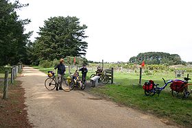
The trail has been constructed along a section of the former Wonthaggi line. The trail starts at the former Anderson Station and finishes shortly after the former Wonthaggi Station. The trail is 16 kilometres (9.9 mi) long and travels from Anderson
heading towards the coast downhill to Kilcunda
, heading along coastal sand dunes into the open farmland surrounding Wonthaggi
.
The original railway line opened in 1910, being used for the transport of coal from Kilcunda and Wonthaggi, and local agricultural produce, as well as for public transport. The line was closed in 1978.
 From Anderson to Kilcunda the trail drops 40 metres (131.2 ft) in height as it winds down through farming country. Here, the gravel path is overgrown and trail users need to negotiate several gates. The rail trail at Kilcunda
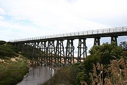
is built on the coastal sand dunes and incorporates a landmark trestle bridge over Bourne Creek. Path users have panoramic scenic views of the Bass Strait
coast and the Wonthaggi Wind Farm that was erected during 2005.
Heading towards Wonthaggi, the trail passes through flat agricultural fields, and is not always well maintained with grass being allowed to overgrow the path. The trail uses a few small bridges to cross the Powlett River and tributaries. The trail near Wonthaggi is packed gravel and features the heritage listed Wonthaggi station, and the historic Central Mine Reserve.
Rail trail
A rail trail is the conversion of a disused railway easement into a multi-use path, typically for walking, cycling and sometimes horse riding. The characteristics of former tracks—flat, long, frequently running through historical areas—are appealing for various development. The term sometimes also...
located in the Bass Coast Shire
Bass Coast Shire
Bass Coast Shire is a Local Government Area in Victoria, Australia. It is located in the south-eastern part of the state, less than 90 minutes from Melbourne, and includes the popular tourist destination, Phillip Island...
of Gippsland
Gippsland
Gippsland is a large rural region in Victoria, Australia. It begins immediately east of the suburbs of Melbourne and stretches to the New South Wales border, lying between the Great Dividing Range to the north and Bass Strait to the south...
, Victoria
Victoria (Australia)
Victoria is the second most populous state in Australia. Geographically the smallest mainland state, Victoria is bordered by New South Wales, South Australia, and Tasmania on Boundary Islet to the north, west and south respectively....
, Australia
Australia
Australia , officially the Commonwealth of Australia, is a country in the Southern Hemisphere comprising the mainland of the Australian continent, the island of Tasmania, and numerous smaller islands in the Indian and Pacific Oceans. It is the world's sixth-largest country by total area...
.
The trail has been constructed along a section of the former Wonthaggi line. The trail starts at the former Anderson Station and finishes shortly after the former Wonthaggi Station. The trail is 16 kilometres (9.9 mi) long and travels from Anderson
Anderson, Victoria
Anderson is a locality in Victoria, Australia. The roundabout which the locality is centralised around has been named the Anderson Roundabout which is all the town is thought of today....
heading towards the coast downhill to Kilcunda
Kilcunda, Victoria
Kilcunda is a seaside town in Victoria. It is located 117 km southeast from Melbourne on the Bass Highway in the Bass Coast Shire of Gippsland, Victoria, Australia. Situated along the rugged coastline between Phillip Island and Wonthaggi, Kilcunda is well known for its popular fishing, surfing...
, heading along coastal sand dunes into the open farmland surrounding Wonthaggi
Wonthaggi, Victoria
Wonthaggi is a town located south east of Melbourne via the South Gippsland and Bass Highways, in the Bass Coast Shire of Gippsland, Victoria, Australia...
.
The original railway line opened in 1910, being used for the transport of coal from Kilcunda and Wonthaggi, and local agricultural produce, as well as for public transport. The line was closed in 1978.
Route description
Kilcunda, Victoria
Kilcunda is a seaside town in Victoria. It is located 117 km southeast from Melbourne on the Bass Highway in the Bass Coast Shire of Gippsland, Victoria, Australia. Situated along the rugged coastline between Phillip Island and Wonthaggi, Kilcunda is well known for its popular fishing, surfing...
is built on the coastal sand dunes and incorporates a landmark trestle bridge over Bourne Creek. Path users have panoramic scenic views of the Bass Strait
Bass Strait
Bass Strait is a sea strait separating Tasmania from the south of the Australian mainland, specifically the state of Victoria.-Extent:The International Hydrographic Organization defines the limits of the Bass Strait as follows:...
coast and the Wonthaggi Wind Farm that was erected during 2005.
Heading towards Wonthaggi, the trail passes through flat agricultural fields, and is not always well maintained with grass being allowed to overgrow the path. The trail uses a few small bridges to cross the Powlett River and tributaries. The trail near Wonthaggi is packed gravel and features the heritage listed Wonthaggi station, and the historic Central Mine Reserve.
Attractions on the trail
- Anderson Station
- Kilcunda Station
- Kilcunda trestle bridgeTrestleA trestle is a rigid frame used as a support, especially referring to a bridge composed of a number of short spans supported by such frames. In the context of trestle bridges, each supporting frame is generally referred to as a bent...
over Bourne Creek - Dalyston Station
- Branch off towards the former Dudley Area mine
- State Mine Station (the trail passes through the location, however it is not officially marked)
- Wonthaggi Station
See also
- Bicycle Trails in Victoria