
Barker, Niagara County, New York
Encyclopedia
Village
A village is a clustered human settlement or community, larger than a hamlet with the population ranging from a few hundred to a few thousand , Though often located in rural areas, the term urban village is also applied to certain urban neighbourhoods, such as the West Village in Manhattan, New...
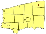
in Niagara County
Niagara County, New York
Niagara County is a county located in the U.S. state of New York. As of the 2010 census, the population was 216,469. The county seat is Lockport. The county name is from the Iroquois word Onguiaahra; meaning the strait or thunder of waters. It is the location of Niagara Falls and Fort Niagara, and...
, New York
New York
New York is a state in the Northeastern region of the United States. It is the nation's third most populous state. New York is bordered by New Jersey and Pennsylvania to the south, and by Connecticut, Massachusetts and Vermont to the east...
, USA
United States
The United States of America is a federal constitutional republic comprising fifty states and a federal district...
. The population was 577 at the 2000 census. The mail ZIP code is 14012. It is part of the Buffalo
Buffalo, New York
Buffalo is the second most populous city in the state of New York, after New York City. Located in Western New York on the eastern shores of Lake Erie and at the head of the Niagara River across from Fort Erie, Ontario, Buffalo is the seat of Erie County and the principal city of the...
–Niagara Falls
Niagara Falls, New York
Niagara Falls is a city in Niagara County, New York, United States. As of the 2010 census, the city had a total population of 50,193, down from the 55,593 recorded in the 2000 census. It is across the Niagara River from Niagara Falls, Ontario , both named after the famed Niagara Falls which they...
Metropolitan Statistical Area
Buffalo-Niagara Falls metropolitan area
The Buffalo-Niagara Falls Metropolitan Statistical Area is a metropolitan area, designated by the United States Census Bureau, encompassing two counties – Erie and Niagara – in Western New York, with a population, as of the 2010 census, of 1,135,509 inhabitants...
.
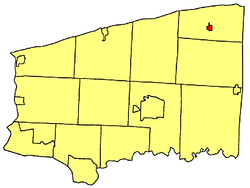
The Village of Barker is within the Town of Somerset
Somerset, New York
Somerset is a town in Niagara County, New York, United States. The population was 2,662 at the 2010 census. The town is believed to be named after Somerset, New Jersey, the source of some early settlers....
and was incorporated in 1908. The main crossroad in the town is the intersection of West Somerset Road and Quaker Road (NY 148
New York State Route 148
New York State Route 148 is a state highway in Niagara County, New York, United States. It runs north–south between a junction with NY 104 in the town of Hartland and NY 18 north of the village of Barker. The entire length of NY 148 is maintained by Niagara County as County...
). There is also an annual Labor Day weekend party known as "The Clam Stock" on Pallister Ave. "The Kerth's Annual Holiday Party" is held annually on the Saturday before Christmas on Palister Ave.
Geography
Barker is located at 43°19′39"N 78°33′13"W (43.327466, -78.553592).According to the United States Census Bureau
United States Census Bureau
The United States Census Bureau is the government agency that is responsible for the United States Census. It also gathers other national demographic and economic data...
, the village has a total area of 0.4 square miles (1 km²), all of it land.
Barker is situated at the junction of West Somerset Road/Coleman Road and Quaker Road (Route 148).
Demographics
As of the censusCensus
A census is the procedure of systematically acquiring and recording information about the members of a given population. It is a regularly occurring and official count of a particular population. The term is used mostly in connection with national population and housing censuses; other common...
of 2000, there were 577 people, 211 households, and 150 families residing in the village. The population density
Population density
Population density is a measurement of population per unit area or unit volume. It is frequently applied to living organisms, and particularly to humans...
was 1,372.3 people per square mile (530.4/km²). There were 234 housing units at an average density of 556.5 per square mile (215.1/km²). The racial makeup of the village was 98.09% White, 0.69% African American, 0.52% Native American, 0.17% from other races
Race (United States Census)
Race and ethnicity in the United States Census, as defined by the Federal Office of Management and Budget and the United States Census Bureau, are self-identification data items in which residents choose the race or races with which they most closely identify, and indicate whether or not they are...
, and 0.52% from two or more races. Hispanic or Latino of any race were 1.56% of the population.
There were 211 households out of which 38.4% had children under the age of 18 living with them, 54.0% were married couples
Marriage
Marriage is a social union or legal contract between people that creates kinship. It is an institution in which interpersonal relationships, usually intimate and sexual, are acknowledged in a variety of ways, depending on the culture or subculture in which it is found...
living together, 10.4% had a female householder with no husband present, and 28.9% were non-families. 24.6% of all households were made up of individuals and 13.7% had someone living alone who was 65 years of age or older. The average household size was 2.73 and the average family size was 3.19.
In the village the population was spread out with 30.3% under the age of 18, 8.1% from 18 to 24, 26.3% from 25 to 44, 21.8% from 45 to 64, and 13.3% who were 65 years of age or older. The median age was 36 years. For every 100 females there were 99.0 males. For every 100 females age 18 and over, there were 93.3 males.
The median income for a household in the village was $37,411, and the median income for a family was $49,464. Males had a median income of $41,875 versus $21,375 for females. The per capita income
Per capita income
Per capita income or income per person is a measure of mean income within an economic aggregate, such as a country or city. It is calculated by taking a measure of all sources of income in the aggregate and dividing it by the total population...
for the village was $16,042. About 8.1% of families and 9.6% of the population were below the poverty line, including 11.0% of those under age 18 and 7.6% of those age 65 or over.