
.gif)
Bamberg (district)
Encyclopedia
Bamberg Land is a district in Bavaria
, Germany
. It surrounds but does not include the town of Bamberg
. The district is bounded by the districts of (from the north and clockwise) Lichtenfels
, Bayreuth
, Forchheim
, Erlangen-Höchstadt
, Neustadt (Aisch)-Bad Windsheim
, Kitzingen
, Schweinfurt
and Haßberge.
.
In 1862 the districts of Bamberg-West and Bamberg-East were established. They were merged in 1929. The present borders were established in 1972, when portions of the adjoining district of Erlangen-Höchstadt
were annexed.
. The western half of the district is occupied by the Steigerwald, a hilly forest region. In the east there is the hill chain of the Frankish Alb. Between these regions the Main River enters the district from the north, turns around just before the town of Bamberg and leaves to the northwest. The smaller Regnitz
River comes from the south and meets the Main behind Bamberg.
Bavaria
Bavaria, formally the Free State of Bavaria is a state of Germany, located in the southeast of Germany. With an area of , it is the largest state by area, forming almost 20% of the total land area of Germany...
, Germany
Germany
Germany , officially the Federal Republic of Germany , is a federal parliamentary republic in Europe. The country consists of 16 states while the capital and largest city is Berlin. Germany covers an area of 357,021 km2 and has a largely temperate seasonal climate...
. It surrounds but does not include the town of Bamberg
Bamberg
Bamberg is a city in Bavaria, Germany. It is located in Upper Franconia on the river Regnitz, close to its confluence with the river Main. Bamberg is one of the few cities in Germany that was not destroyed by World War II bombings because of a nearby Artillery Factory that prevented planes from...
. The district is bounded by the districts of (from the north and clockwise) Lichtenfels
Lichtenfels (district)
Lichtenfels is a district in Bavaria, Germany. It is bounded by the districts of Coburg, Kronach, Kulmbach, Bayreuth and Bamberg.-History:...
, Bayreuth
Bayreuth (district)
Bayreuth is a district in Bavaria, Germany. It surrounds, but does not include the city of Bayreuth. The district is bounded by the districts of Kulmbach, Hof, Wunsiedel, Tirschenreuth, Neustadt/Waldnaab, Amberg-Sulzbach, Nürnberger Land, Forchheim and Bamberg.-History:The district was established...
, Forchheim
Forchheim (district)
Forchheim is a district in Bavaria, Germany. It is bounded by the districts of Bamberg, Bayreuth, Nürnberger Land and Erlangen-Höchstadt.-History:...
, Erlangen-Höchstadt
Erlangen-Höchstadt
Erlangen-Höchstadt is a district in Bavaria, Germany. It is bounded by the districts of Fürth, Neustadt -Bad Windsheim, Bamberg, Forchheim and Nürnberger Land, and by the cities of Nuremberg and Erlangen...
, Neustadt (Aisch)-Bad Windsheim
Neustadt (Aisch)-Bad Windsheim
Neustadt -Bad Windsheim is a district in Bavaria, Germany. It is bounded by the districts of Würzburg, Kitzingen, Bamberg, Erlangen-Höchstadt, Fürth and Ansbach, and by the state of Baden-Württemberg ....
, Kitzingen
Kitzingen (district)
Kitzingen is a district in Bavaria, Germany. It is bounded by the districts of Schweinfurt, Bamberg, Neustadt -Bad Windsheim and Würzburg.-History:...
, Schweinfurt
Schweinfurt (district)
Schweinfurt is a Kreis in the northwestern part of Bavaria, Germany. Neighboring districts are Bad Kissingen, Rhön-Grabfeld, Haßberge, Bamberg, Kitzingen, Würzburg and Main-Spessart. The district-free city Schweinfurt is completely surrounded by the district.-Geography:Primary rivers in the...
and Haßberge.
History
The history of the district is linked with the history of BambergBamberg
Bamberg is a city in Bavaria, Germany. It is located in Upper Franconia on the river Regnitz, close to its confluence with the river Main. Bamberg is one of the few cities in Germany that was not destroyed by World War II bombings because of a nearby Artillery Factory that prevented planes from...
.
In 1862 the districts of Bamberg-West and Bamberg-East were established. They were merged in 1929. The present borders were established in 1972, when portions of the adjoining district of Erlangen-Höchstadt
Erlangen-Höchstadt
Erlangen-Höchstadt is a district in Bavaria, Germany. It is bounded by the districts of Fürth, Neustadt -Bad Windsheim, Bamberg, Forchheim and Nürnberger Land, and by the cities of Nuremberg and Erlangen...
were annexed.
Geography
The district surrounds the town of BambergBamberg
Bamberg is a city in Bavaria, Germany. It is located in Upper Franconia on the river Regnitz, close to its confluence with the river Main. Bamberg is one of the few cities in Germany that was not destroyed by World War II bombings because of a nearby Artillery Factory that prevented planes from...
. The western half of the district is occupied by the Steigerwald, a hilly forest region. In the east there is the hill chain of the Frankish Alb. Between these regions the Main River enters the district from the north, turns around just before the town of Bamberg and leaves to the northwest. The smaller Regnitz
Regnitz
The Regnitz is a river in Bavaria, Germany. It is a left tributary of the Main and is in length.The river is formed by the confluence of the rivers Rednitz and Pegnitz, which meet in the city of Fürth. From there the Regnitz runs northwards through the cities of Erlangen and Forchheim...
River comes from the south and meets the Main behind Bamberg.
Coat of arms
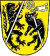 |
The coat of arms displays the heraldic animals of Bamberg and Ebrach, a lion and a boar. |
Sights
 |
Fränkische Straße der Skulpturen | Litzendorf |
 |
Gügel | Scheßlitz |
 |
Giechburg | Scheßlitz |
 |
Kloster Ebrach | Ebrach |
 |
Schloss Greifenstein | Heiligenstadt |
 |
Sängerehrenmal Melkendorf | Litzendorf |
 |
St. Wenzeslaus | Litzendorf |
 |
Schloss Seehof | Memmelsdorf |
 |
Schloss Weißenstein | Pommersfelden |
 |
St.-Veit- und St.-Michaels-Kirche | Heiligenstadt |
Städte
 |
 |
Baunach Baunach Baunach is a town in the Upper Franconian district of Bamberg and the seat of the administrative community of Baunach. Until administrative reform in 1972, Baunach belonged to the Lower Franconian district of Ebern.... |
3.909 inhabitants | 30,9 km² |
 |
> | Hallstadt Hallstadt Hallstadt is a town in the Upper Franconian district of Bamberg on the left bank of the Main, 4 km north of Bamberg.-Geography:Hallstadt borders in the south on the city of Bamberg and in the west on the Main. There are two constituent communities named Hallstadt and Dörfleins... |
8.559 inhabitants | 14,5 km² |
 |
Scheßlitz Scheßlitz Scheßlitz is a town in the Upper Franconian district of Bamberg and lies on the rise to the Franconian Switzerland on the A 70 between Bamberg and Bayreuth, lying 14 km northeast of the former.-Geography:... |
7.160 inhabitants | 94,9 km² | |
 |
 |
Schlüsselfeld Schlüsselfeld Schlüsselfeld is a town on the southwestern edge of the Upper Franconian district of Bamberg-Geography:Schlüsselfeld lies 24 km southwest of Bamberg in the Steigerwald in the valley of the Reiche Ebrach, 299 m above sea level.... |
5.753 inhabitants | 70,2 km² |
Märkte
 |
 |
Burgebrach Burgebrach Burgebrach is a market town in the Upper Franconian district of Bamberg and the seat of the administrative community of Burgebrach.-Geography:... |
6.466 inhabitants | 87,9 km² |
 |
 |
Burgwindheim Burgwindheim Burgwindheim is a community with market rights in the west of the Upper Franconian district of Bamberg and a member of the administrative community of Ebrach.-Geography:... |
1.431 inhabitants | 37,4 km² |
 |
 |
Buttenheim Buttenheim Buttenheim is a market town in the Upper Franconian district of Bamberg and lies in the Regnitz Valley between Bamberg and Nuremberg.Buttenheim is Levi Strauss’s birthplace; the future inventor of blue jeans emigrated from here to the United States in 1847.... |
3.320 inhabitants | 30 km² |
 |
 |
Ebrach Ebrach Ebrach is a community with market rights in the Upper Franconian district of Bamberg and the seat of the administrative community of Ebrach.-Etymology:... |
1.845 inhabitants | 29,6 km² |
 |
 |
Heiligenstadt Heiligenstadt (Upper Franconia) Heiligenstadt in Oberfranken is a community with market rights in the Upper Franconian district of Bamberg.... |
3.642 inhabitants | 76,7 km² |
 |
 |
Hirschaid Hirschaid Hirschaid is a community with market rights in the Upper Franconian district of Bamberg and lies roughly twelve kilometres south of Bamberg on the Regnitz and the Main-Danube Canal.-Location:... |
11.666 inhabitants | 41 km² |
 |
 |
Rattelsdorf Rattelsdorf Rattelsdorf is a community with market rights in the Upper Franconian district of Bamberg .-Geography:Rattelsdorf lies in the Upper Franconia-West region. It consists of 13 smaller population centres which are all found within the same area. Among them, Ebing is the second-biggest... |
4.531 inhabitants | 39,6 km² |
 |
 |
Zapfendorf Zapfendorf Zapfendorf is a community with market rights in the Upper Franconian district of Bamberg in Bavaria, Germany with roughly 5,000 inhabitants.-Geography:... |
5.042 inhabitants | 30,6 km² |
Gemeinden
.png) |
 |
Altendorf Altendorf, Upper Franconia Altendorf is a community in the Upper Franconian district of Bamberg, Bavaria, Germany.- Constituent communities :The namesake centre of Altendorf has 1,544 inhabitants while the outlying amalgamated centre of Seußling has 542 .The community also has two traditional rural land units, known in... |
1.941 inhabitants | 8,6 km² |
 |
 |
Bischberg Bischberg Bischberg is a community in the Upper Franconian district of Bamberg lying at the forks of the rivers Regnitz and Main some 5 km west of Bamberg.The community’s name derives from Bischofsberg... |
6.037 inhabitants | 17,5 km² |
 |
Breitengüßbach Breitengüßbach Breitengüßbach is a community in the Upper Franconian district of Bamberg that has a more than 1,100-year history. It was mentioned as Gusibach and as belonging to the royal court at Hallstadt in an Imperial document issued between 812 and 830.-Name’s meaning:As to the name’s origin, there is no... |
4.614 inhabitants | 16,9 km² | |
 |
 |
Frensdorf Frensdorf Frensdorf is a community in the Upper Franconian district of Bamberg.-Geography:The community lies in Upper Franconia south of Bamberg on the lower reaches of the Rauhe Ebrach.-Constituent communities:... |
4.887 inhabitants | 44 km² |
 |
 |
Gerach Gerach Gerach is a community in the Upper Franconian district of Bamberg and a member of the administrative community of Baunach... |
1.005 inhabitants | 7,8 km² |
 |
 |
Gundelsheim Gundelsheim, Bavaria Gundelsheim is a community in the Upper Franconian district of Bamberg.-Geography:Gundelsheim lies in the Upper Franconia-West region and is found roughly seven kilometres north of Bamberg at the Kreuz Bamberg, a cloverleaf interchange between the Autobahnen A 70 and A 73.The community has one of... |
3.298 inhabitants | 3,8 km² |
 |
 |
Kemmern Kemmern Kemmern is a community in the Upper Franconian district of Bamberg.-Geography:The community of Kemmern lies at an average elevation of 236 to 250 metres some seven kilometres north of Bamberg, right on the Main and at the foot of the Haßberge’s outlying hills. It belongs to the Upper... |
2.554 inhabitants | 8,3 km² |
.jpg) |
 |
Königsfeld | 1.352 inhabitants | 42,7 km² |
 |
 |
Lauter Lauter, Bavaria Lauter is a community in the Upper Franconian district of Bamberg and a member of the administrative community of Baunach.-Geography:... |
1.150 inhabitants | 12,8 km² |
 |
 |
Lisberg Lisberg Lisberg is a community in the Upper Franconian district of Bamberg and a member of the administrative community of Lisberg, lying in the Steigerwald .-Constituent communities:... |
1.753 inhabitants | 8,4 km² |
 |
 |
Litzendorf Litzendorf Litzendorf is a community in the Upper Franconian district of Bamberg. Owing to administrative reform it has been a unified community since 1 May 1978.-Geography:... |
6.045 inhabitants | 25,9 km² |
 |
 |
Memmelsdorf Memmelsdorf Memmelsdorf is a community in the Upper Franconian district of Bamberg bordering in the west directly on the city of Bamberg.- History :As with most places in the Bamberg district, this community’s exact founding time cannot be established. However, looking back through the properties of the royal... |
8.997 inhabitants | 26,2 km² |
 |
 |
Oberhaid Oberhaid Oberhaid is a community in the Upper Franconian district of Bamberg.-Location:The community lies roughly seven kilometres northwest of Bamberg. The highest elevations are the Spitzelberg in the west at 325 m, and the Semberg in the east at 393 m. The location in the Main Valley in the... |
4.668 inhabitants | 27,2 km² |
 |
 |
Pettstadt Pettstadt Pettstadt is a community in the Upper Franconian district of Bamberg with about 1,900 inhabitants.- Geography :The community lies in the Regierungsbezirk of Oberfranken , roughly 8 km south of Bamberg where the Rauhe Ebrach empties into the Regnitz.- Constituent communities :Pettstadt’s main... |
1.917 inhabitants | 9,9 km² |
 |
 |
Pommersfelden Pommersfelden Pommersfelden is a community in the Upper Franconian district of Bamberg.-Constituent communities:The community of Pommersfelden is subdivided into four Gemarkungen with a total of ten settled centres, each given here with its own population figure:*Gemarkung Oberndorf:-Population... |
2.937 inhabitants | 35,7 km² |
 |
 |
Priesendorf Priesendorf Priesendorf is a community in the Upper Franconian district of Bamberg and a member of the administrative community of Lisberg.-Geography:... |
1.534 inhabitants | 8,4 km² |
 |
 |
Reckendorf Reckendorf Reckendorf is a community in the Upper Franconian district of Bamberg, Bavaria, Germany. With roughly 2,000 inhabitants, Reckendorf is a member of the administrative community of Baunach.-Constituent communities:... |
2.043 inhabitants | 13,1 km² |
 |
 |
Schönbrunn im Steigerwald Schönbrunn im Steigerwald Schönbrunn im Steigerwald is a community in the Upper Franconian district of Bamberg and a member of the administrative community of Burgebrach.-Constituent communities:... |
1.935 inhabitants | 24,7 km² |
 |
 |
Stadelhofen Stadelhofen Stadelhofen is a community in the Upper Franconian district of Bamberg and a member of the administrative community of Steinfeld.- Geography :... |
1.261 inhabitants | 41 km² |
 |
 |
Stegaurach Stegaurach Stegaurach is a community in the Upper Franconian district of Bamberg and the seat of the administrative community of Stegaurach.-Geography:... |
6.947 inhabitants | 23,9 km² |
 |
 |
Strullendorf Strullendorf Strullendorf is a community in the Upper Franconian district of Bamberg.-Location:Strullendorf lies in a valley and is partly surrounded by the Hauptsmoorwald , near which lies the Hauptsmoorhalle... |
7.805 inhabitants | 31,7 km² |
 |
 |
Viereth-Trunstadt Viereth-Trunstadt Viereth-Trunstadt is a community in the Upper Franconian district of Bamberg lying on the Main.-Viereth:Viereth lies in the northeast outliers of the Steigerwald and right on the Main’s south bank... |
3.645 inhabitants | 15,8 km² |
 |
 |
Walsdorf Walsdorf Walsdorf is a community in the Upper Franconian district of Bamberg and a member of the administrative community of Stegaurach. It lies in the valley of the Aurach roughly ten kilometres west of Bamberg.-Constituent communities:... |
2.600 inhabitants | 16,2 km² |
 |
 |
Wattendorf Wattendorf Wattendorf is the smallest community in the Upper Franconian district of Bamberg and a member of the administrative community of Steinfeld.-Geography:... |
700 inhabitants | 22,2 km² |
Verwaltungsgemeinschaften
| Verwaltungsgemeinschaft Baunach | Baunach, Gerach, Lauter and Reckendorf |
| Verwaltungsgemeinschaft Burgebrach | Burgebrach and Schönbrunn |
| Verwaltungsgemeinschaft Ebrach | Burgwindheim and Ebrach |
| Verwaltungsgemeinschaft Lisberg | Lisberg and Priesendorf |
| Verwaltungsgemeinschaft Stegaurach | Stegaurach and Walsdorf |
| Verwaltungsgemeinschaft Steinfeld | Königsfeld, Stadelhofen and Wattendorf |
External links
- Official website (German)
- Links to municipalities