
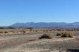
Avawatz Mountains
Encyclopedia
The Avawatz Mountains are located in San Bernardino County
in the Mojave Desert
of San Bernardino County, California
, USA.
; between the Owlshead Mountains
in the southern end of Death Valley National Park
, and the Soda Mountains
near the town of Baker.
Part of the Avawatz Mountain range lies in the National Training Center, which is part of the Fort Irwin Military Reservation
, and is closed to the public.
The Avawatz Mountains reach an elevation of 1876 metres (6,154.9 ft).
San Bernardino County, California
San Bernardino County is a county in the U.S. state of California. As of the 2010 census, the population was 2,035,210, up from 1,709,434 as of the 2000 census...
in the Mojave Desert
Mojave Desert
The Mojave Desert occupies a significant portion of southeastern California and smaller parts of central California, southern Nevada, southwestern Utah and northwestern Arizona, in the United States...
of San Bernardino County, California
San Bernardino County, California
San Bernardino County is a county in the U.S. state of California. As of the 2010 census, the population was 2,035,210, up from 1,709,434 as of the 2000 census...
, USA.
Name
The name "Avawatz" is derived from the Mohave Indian term "Avi-Ahwat", or "red rock".Geography
The range lies to the west of State Route 127California State Route 127
State Route 127 is a California state highway that connects Interstate 15 to Nevada State Route 373, passing through Death Valley National Park....
; between the Owlshead Mountains
Owlshead Mountains
The Owlshead Mountains are located at the southern end of Death Valley National Park near the border of the Fort Irwin Military Reservation in San Bernardino County, California, USA.-Geography:...
in the southern end of Death Valley National Park
Death Valley National Park
Death Valley National Park is a national park in the U.S. states of California and Nevada located east of the Sierra Nevada in the arid Great Basin of the United States. The park protects the northwest corner of the Mojave Desert and contains a diverse desert environment of salt-flats, sand dunes,...
, and the Soda Mountains
Soda Mountains
The Soda Mountains are located in the eastern Mojave Desert in San Bernardino County, California, USA. The range lies to the north of Interstate 15 west of the town of Baker.-Geography:...
near the town of Baker.
Part of the Avawatz Mountain range lies in the National Training Center, which is part of the Fort Irwin Military Reservation
Fort Irwin Military Reservation
Fort Irwin & the National Training Center is a major training area for the United States Military and is a census-designated place located in the Mojave Desert in northern San Bernardino County, California. Fort Irwin sits at an elevation of . The 2010 United States census reported Fort Irwin's...
, and is closed to the public.
The Avawatz Mountains reach an elevation of 1876 metres (6,154.9 ft).