
Audley, New South Wales
Encyclopedia
Southern Sydney
This article refers to an area the same as a combination of St George and SutherlandSouthern Sydney is a general term which is used to describe the southern metropolitan area of Sydney, in the state of New South Wales, Australia....
Sydney
Sydney
Sydney is the most populous city in Australia and the state capital of New South Wales. Sydney is located on Australia's south-east coast of the Tasman Sea. As of June 2010, the greater metropolitan area had an approximate population of 4.6 million people...
, in the state of New South Wales
New South Wales
New South Wales is a state of :Australia, located in the east of the country. It is bordered by Queensland, Victoria and South Australia to the north, south and west respectively. To the east, the state is bordered by the Tasman Sea, which forms part of the Pacific Ocean. New South Wales...
, Australia
Australia
Australia , officially the Commonwealth of Australia, is a country in the Southern Hemisphere comprising the mainland of the Australian continent, the island of Tasmania, and numerous smaller islands in the Indian and Pacific Oceans. It is the world's sixth-largest country by total area...
. It is located in the Royal National Park
Royal National Park
Royal National Park is a national park in New South Wales, Australia, 29 km south of Sydney CBD.Founded by Sir John Robertson, Acting Premier of New South Wales, and formally proclaimed on 26 April 1879, it is the world's second oldest purposed national park, the first usage of the term...
and is part of the Sutherland Shire
Sutherland Shire
The Sutherland Shire is a Local Government Area in the Southern Sydney region of Sydney, Australia. Geographically, it is the area to the south of Botany Bay and the Georges River...
.
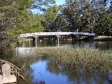
Kangaroo Creek joins the Hacking River
Hacking River
The Hacking River is a stream in the state of New South Wales in Australia. It rises near the Princes Highway west of Stanwell Tops, and flows through the Royal National Park before emptying into Port Hacking...
at Audley. A causeway
Causeway
In modern usage, a causeway is a road or railway elevated, usually across a broad body of water or wetland.- Etymology :When first used, the word appeared in a form such as “causey way” making clear its derivation from the earlier form “causey”. This word seems to have come from the same source by...
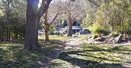
crosses the river here, which is subject to flooding. Audley features extensive picnic areas, boat hire facilities, a bike track and a visitor's centre. Audley is also the location of the administrative headquarters for the Royal National Park.
History
The area was surveyed by Lord George Edward Audley in 1863-64, where he set up camp. He later married Emily, second daughter of Major Sir Thomas Mitchell, the Surveyor-General.Floodgates were constructed in Audley in 1900. Audley developed into a small village of amusements, surrounded by 'pleasure gardens'. It was popular with holiday-makers and honeymooners who could stay at the Allambie House guesthouse. A dance hall was built here in the 1940s, which still stands today.