

Area code 276
Encyclopedia
Telephone
The telephone , colloquially referred to as a phone, is a telecommunications device that transmits and receives sounds, usually the human voice. Telephones are a point-to-point communication system whose most basic function is to allow two people separated by large distances to talk to each other...
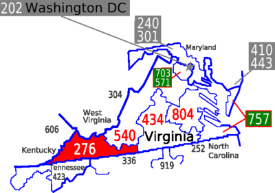
area code 276 was established September 1, 2001 as a split from area code 540
Area code 540
Image:Area code 540.png|right|400px|The area colored red indicates the northern region of Virginia served by area code 540poly 391 103 368 103 343 148 324 152 325 160 317 164 309 174 311 177 302 178 364 181 385 161 Area code 757...
. It covers the southwest corner of the Commonwealth of Virginia
Virginia
The Commonwealth of Virginia , is a U.S. state on the Atlantic Coast of the Southern United States. Virginia is nicknamed the "Old Dominion" and sometimes the "Mother of Presidents" after the eight U.S. presidents born there...
.
Within its service area are the following independent cities
Independent city
An independent city is a city that does not form part of another general-purpose local government entity. These type of cities should not be confused with city-states , which are fully sovereign cities that are not part of any other sovereign state.-Historical precursors:In the Holy Roman Empire,...
:
- BristolBristol, VirginiaBristol is an independent city in Virginia, United States, bounded by Washington County, Virginia, Bristol, Tennessee, and Sullivan County, Tennessee....
- GalaxGalax, VirginiaGalax is an independent city in the southwestern part of the Commonwealth of Virginia. It is bounded to the northeast by Carroll County and to the southwest by Grayson County. The population was 7,042 as of 2010...
- MartinsvilleMartinsville, VirginiaMartinsville is an independent city which is surrounded by Henry County, Virginia, United States. The population was 13,821 in 2010. The Bureau of Economic Analysis combines the city of Martinsville with Henry County for statistical purposes...
- NortonNorton, VirginiaNorton is an independent city within the confines of Wise County in the Commonwealth of Virginia. As of the 2010 Census, the city population was 3,958, making it the smallest city in the state by population...
The following counties are also located in the 276 service area:
- BlandBland County, VirginiaAs of the census of 2000, there were 6,871 people, 2,568 households, and 1,908 families residing in the county. The population density was 19 people per square mile . There were 3,161 housing units at an average density of 9 per square mile...
- BuchananBuchanan County, VirginiaAs of the census of 2000, there were 26,978 people, 10,464 households, and 7,900 families residing in the county. The population density was 54 people per square mile . There were 11,887 housing units at an average density of 24 per square mile...
- CarrollCarroll County, VirginiaAs of the census of 2000, there were 29,245 people, 12,186 households, and 8,786 families residing in the county. The population density was 61 people per square mile . There were 14,680 housing units at an average density of 31 per square mile...
- DickensonDickenson County, VirginiaAs of the census of 2000, there were 16,395 people, 6,732 households, and 4,887 families residing in the county. The population density was 49 people per square mile . There were 7,684 housing units at an average density of 23 per square mile...
- GraysonGrayson County, VirginiaAs of the census of 2000, there were 17,917 people, 7,259 households, and 5,088 families residing in the county. The population density was 40 people per square mile . There were 9,123 housing units at an average density of 21 per square mile...
- HenryHenry County, VirginiaAs of the census of 2000, there were 57,930 people, 23,910 households, and 16,952 families residing in the county. The population density was 152 people per square mile . There were 25,921 housing units at an average density of 68 per square mile...
- LeeLee County, VirginiaAccording to the census 2009 estimates, there were 25001 people, 11,587 households, and 6,852 families residing in the county. The population density was 54 people per square mile . There were 11,587 housing units at an average density of 25 per square mile...
- PatrickPatrick County, VirginiaPatrick County is a county located in the Commonwealth of Virginia. As of 2010, the population was 18,490. Its county seat is Stuart. It is located within both the rolling hills and valleys of the Piedmont Region of Virginia and mountainous Southwest Virginia....
- RussellRussell County, VirginiaAs of the census of 2000, there were 30,308 people, 11,789 households, and 8,818 families residing in the county. The population density was 64 people per square mile . There were 13,191 housing units at an average density of 28 per square mile...
- ScottScott County, VirginiaAs of the census of 2000, there were 23,403 people, 9,795 households, and 7,023 families residing in the county. The population density was 44 people per square mile . There were 11,355 housing units at an average density of 21 per square mile...
- SmythSmyth County, VirginiaAs of the census of 2000, there were 33,081 people, 13,493 households, and 9,607 families residing in the county. The population density was 73 people per square mile . There were 15,111 housing units at an average density of 33 per square mile...
- TazewellTazewell County, VirginiaAs of the census of 2000, there were 44,598 people, 18,277 households and 13,232 families residing in the county. The population density was 86 people per square mile . There were 20,390 housing units at an average density of 39 per square mile...
- WashingtonWashington County, VirginiaAs of the census of 2000, there were 51,103 people, 21,056 households, and 14,949 families residing in the county. The population density was 91 people per square mile . There were 22,985 housing units at an average density of 41 per square mile...
- WiseWise County, VirginiaWise County is a county located in the U.S. state of Virginia. In 1856, the county was formed from land taken from Lee, Scott, and Russell Counties. It was named after Henry A. Wise, who was the Governor of Virginia at the time. As of 2010, the population was 41,452, making it the largest...
- WytheWythe County, VirginiaAs of the census of 2000, there were 27,599 people, 11,511 households, and 8,103 families residing in the county. The population density was 60 people per square mile . There were 12,744 housing units at an average density of 28 per square mile...
See also
- List of Virginia area codes
- List of NANP area codes
- North American Numbering PlanNorth American Numbering PlanThe North American Numbering Plan is an integrated telephone numbering plan administered by Neustar which encompasses 24 countries and territories, including the United States and its territories, Canada, Bermuda, and 16 nations of the Caribbean...