
Arara, Paraíba
Encyclopedia
Arara is a municipality in the state of Paraíba
in northeastern Brazil
. It is located in the mesoregion of Agreste Paraibano and the microregion of Western Curimataú, 142 km from the state capital, João Pessoa
. It is located on the high plain of Borborema at an altitude of 467 m above sea level.
and rapadura
, basic foods available in those areas. The area was known as "Baraúnas das Araras" because of the large number of macaw
s (Portuguese arara) that could be found there as late as 1860, when the priest José Antônio Maria Ibiapina arrived in the area from Ceará
. He had greatly influenced the civilizing of the Curimataú area. He founded the Santa Fé sanitarium near the site of today's city, on land donated by Major Antônio José da Cunha, owner of lime deposits in the area.
Major Antônio José da Cunha also built the first house in the future village of Arara, and contributed much to its development up to 1881, when he died at the age of 94.
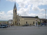
Padre Ibiapina also founded the Mother Church of Arara, under the name of Nossa Senhora da Piedade (Our Lady of Piety), and provided services to the forming community. By 1876, the village had about 80 houses and 500 inhabitants.
In 1937 and 1938, in the administrative division of Brazil, Arara was mentioned as part of the municipality of Serraria
. On 1 December 1961, the town was separated from Serraria and incorporated as a separate municipality. Many people worked toward this goal, including Dr. Marinésio Moreno, Dr. Mário Moreno, and Marísio da Cunha Moreno.
(Brazilian Institute of Geography and Statistics) of 2008, there were 12,698 people residing in the municipality. The population density was 142,9 inh./km².
The last census the IBGE
of 2000, revealed the following numbers: 7,109 Pardo
(Brown) people (61.66%), 4,033 White
people (34.98%), 350 Black
people (3,03%).
Paraíba
Paraíba Paraíba Paraíba (Tupi: pa'ra a'íba: "bad to navigation"; Brazilian Portuguese pronunciation: is a state of Brazil. It is located in the Brazilian Northeast, and is bordered by Rio Grande do Norte to the north, Ceará to the west, Pernambuco to the south and the Atlantic Ocean to the east...
in northeastern Brazil
Brazil
Brazil , officially the Federative Republic of Brazil , is the largest country in South America. It is the world's fifth largest country, both by geographical area and by population with over 192 million people...
. It is located in the mesoregion of Agreste Paraibano and the microregion of Western Curimataú, 142 km from the state capital, João Pessoa
João Pessoa
João Pessoa , is the capital city of the state of Paraíba, was founded in 1585 and sometimes called the city where the sun rises first, is a Brazilian city and the easternmost city in the Americas at 34º47'38"W, 7º9'28"S. Local residents call its easternmost point Ponta do Seixas. It is also...
. It is located on the high plain of Borborema at an altitude of 467 m above sea level.
History
Originally, the area was occupied by the Cariri people. The countryside was covered in Schinopsis brasiliensis trees, whose wood was black, known in the local indigenous language as Baraúna. The trees served as shelter for people traveling to the nearby areas of Brejo and Curimataú to buy flour, cassavaCassava
Cassava , also called yuca or manioc, a woody shrub of the Euphorbiaceae native to South America, is extensively cultivated as an annual crop in tropical and subtropical regions for its edible starchy tuberous root, a major source of carbohydrates...
and rapadura
Rapadura
Rapadura is the Portuguese name for a form of sugarcane juice, used as a sweetener or as a candy, common in Latin American countries such as Brazil, Argentina and Venezuela and the Caribbean. See also panela...
, basic foods available in those areas. The area was known as "Baraúnas das Araras" because of the large number of macaw
Macaw
Macaws are small to large, often colourful New World parrots. Of the many different Psittacidae genera, six are classified as macaws: Ara, Anodorhynchus, Cyanopsitta, Primolius, Orthopsittaca, and Diopsittaca...
s (Portuguese arara) that could be found there as late as 1860, when the priest José Antônio Maria Ibiapina arrived in the area from Ceará
Ceará
Ceará is one of the 27 states of Brazil, located in the northeastern part of the country, on the Atlantic coast. It is currently the 8th largest Brazilian State by population and the 17th by area. It is also one of the main touristic destinations in Brazil. The state capital is the city of...
. He had greatly influenced the civilizing of the Curimataú area. He founded the Santa Fé sanitarium near the site of today's city, on land donated by Major Antônio José da Cunha, owner of lime deposits in the area.
Major Antônio José da Cunha also built the first house in the future village of Arara, and contributed much to its development up to 1881, when he died at the age of 94.
Padre Ibiapina also founded the Mother Church of Arara, under the name of Nossa Senhora da Piedade (Our Lady of Piety), and provided services to the forming community. By 1876, the village had about 80 houses and 500 inhabitants.
In 1937 and 1938, in the administrative division of Brazil, Arara was mentioned as part of the municipality of Serraria
Serraria
Serraria is a town and municipality in the state of Paraíba in the Northeast Region of Brazil.-References:...
. On 1 December 1961, the town was separated from Serraria and incorporated as a separate municipality. Many people worked toward this goal, including Dr. Marinésio Moreno, Dr. Mário Moreno, and Marísio da Cunha Moreno.
Climate
Located on a high plain, the city has a Semi-arid climate, with average annual temperatures in the range of 24°C. The rainy season begins in January or February, and continues to September or October.Demographics
According to the IBGEIBGE
The Brazilian Institute of Geography and Statistics or IBGE , is the agency responsible for statistical, geographic, cartographic, geodetic and environmental information in Brazil...
(Brazilian Institute of Geography and Statistics) of 2008, there were 12,698 people residing in the municipality. The population density was 142,9 inh./km².
The last census the IBGE
IBGE
The Brazilian Institute of Geography and Statistics or IBGE , is the agency responsible for statistical, geographic, cartographic, geodetic and environmental information in Brazil...
of 2000, revealed the following numbers: 7,109 Pardo
Pardo
In Brazil, Pardo is a race/colour category used by the Brazilian Institute of Geography and Statistics in Brazilian censuses. It is a Portuguese word that encompasses various shades of brown, but is usually translated as "grayish-brown"...
(Brown) people (61.66%), 4,033 White
White Brazilian
White Brazilians make up 48.4% of Brazil's population, or around 92 million people, according to the IBGE's 2008 PNAD . Whites are present in the entire territory of Brazil, although the main concentrations are found in the South and Southeastern parts of the country...
people (34.98%), 350 Black
Afro-Brazilian
In Brazil, the term "preto" is one of the five categories used by the Brazilian Census, along with "branco" , "pardo" , "amarelo" and "indígena"...
people (3,03%).
List of Mayors
| Name of Mayor | Period |
| Marísio da Cunha Moreno | 1962 - 1966 |
| Joaquim Pereira de Morais | 1966 - 1970 |
| Reginaldo Azevedo do Nascimento | 1970 - 1973 |
| Joaquim Pereira de Morais | 1973 - 1977 |
| José Medeiros dos Santos | 1977 - 1983 |
| Moacir Jerônimo da Costa | 1983 - 1988 |
| José Medeiros dos Santos | 1989 - 1992 |
| José Ibiapina Soares do Nascimento | 1993 - 1996 |
| José Ernesto dos Santos Sobrinho | 1997 - 2000 |
| José Ibiapina Soares do Nascimento | 2001 - 2004 |
| José Ernesto dos Santos Sobrinho | 2005 - 2008 |