
Ann W. Richards Congress Avenue Bridge
Encyclopedia
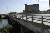
The Ann W. Richards Congress Avenue Bridge (formerly known simply as the Congress Avenue Bridge) crosses over Lady Bird Lake in Austin
, Texas
. Before the construction of Longhorn Dam
was completed in 1960, the bridge crossed the Colorado River
from which Lady Bird Lake is impounded. The bridge was known as the Congress Avenue Bridge from the construction of the first span across the Colorado River at that location in the late 19th century until November 16, 2006, when the Austin City Council renamed the current bridge in honor of the late Ann W. Richards, the 45th Governor of Texas
and Austin resident. The bridge is a concrete arch bridge
, with three southbound and three northbound vehicle lanes and sidewalks on both sides of the bridge.
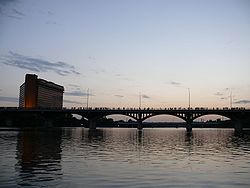
The bridge is currently home to the world's largest urban bat colony.
The first bridge across the Colorado River in this location was constructed in 1869 or 1871. The original structure was a pontoon
toll
bridge. In 1875, a new wooden toll bridge was constructed across the river. The bridge’s construction was finished at a cost of $80,000.00; an additional $20,000.00 was used to macadamize dykes across lowlands and a culvert
over Bouldin Branch. On one occasion, a herd of cattle caused a span fifty feet above the water to give way. Only a few cattle were rescued.
On January 22, 1884, a modern iron bridge funded by private interests was opened at a cost of $74,000.00. There were sufficient spans to allow for the highest stage of over-flow when the river flood
ed. The bridge was designed and built by engineer C.Q. Horton. The bridge was purchased by the Travis County Road and Bridge Co. and the City of Austin on June 18, 1886. By 1891, the Travis County Road and Bridge Co. refused to care for the bridge, and Travis County Commissioners negotiated an agreement whereby the City of Austin assumed complete control of the bridge's operation. The city was forced to repair the bridge in 1892 and again in 1897, when the city paid half the cost for re-flooring, a task that took until 1901 to complete. The bridge was repainted in 1902.
By 1908, traffic across the bridge had increased to the point where a new bridge was needed. Plans for a new concrete arch bridge were drawn as follows: "New Bridge: 910 FT Long iron bridge; 6 spans { 5-150FT Long, 1-160, 27 FT. Tall, 18 FT. Roadway, Bridge Piers are 45 FT. above ground. Will be built by King Bridge Co. of Cleveland, Ohio. Strength: 2,000 LBS per FT. – But was built four times as strong". The new bridge was opened on April 4, 1910, at a final cost of $208,950.10. Sections of the old iron bridge were later used in 1915 and 1922 to rebuild the bridge at nearby Moore's Crossing
.
The bridge was rehabilitated in 1980.
On November 16, 2006, the Austin City Council renamed the bridge the Ann W. Richards Congress Avenue Bridge at its weekly meeting. The late Governor of Texas was also a part-time Austin resident and former Travis County
Commissioner.
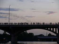
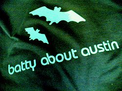 Ann W. Richards Congress Avenue Bridge is home to the world's largest urban bat colony, which is composed of Mexican Free-tailed Bat
s. The bats reside beneath the road deck in gaps between the concrete component structures. They are migratory, spending their summers in Austin and the winters in Mexico
. According to Bat Conservation International
, between 750,000 and 1.5 million bats reside underneath the bridge each summer. Since Austin's human population is about 750,000, there are more bats than people in Austin during the summer.
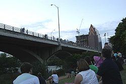
The nightly emergence of the bats from underneath the bridge at dusk
, and their flight across Lady Bird Lake primarily to the east, to feed themselves, attracts as many as 100,000 tourists annually. Tourists can see the bats from the bridge, from the sides of the river and even from special boats.
A study made in 1999 by Dr Gail R. Ryser and Roxana Popovici concludes that the economic impact of the bats to Austin city is $7.9 million each year. Today, businesses are using the bats as a symbol for Austin.
A project, called "Bats and Bridges", has been put in place by the Texas Department of Transportation, in cooperation with BCI, to study the best way to make bridges habitable for bats.
Austin, Texas
Austin is the capital city of the U.S. state of :Texas and the seat of Travis County. Located in Central Texas on the eastern edge of the American Southwest, it is the fourth-largest city in Texas and the 14th most populous city in the United States. It was the third-fastest-growing large city in...
, Texas
Texas
Texas is the second largest U.S. state by both area and population, and the largest state by area in the contiguous United States.The name, based on the Caddo word "Tejas" meaning "friends" or "allies", was applied by the Spanish to the Caddo themselves and to the region of their settlement in...
. Before the construction of Longhorn Dam
Longhorn Dam
Longhorn Dam is a dam located at 30.2504, -97.7135 on the Colorado River within the city limits of Austin, Texas, USA. Longhorn Dam was built by the city of Austin and finished in 1960 as the last in a chain of Colorado River dams in central Texas started during the Great Depression...
was completed in 1960, the bridge crossed the Colorado River
Colorado River (Texas)
The Colorado River is a river that runs through the U.S. state of Texas; it should not be confused with the much longer Colorado River which flows from Colorado into the Gulf of California....
from which Lady Bird Lake is impounded. The bridge was known as the Congress Avenue Bridge from the construction of the first span across the Colorado River at that location in the late 19th century until November 16, 2006, when the Austin City Council renamed the current bridge in honor of the late Ann W. Richards, the 45th Governor of Texas
Governor of Texas
The governor of Texas is the head of the executive branch of Texas's government and the commander-in-chief of the state's military forces. The governor has the power to either approve or veto bills passed by the Texas Legislature, and to convene the legislature...
and Austin resident. The bridge is a concrete arch bridge
Arch bridge
An arch bridge is a bridge with abutments at each end shaped as a curved arch. Arch bridges work by transferring the weight of the bridge and its loads partially into a horizontal thrust restrained by the abutments at either side...
, with three southbound and three northbound vehicle lanes and sidewalks on both sides of the bridge.
The bridge is currently home to the world's largest urban bat colony.
History
The first bridge across the Colorado River in this location was constructed in 1869 or 1871. The original structure was a pontoon
Pontoon
Pontoon may refer to:* Float , an air-filled structure providing buoyancy* Pontoon , the Australian/Malaysian casino game* Pontoon , a chiefly British version of the card game blackjack...
toll
Toll bridge
A toll bridge is a bridge over which traffic may pass upon payment of a toll, or fee.- History :The practice of collecting tolls on bridges probably harks back to the days of ferry crossings where people paid a fee to be ferried across stretches of water. As boats became impractical to carry large...
bridge. In 1875, a new wooden toll bridge was constructed across the river. The bridge’s construction was finished at a cost of $80,000.00; an additional $20,000.00 was used to macadamize dykes across lowlands and a culvert
Culvert
A culvert is a device used to channel water. It may be used to allow water to pass underneath a road, railway, or embankment. Culverts can be made of many different materials; steel, polyvinyl chloride and concrete are the most common...
over Bouldin Branch. On one occasion, a herd of cattle caused a span fifty feet above the water to give way. Only a few cattle were rescued.
On January 22, 1884, a modern iron bridge funded by private interests was opened at a cost of $74,000.00. There were sufficient spans to allow for the highest stage of over-flow when the river flood
Flood
A flood is an overflow of an expanse of water that submerges land. The EU Floods directive defines a flood as a temporary covering by water of land not normally covered by water...
ed. The bridge was designed and built by engineer C.Q. Horton. The bridge was purchased by the Travis County Road and Bridge Co. and the City of Austin on June 18, 1886. By 1891, the Travis County Road and Bridge Co. refused to care for the bridge, and Travis County Commissioners negotiated an agreement whereby the City of Austin assumed complete control of the bridge's operation. The city was forced to repair the bridge in 1892 and again in 1897, when the city paid half the cost for re-flooring, a task that took until 1901 to complete. The bridge was repainted in 1902.
By 1908, traffic across the bridge had increased to the point where a new bridge was needed. Plans for a new concrete arch bridge were drawn as follows: "New Bridge: 910 FT Long iron bridge; 6 spans { 5-150FT Long, 1-160, 27 FT. Tall, 18 FT. Roadway, Bridge Piers are 45 FT. above ground. Will be built by King Bridge Co. of Cleveland, Ohio. Strength: 2,000 LBS per FT. – But was built four times as strong". The new bridge was opened on April 4, 1910, at a final cost of $208,950.10. Sections of the old iron bridge were later used in 1915 and 1922 to rebuild the bridge at nearby Moore's Crossing
Moore's Crossing
Moore's Crossing Historic District is a community located in rural Travis County nine miles southeast of Austin, Texas near the Austin-Bergstrom International Airport....
.
The bridge was rehabilitated in 1980.
On November 16, 2006, the Austin City Council renamed the bridge the Ann W. Richards Congress Avenue Bridge at its weekly meeting. The late Governor of Texas was also a part-time Austin resident and former Travis County
Travis County, Texas
As of 2009, the U.S. census estimates there were 1,026,158 people, 320,766 households, and 183,798 families residing in the county. The population density was 821 people per square mile . There were 335,881 housing units at an average density of 340 per square mile...
Commissioner.
Bats
Mexican Free-tailed Bat
The Mexican free-tailed bat , also known as the Brazilian free-tailed bat, is a medium-sized bat that is native to the Americas and is widely regarded as one of the most abundant mammals in North America...
s. The bats reside beneath the road deck in gaps between the concrete component structures. They are migratory, spending their summers in Austin and the winters in Mexico
Mexico
The United Mexican States , commonly known as Mexico , is a federal constitutional republic in North America. It is bordered on the north by the United States; on the south and west by the Pacific Ocean; on the southeast by Guatemala, Belize, and the Caribbean Sea; and on the east by the Gulf of...
. According to Bat Conservation International
Bat Conservation International
Bat Conservation International is an international non-governmental organization working to conserve the world’s bats and their habitats through conservation, education and research efforts....
, between 750,000 and 1.5 million bats reside underneath the bridge each summer. Since Austin's human population is about 750,000, there are more bats than people in Austin during the summer.
The nightly emergence of the bats from underneath the bridge at dusk
Dusk
Dusk is the beginning of darkness in the evening, and occurs after twilight, when the sky generally remains bright and blue. Civil dusk is when the earth has rotated enough that the center of the sun is at 6° below the local horizon...
, and their flight across Lady Bird Lake primarily to the east, to feed themselves, attracts as many as 100,000 tourists annually. Tourists can see the bats from the bridge, from the sides of the river and even from special boats.
A study made in 1999 by Dr Gail R. Ryser and Roxana Popovici concludes that the economic impact of the bats to Austin city is $7.9 million each year. Today, businesses are using the bats as a symbol for Austin.
A project, called "Bats and Bridges", has been put in place by the Texas Department of Transportation, in cooperation with BCI, to study the best way to make bridges habitable for bats.
See also
- Congress AvenueCongress AvenueCongress Avenue is a major thoroughfare in Austin, Texas. The street is a six-lane, tree lined avenue that cuts through the middle of the city from far south Austin and goes over Lady Bird Lake leading to the Texas State Capitol in the heart of downtown....
- South CongressSouth CongressSouth Congress is a neighborhood located on South Congress Avenue in Austin, Texas, United States. It is also a nationally-known shopping and cultural district famous for its many eclectic small retailers, restaurants, music and art venues and, more recently, food trucks.South Congress begins at...
- List of crossings of the Colorado River
External links
- ARKive - images and movies of the Brazilian free-tailed bat (Tadarida brasiliensis)
- Bat Conservation International website
- Mexican Bats Find Cross-Border Benefactors (Washington Post)
- Bat Conservation International webpage about Mexican free-tailed bats
- BatCon Webpage about Congress Avenue Bridge and its bats.