
Angora Lakes
Encyclopedia
The Angora Lakes are two small freshwater
lake
s in the Sierra Nevada and Lake Tahoe Watershed ~1200 ft (365.8 m) in elevation above Fallen Leaf Lake and Lake Tahoe
. It is the location of the Angora Lakes Resort, a small summer outdoor recreation location. The lakes were named for a herd of Angora goat
s that used to graze in the area.
To reach Angora Lakes from Hwy 89, take the Fallen Leaf Lake Rd. turnoff for approximately 2 miles (3.2 km). (Alternate route: Lake Tahoe Blvd. to Tahoe Mountain Rd.) Turn left and climb to the top of the one-lane road and look for the dirt road and a sign reading "1214". From there an at times steep and at times paved road leads to fantastic vistas and ending in the Angora Lakes parking lot. There is a short 1 miles (1.6 km) uphill hike to Angora Lake.
A cliff face at the upper lake can serve as a jumping platform. The highest ledge that is typically used is approximately sixty feet above the water. During the summer tourist season, jumps are frequent.
and the smaller Stateline, Nevada
; smaller centers on the northern shoreline include Tahoe City
and Kings Beach
.
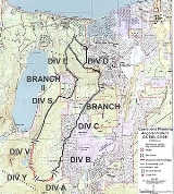
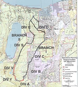 The so-called "Angora Fire
" started around 1:00 pm on Sunday, June 24, 2007 at the southern end of remote heavily-forested land below Angora Ridge Road and extending from Meyers and Fallen Leaf Lake on the south and west, to Camp Richardson near Lake Tahoe's southern shore. Strong winds caused the fire to quickly spread uncontrolled through steep terrain. Most of the devastation to homes was near N. Upper Truckee Rd. where the fire destroyed 254 homes, damaged 26 homes, numerous other structures valued at $141 million and prompted 3,000 evacuations, making it among the half dozen or so most destructive fires in U.S. history. No commercial structures were involved. At a cost of $15 million, 2,100 firefighters, 145 engines and 9 air tankers battled the blaze which consumed 3,100 acres (12.5 square kilometers) and filled the entire Tahoe basin with dense smoke for several days. High winds initially spread the fire and caused most of the property losses, but much calmer conditions on the ensuing three days allowed firefighters to contain it 70% with firebreak lines around it.
No thunderstorms were in the area at the time and it is assumed that the fire was human-caused.
The ash from the fire that falls in Lake Tahoe is considered to be a problem for the clarity of Lake Tahoe and Governor Schwarzenegger of California pledged to spend the necessary funds to restore the land values adequately to prevent erosion from depositing the ash on the ground into the lake and further damaging it.
Fresh Water
Fresh Water is the debut album by Australian rock and blues singer Alison McCallum, released in 1972. Rare for an Australian artist at the time, it came in a gatefold sleeve...
lake
Lake
A lake is a body of relatively still fresh or salt water of considerable size, localized in a basin, that is surrounded by land. Lakes are inland and not part of the ocean and therefore are distinct from lagoons, and are larger and deeper than ponds. Lakes can be contrasted with rivers or streams,...
s in the Sierra Nevada and Lake Tahoe Watershed ~1200 ft (365.8 m) in elevation above Fallen Leaf Lake and Lake Tahoe
Lake Tahoe
Lake Tahoe is a large freshwater lake in the Sierra Nevada of the United States. At a surface elevation of , it is located along the border between California and Nevada, west of Carson City. Lake Tahoe is the largest alpine lake in North America. Its depth is , making it the USA's second-deepest...
. It is the location of the Angora Lakes Resort, a small summer outdoor recreation location. The lakes were named for a herd of Angora goat
Angora goat
The Angora goat is a breed of domestic goat that originated in Ankara , Turkey and its surrounding region in central Anatolia...
s that used to graze in the area.
To reach Angora Lakes from Hwy 89, take the Fallen Leaf Lake Rd. turnoff for approximately 2 miles (3.2 km). (Alternate route: Lake Tahoe Blvd. to Tahoe Mountain Rd.) Turn left and climb to the top of the one-lane road and look for the dirt road and a sign reading "1214". From there an at times steep and at times paved road leads to fantastic vistas and ending in the Angora Lakes parking lot. There is a short 1 miles (1.6 km) uphill hike to Angora Lake.
Tourist activities
The road to the lower parking lot is open from approximately May 1 to October 1, during which time the resort may be accessed on foot. At the resort at the upper lake, a small snack bar serves sandwiches, "world famous" lemonade, and ice cream. Rowboats and kayaks can be rented.A cliff face at the upper lake can serve as a jumping platform. The highest ledge that is typically used is approximately sixty feet above the water. During the summer tourist season, jumps are frequent.
Water sports
During the summer, the lake is popular for water sports, cliff jumping, and beach activities. The two cities most identified with the Lake Tahoe tourist area are South Lake Tahoe, CaliforniaSouth Lake Tahoe, California
South Lake Tahoe is the most populous city in El Dorado County, California, in the Sierra Nevada Mountains. The population was 21,403 at the 2010 census, down from 23,609 at the 2000 census...
and the smaller Stateline, Nevada
Stateline, Nevada
-Demographics:As of the census of 2000, there were 1,215 people, 510 households, and 245 families residing in the CDP. The population density was 1,803.3 people per square mile . There were 562 housing units at an average density of 834.1 per square mile...
; smaller centers on the northern shoreline include Tahoe City
Tahoe City, California
Tahoe City is an unincorporated community in Placer County, California. Tahoe City is located on Lake Tahoe, southeast of Donner Pass. It lies at an elevation of 6250 feet ....
and Kings Beach
Kings Beach, California
Kings Beach is a census-designated place in Placer County, California, United States on the north shore of Lake Tahoe. It is part of the Sacramento–Arden-Arcade–Roseville Metropolitan Statistical Area. The population was 3,796 at the 2010 census, down from 4,037 at the 2000 census.The...
.
Angora Fire of 2007
Angora Fire
The Angora Fire was a wind driven fire that started near North Upper Truckee Road subdivision near Angora Lakes, Fallen Leaf Lake, Echo Lake and South Lake Tahoe, California around 2:15 PM on Sunday, June 24, 2007 as a result of an illegal campfire. As of July 2, 2007, the fire was 100%...
" started around 1:00 pm on Sunday, June 24, 2007 at the southern end of remote heavily-forested land below Angora Ridge Road and extending from Meyers and Fallen Leaf Lake on the south and west, to Camp Richardson near Lake Tahoe's southern shore. Strong winds caused the fire to quickly spread uncontrolled through steep terrain. Most of the devastation to homes was near N. Upper Truckee Rd. where the fire destroyed 254 homes, damaged 26 homes, numerous other structures valued at $141 million and prompted 3,000 evacuations, making it among the half dozen or so most destructive fires in U.S. history. No commercial structures were involved. At a cost of $15 million, 2,100 firefighters, 145 engines and 9 air tankers battled the blaze which consumed 3,100 acres (12.5 square kilometers) and filled the entire Tahoe basin with dense smoke for several days. High winds initially spread the fire and caused most of the property losses, but much calmer conditions on the ensuing three days allowed firefighters to contain it 70% with firebreak lines around it.
No thunderstorms were in the area at the time and it is assumed that the fire was human-caused.
The ash from the fire that falls in Lake Tahoe is considered to be a problem for the clarity of Lake Tahoe and Governor Schwarzenegger of California pledged to spend the necessary funds to restore the land values adequately to prevent erosion from depositing the ash on the ground into the lake and further damaging it.
Nearby peaks and mountains
- Echo PeakEcho PeakEcho Peak is a mountain in the Sierra Nevada range to the west of Lake Tahoe on the border of the Desolation Wilderness in El Dorado County, California....
8,895 ft (2,711.2 m) - Angora PeakAngora PeakAngora Peak is a summit in the Sierra Nevada south of Lake Tahoe in El Dorado County, California. The area is administered by the Eldorado National Forest and is in the Desolation Wilderness....
8,588 ft (2,617.6 m) - Mount TallacMount TallacMount Tallac is a mountain peak southwest of Lake Tahoe, in El Dorado County, California. The peak lies within the Desolation Wilderness on the Eldorado National Forest. It is quite visible from State Route 89...
9,735 ft (2,967 m) - Ralston Peak 9,235 ft (2,814.8 m)
- Pyramid PeakPyramid Peak (California)Pyramid Peak is a mountain in the California's Sierra Nevada within the Crystal Range and to the west of Lake Tahoe. It is the highest point in the Desolation Wilderness. With an elevation gain of almost , the Rocky Canyon route is the mountain's most popular approach although it is very arduous....
9,985 ft (3,043.4 m)