
Angels Landing
Encyclopedia
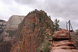
Angels Landing, known earlier as the Temple of Aeolus, is a rock formation
measuring around 1208 feet (368.2 m) tall in Zion National Park
in southern Utah
. A trail, cut into solid rock in 1926, leads to the top of Angels Landing and provides a spectacular view of Zion Canyon
.
for some time, slowly gaining elevation in sandy terrain. As the trail gets steeper and leaves behind the river, it becomes paved. After a series of steep switchbacks
, the trail goes through the area between Angels Landing and the Zion Canyon that is a gradual ascent. Walter's Wiggles, a series of 21 steep switchbacks, are the last hurdle before Scout Lookout. Scout Lookout is generally the turnaround point for those who are unwilling to make the final summit push to the top of Angels Landing. The last half-mile of the trail is strenuous and littered with sharp drop offs and narrow paths. Chains to grip are provided for portions of the last half-mile to the top at 5785 feet (1,763.3 m).
According to the National Park Service
, "The route to Angels Landing involves travel along a steep, narrow ridge with support chains anchored intermittently along the route. Footing can be slippery even when the rock is dry. Unevenly surfaced steps are cut into the rock with major cliff dropoffs adjacent. Keep off when it is wet, icy or thunderstorms are in the area. Plan to be off before dark. Younger children should skip this trail; older children must be closely supervised." The National Park Service website officially recognizes five fatalities along Angels Landing , however, other deaths have been reported.
Formation of rocks
The three main ways rocks are formed:* Sedimentary rocks are formed through the gradual accumulation of sediment: for example, sand on a beach or mud on a river bed. As the sediment is buried it is compacted as more and more material is deposited on top. Eventually the sediment will become so dense...
measuring around 1208 feet (368.2 m) tall in Zion National Park
Zion National Park
Zion National Park is located in the Southwestern United States, near Springdale, Utah. A prominent feature of the park is Zion Canyon, which is 15 miles long and up to half a mile deep, cut through the reddish and tan-colored Navajo Sandstone by the North Fork of the Virgin River...
in southern Utah
Utah
Utah is a state in the Western United States. It was the 45th state to join the Union, on January 4, 1896. Approximately 80% of Utah's 2,763,885 people live along the Wasatch Front, centering on Salt Lake City. This leaves vast expanses of the state nearly uninhabited, making the population the...
. A trail, cut into solid rock in 1926, leads to the top of Angels Landing and provides a spectacular view of Zion Canyon
Geology of the Zion and Kolob canyons area
The geology of the Zion and Kolob canyons area includes nine known exposed formations, all visible in Zion National Park in the U.S. state of Utah. Together, these formations represent about 150 million years of mostly Mesozoic-aged sedimentation in that part of North America...
.
Trail
The trail is 2.4 miles (3,862.4 m) long. It begins at the Grotto drop off point on the park's shuttle system. It roughly follows the path of the Virgin RiverVirgin River
The Virgin River is a tributary of the Colorado River in the U.S. states of Utah, Nevada, and Arizona. The river is about long. It was designated Utah's first wild and scenic river in 2009, during the centennial celebration of Zion National Park.-Course:...
for some time, slowly gaining elevation in sandy terrain. As the trail gets steeper and leaves behind the river, it becomes paved. After a series of steep switchbacks
Hairpin turn
A hairpin turn , named for its resemblance to a hairpin/bobby pin, is a bend in a road with a very acute inner angle, making it necessary for an oncoming vehicle to turn almost 180° to continue on the road. Such turns in ramps and trails may be called switchbacks in American English, by analogy...
, the trail goes through the area between Angels Landing and the Zion Canyon that is a gradual ascent. Walter's Wiggles, a series of 21 steep switchbacks, are the last hurdle before Scout Lookout. Scout Lookout is generally the turnaround point for those who are unwilling to make the final summit push to the top of Angels Landing. The last half-mile of the trail is strenuous and littered with sharp drop offs and narrow paths. Chains to grip are provided for portions of the last half-mile to the top at 5785 feet (1,763.3 m).
According to the National Park Service
National Park Service
The National Park Service is the U.S. federal agency that manages all national parks, many national monuments, and other conservation and historical properties with various title designations...
, "The route to Angels Landing involves travel along a steep, narrow ridge with support chains anchored intermittently along the route. Footing can be slippery even when the rock is dry. Unevenly surfaced steps are cut into the rock with major cliff dropoffs adjacent. Keep off when it is wet, icy or thunderstorms are in the area. Plan to be off before dark. Younger children should skip this trail; older children must be closely supervised." The National Park Service website officially recognizes five fatalities along Angels Landing , however, other deaths have been reported.
External links
- Angels Landing hike and trip report. February 2010.
- Angel's Landing trip report