
Geology of the Zion and Kolob canyons area
Encyclopedia
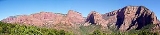
Zion National Park
Zion National Park is located in the Southwestern United States, near Springdale, Utah. A prominent feature of the park is Zion Canyon, which is 15 miles long and up to half a mile deep, cut through the reddish and tan-colored Navajo Sandstone by the North Fork of the Virgin River...
in the U.S. state of Utah
Utah
Utah is a state in the Western United States. It was the 45th state to join the Union, on January 4, 1896. Approximately 80% of Utah's 2,763,885 people live along the Wasatch Front, centering on Salt Lake City. This leaves vast expanses of the state nearly uninhabited, making the population the...
. Together, these formations represent about 150 million years of mostly Mesozoic
Mesozoic
The Mesozoic era is an interval of geological time from about 250 million years ago to about 65 million years ago. It is often referred to as the age of reptiles because reptiles, namely dinosaurs, were the dominant terrestrial and marine vertebrates of the time...
-aged sedimentation
Sedimentation
Sedimentation is the tendency for particles in suspension to settle out of the fluid in which they are entrained, and come to rest against a barrier. This is due to their motion through the fluid in response to the forces acting on them: these forces can be due to gravity, centrifugal acceleration...
in that part of North America. Part of a super-sequence of rock units called the Grand Staircase
Grand Staircase
For the similarly named structure on the RMS Titanic, see Grand Staircase of the TitanicFor the stairs in the White House see Grand Staircase ...
, the formations exposed in the Zion and Kolob area were deposited in several different environments that range from the warm shallow seas of the Kaibab and Moenkopi formations, stream
Stream
A stream is a body of water with a current, confined within a bed and stream banks. Depending on its locale or certain characteristics, a stream may be referred to as a branch, brook, beck, burn, creek, "crick", gill , kill, lick, rill, river, syke, bayou, rivulet, streamage, wash, run or...
s and lake
Lake
A lake is a body of relatively still fresh or salt water of considerable size, localized in a basin, that is surrounded by land. Lakes are inland and not part of the ocean and therefore are distinct from lagoons, and are larger and deeper than ponds. Lakes can be contrasted with rivers or streams,...
s of the Chinle, Moenave, and Kayenta formations to the large desert
Desert
A desert is a landscape or region that receives an extremely low amount of precipitation, less than enough to support growth of most plants. Most deserts have an average annual precipitation of less than...
s of the Navajo and Temple Cap formations and dry near shore environments of the Carmel Formation.
Subsequent uplift of the Colorado Plateau
Colorado Plateau
The Colorado Plateau, also called the Colorado Plateau Province, is a physiographic region of the Intermontane Plateaus, roughly centered on the Four Corners region of the southwestern United States. The province covers an area of 337,000 km2 within western Colorado, northwestern New Mexico,...
slowly raised these formations much higher than where they were deposited. This steepened the stream gradient
Stream gradient
Stream gradient is the grade measured by the ratio of drop in a stream per unit distance, usually expressed as feet per mile or metres per kilometre.-Hydrology and geology:A high gradient indicates a steep slope and rapid flow of water Stream gradient is the grade (slope) measured by the ratio of...
of the ancestral rivers and other streams on the plateau
Plateau
In geology and earth science, a plateau , also called a high plain or tableland, is an area of highland, usually consisting of relatively flat terrain. A highly eroded plateau is called a dissected plateau...
. The faster-moving streams took advantage of uplift-created joints in the rocks to remove all Cenozoic
Cenozoic
The Cenozoic era is the current and most recent of the three Phanerozoic geological eras and covers the period from 65.5 mya to the present. The era began in the wake of the Cretaceous–Tertiary extinction event at the end of the Cretaceous that saw the demise of the last non-avian dinosaurs and...
-aged formations and cut gorges into the plateaus. Zion Canyon was cut by the North Fork of the Virgin River
Virgin River
The Virgin River is a tributary of the Colorado River in the U.S. states of Utah, Nevada, and Arizona. The river is about long. It was designated Utah's first wild and scenic river in 2009, during the centennial celebration of Zion National Park.-Course:...
in this way. Lava
Lava
Lava refers both to molten rock expelled by a volcano during an eruption and the resulting rock after solidification and cooling. This molten rock is formed in the interior of some planets, including Earth, and some of their satellites. When first erupted from a volcanic vent, lava is a liquid at...
flows and cinder cone
Cinder cone
According to the , Cinder Cone is the proper name of 1 cinder cone in Canada and 7 cinder cones in the United States:In Canada: Cinder Cone In the United States:...
s covered parts of the area during the later part of this process.
Zion National Park includes an elevated plateau that consists of sedimentary
Sedimentary rock
Sedimentary rock are types of rock that are formed by the deposition of material at the Earth's surface and within bodies of water. Sedimentation is the collective name for processes that cause mineral and/or organic particles to settle and accumulate or minerals to precipitate from a solution....
formations that dip very gently to the east. This means that the oldest strata
Stratum
In geology and related fields, a stratum is a layer of sedimentary rock or soil with internally consistent characteristics that distinguish it from other layers...
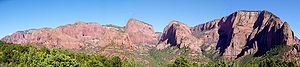
are exposed along the Virgin River in the Zion Canyon part of the park, and the youngest are exposed in the Kolob Canyons
Kolob Canyons
Kolob Canyons is the northwest section of Zion National Park of Utah, United States. The Kolob Canyons are part of the Colorado Plateau region of the park and are noted for their colorful beauty and diverse landscape. This part of Zion National Park is accessed by a park road about 20 miles south...
section. The plateau is bounded on the east by the Sevier Fault Zone, and on the west by the Hurricane Fault Zone. Weathering
Weathering
Weathering is the breaking down of rocks, soils and minerals as well as artificial materials through contact with the Earth's atmosphere, biota and waters...
and erosion along north-trending faults and fractures influence the formation of landscape features, such as canyons, in this region.
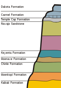
Grand Staircase and basement rocks
The Grand Staircase is an immense sequence of sedimentary rockSedimentary rock
Sedimentary rock are types of rock that are formed by the deposition of material at the Earth's surface and within bodies of water. Sedimentation is the collective name for processes that cause mineral and/or organic particles to settle and accumulate or minerals to precipitate from a solution....
layers that stretch south from Bryce Canyon National Park
Bryce Canyon National Park
Bryce Canyon National Park is a national park located in southwestern Utah in the United States. The major feature of the park is Bryce Canyon which, despite its name, is not a canyon but a giant natural amphitheater created by erosion along the eastern side of the Paunsaugunt Plateau...
through Zion National Park and into the Grand Canyon
Grand Canyon
The Grand Canyon is a steep-sided canyon carved by the Colorado River in the United States in the state of Arizona. It is largely contained within the Grand Canyon National Park, the 15th national park in the United States...
. Within this sequence, the oldest exposed formation in the Zion and Kolob canyons area is the youngest exposed formation in the Grand Canyon
Geology of the Grand Canyon area
The geology of the Grand Canyon area exposes one of the most complete and studied sequences of rock on Earth. The nearly 40 major sedimentary rock layers exposed in the Grand Canyon and in the Grand Canyon National Park area range in age from about 200 million to nearly 2 billion years old...
—the approximately 240 million year old Kaibab limestone
Limestone
Limestone is a sedimentary rock composed largely of the minerals calcite and aragonite, which are different crystal forms of calcium carbonate . Many limestones are composed from skeletal fragments of marine organisms such as coral or foraminifera....
. Bryce Canyon to the northeast continues where the Zion and Kolob areas end by presenting Cenozoic
Cenozoic
The Cenozoic era is the current and most recent of the three Phanerozoic geological eras and covers the period from 65.5 mya to the present. The era began in the wake of the Cretaceous–Tertiary extinction event at the end of the Cretaceous that saw the demise of the last non-avian dinosaurs and...
-aged rocks. In fact, the youngest formation seen in the Zion and Kolob area is the oldest exposed formation in Bryce Canyon
Geology of the Bryce Canyon area
The exposed geology of the Bryce Canyon area in Utah shows a record of deposition that covers the last part of the Cretaceous Period and the first half of the Cenozoic era in that part of North America...
—the Dakota Sandstone.
Around 275 million years ago in the Permian
Permian
The PermianThe term "Permian" was introduced into geology in 1841 by Sir Sir R. I. Murchison, president of the Geological Society of London, who identified typical strata in extensive Russian explorations undertaken with Edouard de Verneuil; Murchison asserted in 1841 that he named his "Permian...
period, the Zion and Kolob area was a relatively flat basin
Sedimentary basin
The term sedimentary basin is used to refer to any geographical feature exhibiting subsidence and consequent infilling by sedimentation. As the sediments are buried, they are subjected to increasing pressure and begin the process of lithification...
near sea level
Sea level
Mean sea level is a measure of the average height of the ocean's surface ; used as a standard in reckoning land elevation...
on the western margin of the supercontinent Pangaea
Pangaea
Pangaea, Pangæa, or Pangea is hypothesized as a supercontinent that existed during the Paleozoic and Mesozoic eras about 250 million years ago, before the component continents were separated into their current configuration....
. Sediments from surrounding mountain
Mountain
Image:Himalaya_annotated.jpg|thumb|right|The Himalayan mountain range with Mount Everestrect 58 14 160 49 Chomo Lonzorect 200 28 335 52 Makalurect 378 24 566 45 Mount Everestrect 188 581 920 656 Tibetan Plateaurect 250 406 340 427 Rong River...
s added weight to the basin, keeping it at relatively the same elevation
Isostasy
Isostasy is a term used in geology to refer to the state of gravitational equilibrium between the earth's lithosphere and asthenosphere such that the tectonic plates "float" at an elevation which depends on their thickness and density. This concept is invoked to explain how different topographic...
. These sediments later lithified (turned to rock) to form the Toroweap Formation, now exposed in the Grand Canyon to the south but not in the Zion and Kolob area. This formation is not exposed in the park, though it does form its basement rock
Basement Rock
Basement or Basement Rock music was a sub-genre coined in 2006 in an article by music magazine TGR. This was first in relation to the existence of underground record label Criminal Records but more for the independent bands they represent. The roots of the sub-genre are noted to be as far back as...
.
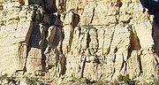
Kaibab Limestone (Upper Permian)
In later Permian time, the Toroweap Basin was invaded by the warm, shallow edge of the vast PanthalassaPanthalassa
Panthalassa , also known as the Panthalassic Ocean, was the vast global ocean that surrounded the supercontinent Pangaea, during the late Paleozoic and the early Mesozoic years. It included the Pacific Ocean to the west and north and the Tethys Ocean to the southeast...
ocean in what local geologists call the Kaibab Sea. At that time, Utah and Wyoming were near the equator
Equator
An equator is the intersection of a sphere's surface with the plane perpendicular to the sphere's axis of rotation and containing the sphere's center of mass....
on the western margin of the supercontinent Pangaea.

Fossil
Fossils are the preserved remains or traces of animals , plants, and other organisms from the remote past...
-rich Kaibab Limestone
Kaibab Limestone
The Kaibab is a geologic formation that is spread across the U.S. states of northern Arizona, southern Utah, east central Nevada and southeast California. This geologic unit is part of the Park City Group in Nevada and Utah and is sometimes locally classified as a geologic group in Utah...
was laid down as a limy ooze in a tropical climate
Climate
Climate encompasses the statistics of temperature, humidity, atmospheric pressure, wind, rainfall, atmospheric particle count and other meteorological elemental measurements in a given region over long periods...
. During this time, sponge
Sea sponge
Sponges are animals of the phylum Porifera . Their bodies consist of jelly-like mesohyl sandwiched between two thin layers of cells. While all animals have unspecialized cells that can transform into specialized cells, sponges are unique in having some specialized cells, but can also have...
s, such as Actinocoelia meandrina, proliferated, only to be buried in lime mud and their internal silica needles (spicules) dissolved and recrystallized to form discontinuous layers of light-colored chert
Chert
Chert is a fine-grained silica-rich microcrystalline, cryptocrystalline or microfibrous sedimentary rock that may contain small fossils. It varies greatly in color , but most often manifests as gray, brown, grayish brown and light green to rusty red; its color is an expression of trace elements...
. In the park, this formation can be found in the Hurricane Cliffs above the Kolob Canyons Visitor Center and in an escarpment
Escarpment
An escarpment is a steep slope or long cliff that occurs from erosion or faulting and separates two relatively level areas of differing elevations.-Description and variants:...
along Interstate 15 as it skirts the park. This is the same formation that rims the Grand Canyon to the south.
Farther to the west, a complex island arc
Island arc
An island arc is a type of archipelago composed of a chain of volcanoes which alignment is arc-shaped, and which are situated parallel and close to a boundary between two converging tectonic plates....
assemblage formed above a subduction zone. To the east, in western Colorado
Colorado
Colorado is a U.S. state that encompasses much of the Rocky Mountains as well as the northeastern portion of the Colorado Plateau and the western edge of the Great Plains...
, a mountain range similar to today’s Himalayas called the Uncompahgre Mountains bordered the Utah lowland. The interfingering of the Kaibab with the White Rim Sandstone, now exposed in Capital Reef National Park area
Geology of the Capitol Reef area
The exposed geology of the Capitol Reef area presents a record of mostly Mesozoic-aged sedimentation in an area of North America in and around Capitol Reef National Park. Nearly 10,000 feet of sedimentary strata are found in the Capitol Reef area, representing nearly 200 million years of...
, to the east suggests that the marine facies of the Kaibab migrated eastward in response to a relative sea-level rise, or transgression (the White Rim is not exposed in the Zion area). The sea moved back and forth across Utah, but by the Middle Permian, the sea had withdrawn and the Kaibab Limestone was exposed to erosion, creating karst topography
Karst topography
Karst topography is a geologic formation shaped by the dissolution of a layer or layers of soluble bedrock, usually carbonate rock such as limestone or dolomite, but has also been documented for weathering resistant rocks like quartzite given the right conditions.Due to subterranean drainage, there...
and channels reaching 30 m (100 ft) in depth.
Moenkopi Formation (Lower Triassic)
Volcano
2. Bedrock3. Conduit 4. Base5. Sill6. Dike7. Layers of ash emitted by the volcano8. Flank| 9. Layers of lava emitted by the volcano10. Throat11. Parasitic cone12. Lava flow13. Vent14. Crater15...
es continued to erupt through the Early Triassic
Triassic
The Triassic is a geologic period and system that extends from about 250 to 200 Mya . As the first period of the Mesozoic Era, the Triassic follows the Permian and is followed by the Jurassic. Both the start and end of the Triassic are marked by major extinction events...
on the north–south trending island arc to the west, which was located along what is now the border between California
California
California is a state located on the West Coast of the United States. It is by far the most populous U.S. state, and the third-largest by land area...
and Nevada
Nevada
Nevada is a state in the western, mountain west, and southwestern regions of the United States. With an area of and a population of about 2.7 million, it is the 7th-largest and 35th-most populous state. Over two-thirds of Nevada's people live in the Las Vegas metropolitan area, which contains its...
. Shallow, marine water stretched from eastern Utah to eastern Nevada over a beveled continental shelf
Continental shelf
The continental shelf is the extended perimeter of each continent and associated coastal plain. Much of the shelf was exposed during glacial periods, but is now submerged under relatively shallow seas and gulfs, and was similarly submerged during other interglacial periods. The continental margin,...
. As the sea withdrew around 230 million years ago, fluvial, mudflat, sabkha, and shallow marine environments developed, depositing gypsum
Gypsum
Gypsum is a very soft sulfate mineral composed of calcium sulfate dihydrate, with the chemical formula CaSO4·2H2O. It is found in alabaster, a decorative stone used in Ancient Egypt. It is the second softest mineral on the Mohs Hardness Scale...
(from lagoon
Lagoon
A lagoon is a body of shallow sea water or brackish water separated from the sea by some form of barrier. The EU's habitat directive defines lagoons as "expanses of shallow coastal salt water, of varying salinity or water volume, wholly or partially separated from the sea by sand banks or shingle,...
evaporite
Evaporite
Evaporite is a name for a water-soluble mineral sediment that result from concentration and crystallization by evaporation from an aqueous solution. There are two types of evaporate deposits, marine which can also be described as ocean deposits, and non-marine which are found in standing bodies of...
s), mudstone
Mudstone
Mudstone is a fine grained sedimentary rock whose original constituents were clays or muds. Grain size is up to 0.0625 mm with individual grains too small to be distinguished without a microscope. With increased pressure over time the platey clay minerals may become aligned, with the...
s, limestones, sandstone
Sandstone
Sandstone is a sedimentary rock composed mainly of sand-sized minerals or rock grains.Most sandstone is composed of quartz and/or feldspar because these are the most common minerals in the Earth's crust. Like sand, sandstone may be any colour, but the most common colours are tan, brown, yellow,...
s, shale
Shale
Shale is a fine-grained, clastic sedimentary rock composed of mud that is a mix of flakes of clay minerals and tiny fragments of other minerals, especially quartz and calcite. The ratio of clay to other minerals is variable. Shale is characterized by breaks along thin laminae or parallel layering...
s, and siltstone
Siltstone
Siltstone is a sedimentary rock which has a grain size in the silt range, finer than sandstone and coarser than claystones.- Description :As its name implies, it is primarily composed of silt sized particles, defined as grains 1/16 - 1/256 mm or 4 to 8 on the Krumbein phi scale...
s.
It took many thousands of thin layers of these sediments to form the 1800 feet (548.6 m) thick Moenkopi Formation
Moenkopi Formation
The Moenkopi is a geological formation that is spread across the U.S. states of New Mexico, northern Arizona, Nevada, southeastern California, eastern Utah and western Colorado. This unit is considered to be a group in Arizona. Part of the Colorado Plateau and Basin and Range, this formation was...
. A prograding shoreline laid down muddy delta sediments which mixed with limy marine deposits. The fossilized plants and animals in the Moenkopi are evidence of a climate shift to a warm tropical setting that may have experienced monsoon
Monsoon
Monsoon is traditionally defined as a seasonal reversing wind accompanied by corresponding changes in precipitation, but is now used to describe seasonal changes in atmospheric circulation and precipitation associated with the asymmetric heating of land and sea...
al, wet-dry conditions.
The Red Canyon Conglomerate, the basal member of the Moenkopi, fills broad east-flowing paleochannels carved into the Kaibab Limestone. Some of these channels are up to several tens of feet deep and may reach 200 ft (61 m) deep in the St. George area. A thin, poorly developed soil, or regolith, formed over the paleotopographic high areas between the channels.
The depositional environment was a nearshore one where the seashore alternated between advance (transgression) and retreat (regression). At Zion, the limestones and fossils of the Timpoweap, Virgin Limestone, and Shnabkaib members of the Moenkopi Formation document transgressive episodes. Unlike the Timpoweap and Virgin Limestone members, the Shnabkaib contains abundant gypsum and interbedded mudstone resulting from deposition in a restricted marine environment with complex watertable fluctuations. Regressive, red-bed layers separate the transgressive strata. Ripple marks, mud cracks, and thinly laminated bedding suggest that these intervening red shale and siltstone units were deposited in tidal flat and coastalplain environments.
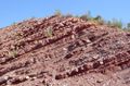
Outcrops of this brightly colored red, brown, and pink banded formation can be seen in the Kolob Canyons section of the park and in butte
Butte
A butte is a conspicuous isolated hill with steep, often vertical sides and a small, relatively flat top; it is smaller than mesas, plateaus, and table landform tables. In some regions, such as the north central and northwestern United States, the word is used for any hill...
s on either side of State Route 9 between Rockville, Utah
Rockville, Utah
Rockville is a town in Washington County, Utah, United States. It is located along the Virgin River near the mouth of Zion Canyon. The city lies just outside of the park boundary for Zion National Park; the park entrance is located approximately 5 miles northeast of the town.-Geography:Rockville...
to the south and Virgin, Utah
Virgin, Utah
Virgin is a town in Washington County, Utah, United States. The population was 394 at the 2000 census. It is located along the Virgin River , not far from Zion National Park. The elevation is...
to the southwest of the park borders. Progressively higher beds are exposed until the top of the formation is reached at the mouth of Parunweap Canyon (when traveling to the park on Route 9).
Chinle Formation (Upper Triassic)
Later, uplift exposed the Moenkopi Formation to erosionErosion
Erosion is when materials are removed from the surface and changed into something else. It only works by hydraulic actions and transport of solids in the natural environment, and leads to the deposition of these materials elsewhere...
and Utah became part of a large interior basin drained by north and northwest-flowing
rivers in the Upper Triassic. Shallow river deposition along with volcanic ash
Volcanic ash
Volcanic ash consists of small tephra, which are bits of pulverized rock and glass created by volcanic eruptions, less than in diameter. There are three mechanisms of volcanic ash formation: gas release under decompression causing magmatic eruptions; thermal contraction from chilling on contact...
eventually became the mineral
Mineral
A mineral is a naturally occurring solid chemical substance formed through biogeochemical processes, having characteristic chemical composition, highly ordered atomic structure, and specific physical properties. By comparison, a rock is an aggregate of minerals and/or mineraloids and does not...
-rich Chinle Formation
Chinle Formation
The Chinle is a geologic formation that is spread across the U.S. states of northern Arizona, Nevada, Utah, western New Mexico, and western Colorado. The Chinle is controversially considered to be synonymous to the Dockum Group in eastern Colorado, eastern New Mexico, southwestern Kansas, the...
. The irregular contact zone, or unconformity
Unconformity
An unconformity is a buried erosion surface separating two rock masses or strata of different ages, indicating that sediment deposition was not continuous. In general, the older layer was exposed to erosion for an interval of time before deposition of the younger, but the term is used to describe...
, between the Chinle and the underlying Moenkopi can be seen between Rockville and Grafton, Utah
Grafton, Utah
Grafton is a ghost town, just south of Zion National Park in Washington County, Utah, United States. Said to be the most photographed ghost town in the West, it has been featured as a location in several films, including 1929's In Old Arizona—the first talkie filmed outdoors—and the...
).
Petrified wood
Petrified wood is the name given to a special type of fossilized remains of terrestrial vegetation. It is the result of a tree having turned completely into stone by the process of permineralization...
and fossils of animals adapted to swamp
Swamp
A swamp is a wetland with some flooding of large areas of land by shallow bodies of water. A swamp generally has a large number of hammocks, or dry-land protrusions, covered by aquatic vegetation, or vegetation that tolerates periodical inundation. The two main types of swamp are "true" or swamp...
y environments, such as phytosaur
Phytosaur
Phytosaurs are an extinct group of large semi-aquatic Late Triassic archosaurs. Phytosaurs belong to the family Phytosauridae and the order Phytosauria. They were long-snouted and heavily armoured, bearing a remarkable resemblance to modern crocodiles in size, appearance, and lifestyle, an example...
s, lungfish
Lungfish
Lungfish are freshwater fish belonging to the Subclass Dipnoi. Lungfish are best known for retaining characteristics primitive within the Osteichthyes, including the ability to breathe air, and structures primitive within Sarcopterygii, including the presence of lobed fins with a well-developed...
, and lacustrine bivalves, have been found in this formation as well as conifer trees, cycad
Cycad
Cycads are seed plants typically characterized by a stout and woody trunk with a crown of large, hard and stiff, evergreen leaves. They usually have pinnate leaves. The individual plants are either all male or all female . Cycads vary in size from having a trunk that is only a few centimeters...
s, fern
Fern
A fern is any one of a group of about 12,000 species of plants belonging to the botanical group known as Pteridophyta. Unlike mosses, they have xylem and phloem . They have stems, leaves, and roots like other vascular plants...
s, and horsetail
Horsetail
Equisetum is the only living genus in the Equisetaceae, a family of vascular plants that reproduce by spores rather than seeds.Equisetum is a "living fossil", as it is the only living genus of the entire class Equisetopsida, which for over one hundred million years was much more diverse and...
s. Relatively plentiful uranium
Uranium
Uranium is a silvery-white metallic chemical element in the actinide series of the periodic table, with atomic number 92. It is assigned the chemical symbol U. A uranium atom has 92 protons and 92 electrons, of which 6 are valence electrons...
ore, such as carnotite
Carnotite
Carnotite is a potassium uranium vanadate radioactive mineral with chemical formula: K222·3H2O. The water content can vary and small amounts of calcium, barium, magnesium, iron, and sodium are often present.-Occurrence:...
and other uranium-bearing minerals, has also been found. The purple, pink, blue, white, yellow, gray, and red colored Chinle also contains shale, gypsum, limestone, sandstone, and quartz
Quartz
Quartz is the second-most-abundant mineral in the Earth's continental crust, after feldspar. It is made up of a continuous framework of SiO4 silicon–oxygen tetrahedra, with each oxygen being shared between two tetrahedra, giving an overall formula SiO2. There are many different varieties of quartz,...
. Iron
Iron
Iron is a chemical element with the symbol Fe and atomic number 26. It is a metal in the first transition series. It is the most common element forming the planet Earth as a whole, forming much of Earth's outer and inner core. It is the fourth most common element in the Earth's crust...
, manganese oxide
Manganese oxide
Manganese oxide is a generic term used to describe a variety of manganese oxides and hydroxides. It may refer to:* Manganese oxide, MnO* Manganese oxide, Mn3O4* Manganese oxide, Mn2O3* Manganese dioxide, , MnO2...
s and copper sulfide
Copper sulfide
Copper sulfides describe a family of chemical compounds and minerals with the formula CuxSy. Both minerals and synthetic materials comprise these compounds. Some copper sulfides are economically important ores....
are often found filling gaps between pebbles. Purplish slopes made of the Chinle can be seen above the town of Rockville.
The sand, gravel
Gravel
Gravel is composed of unconsolidated rock fragments that have a general particle size range and include size classes from granule- to boulder-sized fragments. Gravel can be sub-categorized into granule and cobble...
, and trees which made up these deposits were later strongly cemented by dissolved silica (probably from volcanic ash from the west) in groundwater
Groundwater
Groundwater is water located beneath the ground surface in soil pore spaces and in the fractures of rock formations. A unit of rock or an unconsolidated deposit is called an aquifer when it can yield a usable quantity of water. The depth at which soil pore spaces or fractures and voids in rock...
. Much of the bright coloration of the Chinle is due to soil formation during the Late Triassic. The lowermost member of the Chinle, the Shinarump, consists of a white, gray, and brown conglomerate
Conglomerate (geology)
A conglomerate is a rock consisting of individual clasts within a finer-grained matrix that have become cemented together. Conglomerates are sedimentary rocks consisting of rounded fragments and are thus differentiated from breccias, which consist of angular clasts...
made of coarse sandstone, and thin lenses of sandy mudstone, along with plentiful petrified wood. The Shinarump was laid down in braided streams that flowed through valleys eroded into the underlying Moenkopi Formation. This member of the Chinle forms prominent cliffs with thickness up to 200 feet (61 m), and its name comes from a Native American
Native Americans in the United States
Native Americans in the United States are the indigenous peoples in North America within the boundaries of the present-day continental United States, parts of Alaska, and the island state of Hawaii. They are composed of numerous, distinct tribes, states, and ethnic groups, many of which survive as...
word meaning "wolf's rump" (a reference to the way this member erodes into gray, rounded hills).
A succession of volcanic-ash-rich mudstone and sandstone with a thickness of 350 feet (106.7 m) make up the Petrified Forest Member of the Chinle, which was deposited by lakes, highly sinuous rivers and on the surrounding floodplains. This is the same bright, multicolored part of the Chinle that is exposed in Petrified Forest National Park
Petrified Forest National Park
Petrified Forest National Park is a United States national park in Navajo and Apache counties in northeastern Arizona. The park's headquarters are about east of Holbrook along Interstate 40 , which parallels a railroad line, the Puerco River, and historic U.S. Route 66, all crossing the park...
and the Painted Desert
Painted Desert, Arizona
The Painted Desert is a area of badlands located in Northern Arizona in the United States. The Arizona desert stretches from the Grand Canyon National Park into the Petrified Forest National Park and runs roughly astride and just north of the Little Colorado and the Puerco Rivers...
. Petrified wood is, of course, also common in this member.
Moenave and Kayenta formations (Lower Jurassic)
Early Jurassic uplift created an unconformity above the Chinle Formation that represents about ten million years of missing sedimentation between it and the next formation, the MoenaveMoenave Formation
The Moenave Formation is a Mesozoic geologic formation. Dinosaur remains are among the fossils that have been recovered from the formation, although none have yet been referred to a specific genus.-See also:* List of dinosaur-bearing rock formations...
. Periodic incursions of shallow seas from the north during the Jurassic flooded parts of Wyoming, Montana, and a northeast–southwest trending trough on the Utah/Idaho border. The Moenave was deposited in a variety of river, lake, and flood-plain environments.

The upper member of the Moenave is the pale reddish-brown with a thickness of 75 to 150 ft (22.9 to 45.7 m) and cliff-forming Springdale Sandstone. It was deposited in swifter, larger, and more voluminous streams than the older Dinosaur Canyon Member. Fossils of large sturgeon
Sturgeon
Sturgeon is the common name used for some 26 species of fish in the family Acipenseridae, including the genera Acipenser, Huso, Scaphirhynchus and Pseudoscaphirhynchus. The term includes over 20 species commonly referred to as sturgeon and several closely related species that have distinct common...
-like freshwater fish
Fish
Fish are a paraphyletic group of organisms that consist of all gill-bearing aquatic vertebrate animals that lack limbs with digits. Included in this definition are the living hagfish, lampreys, and cartilaginous and bony fish, as well as various extinct related groups...
have been found in the beds of the Springdale Sandstone. The next member in the Moenave Formation is the thin-bedded Whitmore Point, which is made of mudstone and shale
Shale
Shale is a fine-grained, clastic sedimentary rock composed of mud that is a mix of flakes of clay minerals and tiny fragments of other minerals, especially quartz and calcite. The ratio of clay to other minerals is variable. Shale is characterized by breaks along thin laminae or parallel layering...
. The lower red cliffs visible from the Zion Human History Museum (until 2000 the Zion Canyon Visitor Center) are accessible examples of this formation.
Kayenta Formation
The Kayenta Formation is a geologic layer in the Glen Canyon Group that is spread across the Colorado Plateau province of the United States, including northern Arizona, northwest Colorado, Nevada, and Utah. This rock formation is particularly prominent in southeastern Utah, where it is seen in the...
's sand and silt
Silt
Silt is granular material of a size somewhere between sand and clay whose mineral origin is quartz and feldspar. Silt may occur as a soil or as suspended sediment in a surface water body...
were laid down in early Jurassic
Jurassic
The Jurassic is a geologic period and system that extends from about Mya to Mya, that is, from the end of the Triassic to the beginning of the Cretaceous. The Jurassic constitutes the middle period of the Mesozoic era, also known as the age of reptiles. The start of the period is marked by...
time in slower-moving, intermittent streambeds in a semiarid to tropical environment. Interbedded sandstone, basal conglomerates, siltstones, mudstones, and thin cross-beds are typical channel and floodplain deposits found in the Kayenta. Paleocurrent studies show that the Kayenta rivers flowed in a general westward to southwestward direction.
Fossilized dinosaur
Dinosaur
Dinosaurs are a diverse group of animals of the clade and superorder Dinosauria. They were the dominant terrestrial vertebrates for over 160 million years, from the late Triassic period until the end of the Cretaceous , when the Cretaceous–Paleogene extinction event led to the extinction of...
footprints
Ichnite
An ichnite is a fossilised footprint. This is a type of trace fossil. Over the years, many ichnites have been found, around the world, giving important clues about the behaviour of the animals that made them...
from sauropods have been found in this formation near the Left Fork of North Creek. Mountains in Nevada and California continued to rise in the Lower Jurassic as plate motions forced North America
northward. Eventually, this created a rain shadow
Rain shadow
A rain shadow is a dry area on the lee side of a mountainous area. The mountains block the passage of rain-producing weather systems, casting a "shadow" of dryness behind them. As shown by the diagram to the right, the warm moist air is "pulled" by the prevailing winds over a mountain...
and brought widespread desertification
Desertification
Desertification is the degradation of land in drylands. Caused by a variety of factors, such as climate change and human activities, desertification is one of the most significant global environmental problems.-Definitions:...
. Today the Kayenta is a red and mauve rocky slope-former that can be seen throughout Zion Canyon.
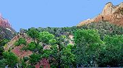
Navajo Formation (Lower to Mid Jurassic)
Jurassic
The Jurassic is a geologic period and system that extends from about Mya to Mya, that is, from the end of the Triassic to the beginning of the Cretaceous. The Jurassic constitutes the middle period of the Mesozoic era, also known as the age of reptiles. The start of the period is marked by...
the Colorado Plateau area's climate
Climate
Climate encompasses the statistics of temperature, humidity, atmospheric pressure, wind, rainfall, atmospheric particle count and other meteorological elemental measurements in a given region over long periods...
increasingly became arid
Arid
A region is said to be arid when it is characterized by a severe lack of available water, to the extent of hindering or even preventing the growth and development of plant and animal life...
until 150,000 square miles (388,000 km²) of western North America
North America
North America is a continent wholly within the Northern Hemisphere and almost wholly within the Western Hemisphere. It is also considered a northern subcontinent of the Americas...
became a huge desert
Desert
A desert is a landscape or region that receives an extremely low amount of precipitation, less than enough to support growth of most plants. Most deserts have an average annual precipitation of less than...
, not unlike the modern Sahara
Sahara
The Sahara is the world's second largest desert, after Antarctica. At over , it covers most of Northern Africa, making it almost as large as Europe or the United States. The Sahara stretches from the Red Sea, including parts of the Mediterranean coasts, to the outskirts of the Atlantic Ocean...
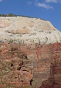
. For perhaps 10 million years sometime around 175 million years ago sand dunes accumulated, reaching their greatest thickness in the Zion Canyon area; about 2,200 feet (670 m) at the Temple of Sinawava (photo) in Zion Canyon.
Most of the sand, made of 98% translucent, rounded-grain quartz
Quartz
Quartz is the second-most-abundant mineral in the Earth's continental crust, after feldspar. It is made up of a continuous framework of SiO4 silicon–oxygen tetrahedra, with each oxygen being shared between two tetrahedra, giving an overall formula SiO2. There are many different varieties of quartz,...
, was transported from coastal sand dunes to the west, in what is now central Nevada
Nevada
Nevada is a state in the western, mountain west, and southwestern regions of the United States. With an area of and a population of about 2.7 million, it is the 7th-largest and 35th-most populous state. Over two-thirds of Nevada's people live in the Las Vegas metropolitan area, which contains its...
. Today the Navajo Sandstone
Navajo Sandstone
Navajo Sandstone is a geologic formation in the Glen Canyon Group that is spread across the U.S. states of northern Arizona, northwest Colorado, and Utah; as part of the Colorado Plateau province of the United States...
is a geographically widespread, pale tan to red cliff and monolith
Monolith
A monolith is a geological feature such as a mountain, consisting of a single massive stone or rock, or a single piece of rock placed as, or within, a monument...
former with very obvious sand dune cross-bedding patterns (photo). Typically the lower part of this remarkably homogeneous formation is reddish from iron oxide
Iron oxide
Iron oxides are chemical compounds composed of iron and oxygen. All together, there are sixteen known iron oxides and oxyhydroxides.Iron oxides and oxide-hydroxides are widespread in nature, play an important role in many geological and biological processes, and are widely utilized by humans, e.g.,...
that percolated from the overlaying iron-rich Temple Cap formation while the upper part of the formation is a pale tan to nearly white color. The other component of the Navajo's weak cement
Cement
In the most general sense of the word, a cement is a binder, a substance that sets and hardens independently, and can bind other materials together. The word "cement" traces to the Romans, who used the term opus caementicium to describe masonry resembling modern concrete that was made from crushed...
matrix is calcium carbonate
Calcium carbonate
Calcium carbonate is a chemical compound with the formula CaCO3. It is a common substance found in rocks in all parts of the world, and is the main component of shells of marine organisms, snails, coal balls, pearls, and eggshells. Calcium carbonate is the active ingredient in agricultural lime,...
, but the resulting sandstone is friable (crumbles easily) and very porous. Cross-bedding is especially evident in the eastern part of the park where Jurassic wind directions changed often. The crosshatched appearance of Checkerboard Mesa is a good example (photo).
Springs, such as Weeping Rock (photo), form in canyon walls made of the porous Navajo Sandstone when water hits and is channeled by the underlying non-porous Kayenta Formation. The principal aquifer
Aquifer
An aquifer is a wet underground layer of water-bearing permeable rock or unconsolidated materials from which groundwater can be usefully extracted using a water well. The study of water flow in aquifers and the characterization of aquifers is called hydrogeology...
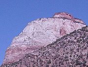
in the region is contained in Navajo Sandstone. Navajo is the most prominent formation exposed in Zion Canyon with the highest exposures being West Temple and Checkerboard Mesa. The monoliths in the sides of Zion Canyon are among the tallest sandstone cliffs in the world.
Temple Cap and Carmel formations (Middle Jurassic)
Sevier orogeny
The Sevier orogeny was a mountain-building event that affected western North America from Canada to the north to Mexico to the south. This orogeny was the result of convergent boundary tectonic activity between approximately 140 million years ago and 50 Ma. The Sevier River area of central Utah...
. At the same time, an inland sea began to encroach on the continent from the north. Broad tidal flats and streams carrying iron oxide-rich mud formed on the margins of the shallow sea to the west, creating the Sinawava member of the Temple Cap Formation. Flat-bedded sandstones, siltstones, and limestones filled depressions left in the underlying eroded strata. Streams eroded the poorly cemented Navajo Sandstone, and water caused the sand to slump.
Desert conditions returned briefly, creating the White Throne member, but encroaching seas again beveled the coastline, forming a regional unconformity. Thin beds of clay
Clay
Clay is a general term including many combinations of one or more clay minerals with traces of metal oxides and organic matter. Geologic clay deposits are mostly composed of phyllosilicate minerals containing variable amounts of water trapped in the mineral structure.- Formation :Clay minerals...
and silt mark the end of this formation. The most prominent outcrops of this formation make up the capstone of West Temple in Zion Canyon. Rain dissolves some of the iron oxide and thus streaks Zion's cliffs red (the red streak seen on the Altar of Sacrifice is a famous example). Temple Cap iron oxide is also the source of the red-orange color of much the lower half of the Navajo Formation.
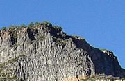
Carmel Formation
The Carmel Formation is a geologic formation in the San Rafael Group that is spread across the U.S. states of Wyoming, Utah, Colorado, north east Arizona and New Mexico...
, 200 to 300 ft (61 to 91.4 m) thick.
Many unique environments were created by the migrating Sevier thrust system, and the four members of the Carmel Formation in southwest Utah capture these changing environments. Both open marine (crinoid
Crinoid
Crinoids are marine animals that make up the class Crinoidea of the echinoderms . Crinoidea comes from the Greek word krinon, "a lily", and eidos, "form". They live both in shallow water and in depths as great as 6,000 meters. Sea lilies refer to the crinoids which, in their adult form, are...
s) and restricted marine (pelecypods, gastropods) environments are represented in the Co-op Creek member. Sandstone and gypsum in the Crystal Creek and Paria River members signal a return to desert conditions in a coastal setting.
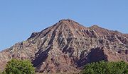
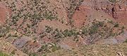
Outcrops of the Carmel Formation are most notably exposed on Horse Ranch Mountain (photo) in the Kolob Canyons section of the park and near Mt. Carmel Junction east of the park. Other formations totaling 2800 feet (853.4 m) thick may have been deposited in the region during Late Jurassic
Jurassic
The Jurassic is a geologic period and system that extends from about Mya to Mya, that is, from the end of the Triassic to the beginning of the Cretaceous. The Jurassic constitutes the middle period of the Mesozoic era, also known as the age of reptiles. The start of the period is marked by...
and Early Cretaceous
Cretaceous
The Cretaceous , derived from the Latin "creta" , usually abbreviated K for its German translation Kreide , is a geologic period and system from circa to million years ago. In the geologic timescale, the Cretaceous follows the Jurassic period and is followed by the Paleogene period of the...
only to be uplifted and entirely removed by erosion.
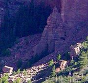
Dakota Sandstone (Lower Cretaceous)
Cretaceous
The Cretaceous , derived from the Latin "creta" , usually abbreviated K for its German translation Kreide , is a geologic period and system from circa to million years ago. In the geologic timescale, the Cretaceous follows the Jurassic period and is followed by the Paleogene period of the...
while the roughly north-south trending Western Interior Basin expanded. Rifting in the Gulf of Mexico
Gulf of Mexico
The Gulf of Mexico is a partially landlocked ocean basin largely surrounded by the North American continent and the island of Cuba. It is bounded on the northeast, north and northwest by the Gulf Coast of the United States, on the southwest and south by Mexico, and on the southeast by Cuba. In...
helped the southern end of the basin to subside, which allowed marine water to advance northward. At the same time, the shoreline advanced inland from the Arctic region. The seas advanced and retreated many times during the Cretaceous until one of the most extensive interior seaways ever, called the Western Interior Seaway
Western Interior Seaway
The Western Interior Seaway, also called the Cretaceous Seaway, the Niobraran Sea, and the North American Inland Sea, was a huge inland sea that split the continent of North America into two halves, Laramidia and Appalachia, during most of the mid- and late-Cretaceous Period...
, drowned much of western North America from the Gulf of Mexico to the Arctic Ocean
Arctic Ocean
The Arctic Ocean, located in the Northern Hemisphere and mostly in the Arctic north polar region, is the smallest and shallowest of the world's five major oceanic divisions...
. The western shoreline of the seaway was in the vicinity of Cedar City, Utah
Cedar City, Utah
As of the census of 2000, there were 20,527 people, 6,486 households, and 4,682 families residing in the city. The population density was 1,021.8 people per square mile . There were 7,109 housing units at an average density of 353.9 per square mile...
while the eastern margin was part of the low-lying, stable platform ramp in Nebraska
Nebraska
Nebraska is a state on the Great Plains of the Midwestern United States. The state's capital is Lincoln and its largest city is Omaha, on the Missouri River....
and Kansas
Kansas
Kansas is a US state located in the Midwestern United States. It is named after the Kansas River which flows through it, which in turn was named after the Kansa Native American tribe, which inhabited the area. The tribe's name is often said to mean "people of the wind" or "people of the south...
.
The pebble to cobble conglomerate
Conglomerate (geology)
A conglomerate is a rock consisting of individual clasts within a finer-grained matrix that have become cemented together. Conglomerates are sedimentary rocks consisting of rounded fragments and are thus differentiated from breccias, which consist of angular clasts...
and tan fossil-rich sandstone of the resulting 100 feet (30.5 m) thick Dakota Sandstone
Dakota Sandstone
The Dakota Sandstone is a general term for an ill-defined early Cretaceous formation of the Rocky Mountains and Great Plains. It consists of sandy, shallow-marine deposits with intermittent mud flat sediments, and occasional stream deposits...
include alluvial fan
Alluvial fan
An alluvial fan is a fan-shaped deposit formed where a fast flowing stream flattens, slows, and spreads typically at the exit of a canyon onto a flatter plain. A convergence of neighboring alluvial fans into a single apron of deposits against a slope is called a bajada, or compound alluvial...
and alluvial plain
Alluvial plain
An alluvial plain is a relatively flat landform created by the deposition of sediment over a long period of time by one or more rivers coming from highland regions, from which alluvial soil forms...
sediments that grade laterally into coastal plain, marginal marine, and marine deposits. A small remnant of the Dakota is exposed on top of the 8766 feet (2,671.9 m) -high Horse Ranch Mountain (photo). This formation is the youngest one exposed in the Zion area but the oldest exposed in Bryce Canyon to the northeast. Deposition continued but the resulting formations were later uplifted and eroded away. The exposed formations in the Bryce Canyon area
Geology of the Bryce Canyon area
The exposed geology of the Bryce Canyon area in Utah shows a record of deposition that covers the last part of the Cretaceous Period and the first half of the Cenozoic era in that part of North America...
likely represent these lost layers.
Regional forces
East–west-directed compression from subduction off the west coast affected the area in later Mesozoic and early TertiaryTertiary
The Tertiary is a deprecated term for a geologic period 65 million to 2.6 million years ago. The Tertiary covered the time span between the superseded Secondary period and the Quaternary...
time by folding and thrust fault
Thrust fault
A thrust fault is a type of fault, or break in the Earth's crust across which there has been relative movement, in which rocks of lower stratigraphic position are pushed up and over higher strata. They are often recognized because they place older rocks above younger...
ing strata. Evidence for the Sevier Orogeny part of this period can be seen in the Taylor Creek area in the Kolob section of the park. Chunks of Moenave strata have been compressed to the point of thrusting themselves over the same formation in the Taylor Creek Thrust Fault Zone, located on the east flank of the Kanarra anticline.
Tensional forces forming the Basin and Range
Basin and Range
The Basin and Range Province is a vast physiographic region defined by a unique topographic expression. Basin and Range topography is characterized by abrupt changes in elevation, alternating between narrow faulted mountain chains and flat arid valleys or basins...
physiogeographic province to the west about 20 to 25 million years ago in Tertiary time created the two faults that bound the Markagunt Plateau
Markagunt Plateau
The Markagunt Plateau is an plateau located in southwestern Utah between Interstate 15 and U.S. Route 89. It is one of the plateaus that make up the High Plateaus Section of the Colorado Plateau. The plateau encompasses Cedar Breaks National Monument and is part of Cedar Mountain District of...
(which underlies the park): the Sevier Fault on the east and the Hurricane Fault on the west. The Hurricane fault zone is a major, active, steeply west-dipping normal fault that stretches at least 155 miles (250 km) from south of the Grand Canyon northward to Cedar City, Utah
Cedar City, Utah
As of the census of 2000, there were 20,527 people, 6,486 households, and 4,682 families residing in the city. The population density was 1,021.8 people per square mile . There were 7,109 housing units at an average density of 353.9 per square mile...
. Along the southern boundary of the park, tectonic displacement along this fault is about 3,600 ft (1,098 m). Several other normal faults also developed on the plateau.
Subsequent uplift
Tectonic uplift
Tectonic uplift is a geological process most often caused by plate tectonics which increases elevation. The opposite of uplift is subsidence, which results in a decrease in elevation. Uplift may be orogenic or isostatic.-Orogenic uplift:...
of the Colorado Plateau
Colorado Plateau
The Colorado Plateau, also called the Colorado Plateau Province, is a physiographic region of the Intermontane Plateaus, roughly centered on the Four Corners region of the southwestern United States. The province covers an area of 337,000 km2 within western Colorado, northwestern New Mexico,...
and tilting of the Markagunt Plateau started 13 million years ago. This steepened the stream gradient
Stream gradient
Stream gradient is the grade measured by the ratio of drop in a stream per unit distance, usually expressed as feet per mile or metres per kilometre.-Hydrology and geology:A high gradient indicates a steep slope and rapid flow of water Stream gradient is the grade (slope) measured by the ratio of...
of the ancestral Virgin River
Virgin River
The Virgin River is a tributary of the Colorado River in the U.S. states of Utah, Nevada, and Arizona. The river is about long. It was designated Utah's first wild and scenic river in 2009, during the centennial celebration of Zion National Park.-Course:...
(Zion Canyon section of the park), and Taylor and La Verkin creeks (Kolob Canyons section of the park), causing them to flow and downcut
Downcutting
Downcutting, also called erosional downcutting or downward erosion or vertical erosion is a geological process that deepens the channel of a stream or valley by removing material from the stream's bed or the valley's floor. How fast downcutting occurs depends on the stream's base level, which is...
faster into the underlying Markagunt Plateau. Downcutting continues to be especially rapid after heavy rainstorms and winter runoff when the water contains large amounts of suspended and abrasive sand grains. Uplift and downcutting are so fast that slot canyon
Slot canyon
A slot canyon is a narrow canyon, formed by the wear of water rushing through rock. A slot canyon is significantly deeper than it is wide. Some slot canyons can measure less than one metre across at the top but drop more than 30 m to the floor of the canyon.Most slot canyons are formed in...
s (very narrow river-cut features with vertical walls), such as the Zion Narrows
The Narrows (Zion National Park)
The Narrows in Zion National Park, is a section of canyon on the North Fork of the Virgin River. The hike of The Narrows is one of the premier hikes on the Colorado Plateau...
, formed.
Volcanic activity
Explosive andesiticAndesite
Andesite is an extrusive igneous, volcanic rock, of intermediate composition, with aphanitic to porphyritic texture. In a general sense, it is the intermediate type between basalt and dacite. The mineral assemblage is typically dominated by plagioclase plus pyroxene and/or hornblende. Magnetite,...
volcanism dominated the area to the west of Zion during Oligocene
Oligocene
The Oligocene is a geologic epoch of the Paleogene Period and extends from about 34 million to 23 million years before the present . As with other older geologic periods, the rock beds that define the period are well identified but the exact dates of the start and end of the period are slightly...
and early Miocene
Miocene
The Miocene is a geological epoch of the Neogene Period and extends from about . The Miocene was named by Sir Charles Lyell. Its name comes from the Greek words and and means "less recent" because it has 18% fewer modern sea invertebrates than the Pliocene. The Miocene follows the Oligocene...
time and probably inundated the region with hundreds of feet of welded tuff that has since eroded away. Three of these tuff layers are preserved on top of Brainhead Peak. About 21 million years ago the Pine Valley laccolith
Laccolith
A laccolith is a sheet intrusion that has been injected between two layers of sedimentary rock. The pressure of the magma is high enough that the overlying strata are forced upward, giving the laccolith a dome or mushroom-like form with a generally planar base.Laccoliths tend to form at relatively...
formed. This typical mushroom-shaped laccolith is one of the largest intrusions of this type in the world. Debris flows carried boulders of this intrusion onto the Upper Kolob Plateau indicating that the Hurricane Cliffs could not have been present at the time.

Pleistocene
The Pleistocene is the epoch from 2,588,000 to 11,700 years BP that spans the world's recent period of repeated glaciations. The name pleistocene is derived from the Greek and ....
time basalt
Basalt
Basalt is a common extrusive volcanic rock. It is usually grey to black and fine-grained due to rapid cooling of lava at the surface of a planet. It may be porphyritic containing larger crystals in a fine matrix, or vesicular, or frothy scoria. Unweathered basalt is black or grey...
ic lava flowed intermittently in the area, taking advantage of uplift-created weaknesses in the Earth
Earth
Earth is the third planet from the Sun, and the densest and fifth-largest of the eight planets in the Solar System. It is also the largest of the Solar System's four terrestrial planets...
's crust. Volcanic activity was concentrated along the Hurricane Fault west of the park that today parallels Interstate 15. Evidence of the oldest flows can be seen at Lava Point and rocks from the youngest are found at the lower end of Cave Valley. Some cinder cone
Cinder cone
According to the , Cinder Cone is the proper name of 1 cinder cone in Canada and 7 cinder cones in the United States:In Canada: Cinder Cone In the United States:...
s were constructed much later in the southwest corner of the park.
Some of these lava flows blocked rivers and streams, impounding small lakes and ephemeral ponds in the process. About 100,000 years ago, basalt from the largest cinder cone
Cinder cone
According to the , Cinder Cone is the proper name of 1 cinder cone in Canada and 7 cinder cones in the United States:In Canada: Cinder Cone In the United States:...
in the park, Crater Hill, flowed over the area. The lava traveled into Coalpits and Scoggins Washes to the south and accumulated to a depth of over 400 ft (122 m) in the ancestral Virgin River valley near the present-day ghost town of Grafton, Utah
Grafton, Utah
Grafton is a ghost town, just south of Zion National Park in Washington County, Utah, United States. Said to be the most photographed ghost town in the West, it has been featured as a location in several films, including 1929's In Old Arizona—the first talkie filmed outdoors—and the...
. Water impounded behind the two blockages, forming Coalpits Lake and Lake Grafton respectively.
Lake Grafton was the largest of at least 14 lakes that have periodically formed in the park (most were from landslides; see below). Thirteen lava flows are mapped in and near Zion dating from 1.5 million to 100,000 years ago. More recent flows of less than 10,000 years in age occurred north of Zion and east of Cedar Breaks National Monument
Cedar Breaks National Monument
Cedar Breaks National Monument is a U.S. National Monument located in the U.S. state of Utah near Cedar City. Cedar Breaks is a natural amphitheater canyon, stretching across , with a depth of over . The elevation of the rim of the canyon is over above sea level.The eroded rock of the canyon is...
.
Erosion and canyon formation
Mass wasting
Mass wasting, also known as slope movement or mass movement, is the geomorphic process by which soil, regolith, and rock move downslope under the force of gravity. Types of mass wasting include creep, slides, flows, topples, and falls, each with its own characteristic features, and taking place...
; sediment-rich and abrasive flood stage waters would undermine cliffs until vertical slabs of rock sheared away. This process continues to be especially efficient with the vertically jointed Navajo Sandstone.
All erosion types took advantage of preexisting weaknesses in the rock such as rock type, amount of lithification, and the presence of cracks or joints in the rock. Basalt flows concentrated in valleys but subsequent erosion removed sedimentary rock that once stood at higher elevations. The resulting inverted topography
Inverted topography
Inverted topography or topographic inversion refers to landscape features that have reversed their elevation relative to other features. It most often occurs when low areas of a landscape become filled with lava or sediment that hardens into material that is more resistant to erosion than the...
consists of ridges capped by basalt which are separated by adjacent drainages.
In all about 6000 feet (1,828.8 m) of sediment were removed from atop the youngest exposed formation in the park (the Late Cretaceous-aged Dakota Sandstone). The Virgin River carved out 1300 feet (396.2 m) of sediment in about 1 million years.Corresponding to a rate of erosion of about 40 cm per 1,000 years (1.3 ft/1,000 yr) This is a very high rate of downcutting, about the same rate as occurred in Grand Canyon
Grand Canyon
The Grand Canyon is a steep-sided canyon carved by the Colorado River in the United States in the state of Arizona. It is largely contained within the Grand Canyon National Park, the 15th national park in the United States...
during its most rapid period of erosion. About 1 million years ago, Zion Canyon was only about half as deep as it is today in the vicinity of Zion Lodge. Assuming that erosion was fairly constant over the past 2 million years, then the upper half of Zion Canyon was carved between about 1 and 2 million years ago and only the upper half of the Great White Throne was exposed 1 million years ago and The Narrows were yet to form.
Downcutting and canyon widening continue today as the process of erosion continues to try to reduce the topography to sea level. In 1998 a flash flood temporarily increased the Virgin River's flow rate from 200 to 4,500 ft³/s (6 to 125 m³/s). Geologists estimate that the Virgin River can cut another thousand feet (300 m) before it loses the ability to transport sediment to the Colorado River to the south. However, additional uplift will probably increase this figure.
Landslides and earthquakes
Valley
In geology, a valley or dale is a depression with predominant extent in one direction. A very deep river valley may be called a canyon or gorge.The terms U-shaped and V-shaped are descriptive terms of geography to characterize the form of valleys...
. About 7,000 years ago, the relatively thin wall between two closely spaced joints in the Navajo Sandstone collapsed. The resulting Sand Bench landslide blocked Zion Canyon just east of The Sentinel, creating Sentinel Lake. Another notable stand was created about 4,000 years ago when Sentinel Slide impounded the North Fork Virgin River, creating a lake that backed up to Weeping Rock. The current site of Zion Lodge
Zion Lodge
Zion Lodge is located in Zion National Park. The lodge was designed in 1924 as a compromise solution between its developer, the Utah Parks Company, which wanted a large hotel, and National Park Service director Stephen Mather, who desired smaller-scale development...
was under about 200 feet (61 m) of water for around 700 years. Evidence of valley floors created by these lakes can be seen from Zion Canyon Scenic Drive south of Zion Lodge near Sentinel Slide. Recent landslides in 1923, 1941, and 1995 have temporarily dammed the Virgin River. Prior to the initial Sand Bench landslide, the Virgin River flowed 70 ft (21 m) lower in elevation than it does today.
The area is periodically rocked by mild to moderate earthquake
Earthquake
An earthquake is the result of a sudden release of energy in the Earth's crust that creates seismic waves. The seismicity, seismism or seismic activity of an area refers to the frequency, type and size of earthquakes experienced over a period of time...
s, which often trigger landslide
Landslide
A landslide or landslip is a geological phenomenon which includes a wide range of ground movement, such as rockfalls, deep failure of slopes and shallow debris flows, which can occur in offshore, coastal and onshore environments...
s. For example, on September 2, 1992 a Richter Magnitude 5.8 earthquake caused 14 million cubic meters (18 million cubic yards) of mostly Moenave Formation to slide downslope atop the weak claystone of the Petrified Forest member of the Chinle Formation. The quake was centered on the Washington Fault, about 30 miles (48.3 km) southwest. Three houses and two water tanks were destroyed when the slope they were built on dropped 98 feet (29.9 m) and extended laterally a similar distance over a period of several hours. The landslide is visible just outside the park's entrance in Springdale, Utah
Springdale, Utah
Springdale is a town in Washington County, Utah, United States. The population was 457 at the 2000 census. It is located immediately outside the boundaries of Zion National Park, and is oriented around the resulting tourist industry. It was originally settled as a Mormon farming community in 1862...
.
External links
- Zion National Park: Geologic History, National Park Service
- Zion National Park: Geologic Resource Evaluation Report, National Park Service