

Andrade, California
Encyclopedia
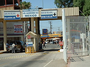
Andrade is a small unincorporated
town in the southeasternmost corner of the state of California
, in Imperial County. It is directly across the border from Los Algodones
, the northernmost town of the municipality of Mexicali
, in Baja California
, and in all of Mexico
. The ZIP Code is 92283. The community is inside area code 760
.
Andrade is named after Mexican General Guillermo Andrade. The General sold the land for the settlement to the California Development Company. The town was named in 1912 with establishment of the post office
.
A post office operated at Andrade from 1909 to 1910 and from 1912 to 1942. The name Cantu commemorated Col. Esteban Cantu, governor of the northern most district of Baja California
from 1915 to 1920.
 As of the year 2000, it had a population of 59, 74.6% of whom were Hispanic or Latino.
The community is located entirely within the Fort Yuma Indian Reservation
.
Unincorporated area
In law, an unincorporated area is a region of land that is not a part of any municipality.To "incorporate" in this context means to form a municipal corporation, a city, town, or village with its own government. An unincorporated community is usually not subject to or taxed by a municipal government...
town in the southeasternmost corner of the state of California
California
California is a state located on the West Coast of the United States. It is by far the most populous U.S. state, and the third-largest by land area...
, in Imperial County. It is directly across the border from Los Algodones
Los Algodones, Baja California
Los Algodones, Baja California, is a small Mexican town located on the extreme northeastern tip of the municipality of Mexicali, approximately west of Yuma, Arizona, USA. Its official name is Vicente Guerrero, although most people use Algodones when referring to it. It reported a population of...
, the northernmost town of the municipality of Mexicali
Municipality of Mexicali
Mexicali Municipality is a municipality in the Mexican state of Baja California. Its municipal seat is located in the city of Mexicali. According to the 2010 census, it had a population of 956,826 inhabitants, and according to the 2000 census, it had 764,602 inhabitants, which means an increase...
, in Baja California
Baja California
Baja California officially Estado Libre y Soberano de Baja California is one of the 31 states which, with the Federal District, comprise the 32 Federal Entities of Mexico. It is both the northernmost and westernmost state of Mexico. Before becoming a state in 1953, the area was known as the North...
, and in all of Mexico
Mexico
The United Mexican States , commonly known as Mexico , is a federal constitutional republic in North America. It is bordered on the north by the United States; on the south and west by the Pacific Ocean; on the southeast by Guatemala, Belize, and the Caribbean Sea; and on the east by the Gulf of...
. The ZIP Code is 92283. The community is inside area code 760
Area code 760
Image:Area_code_442.svg|right|Map of California area codes in blue with 442/760 in redrect 65 82 92 100 Area code 916rect 220 242 245 256 Area code 909rect 243 274 265 287 Area code 951rect 136 323 160 338 Area code 858...
.
Andrade is named after Mexican General Guillermo Andrade. The General sold the land for the settlement to the California Development Company. The town was named in 1912 with establishment of the post office
Post office
A post office is a facility forming part of a postal system for the posting, receipt, sorting, handling, transmission or delivery of mail.Post offices offer mail-related services such as post office boxes, postage and packaging supplies...
.
A post office operated at Andrade from 1909 to 1910 and from 1912 to 1942. The name Cantu commemorated Col. Esteban Cantu, governor of the northern most district of Baja California
Baja California
Baja California officially Estado Libre y Soberano de Baja California is one of the 31 states which, with the Federal District, comprise the 32 Federal Entities of Mexico. It is both the northernmost and westernmost state of Mexico. Before becoming a state in 1953, the area was known as the North...
from 1915 to 1920.
The community is located entirely within the Fort Yuma Indian Reservation
Fort Yuma Indian Reservation
The Fort Yuma Indian Reservation is a part of the traditional lands of the Quechan people. Established in 1884, the reservation, at , has a land area of 178.197 km² in southeastern Imperial County, California, and western Yuma County, Arizona, near the city of Yuma, Arizona. Both the county...
.