

Amphoe Thai Charoen
Encyclopedia
Thai Charoen is a district of Yasothon Province
in northeastern Thailand
.
) of Loeng Nok Tha
, was established as a minor district (king amphoe) on April 1, 1992, comprising 5 subdistricts formerly of Loeng Nok Tha.
On October 11, 1997, Thai Charoen was raised to district (amphoe
) status, becoming Yasothon's 9th and Thailand's 784th district.
The area has been home to the Roman Catholic St Michael's Church, Songyae
, since AD 1908.
, Kut Chum
, Loeng Nok Tha
, of Yasothon Province, Senangkhanikhom
and Mueang Amnat Charoen
of Amnat Charoen Province
.
), which comprise 48 villages (muban
).
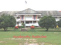 The Thai Charoen District Office is located at:
Khamtoei-Nakham Road
T. Thai Charoen
A. Thai Charoen
Yasothon 35120
Yasothon Province
Yasothon is one of the provinces of Thailand, located in the North-East of Thailand on the Chi River. Neighboring provinces are Mukdahan, Amnat Charoen, Ubon Ratchathani, Sisaket and Roi Et.-Geography:...
in northeastern Thailand
Thailand
Thailand , officially the Kingdom of Thailand , formerly known as Siam , is a country located at the centre of the Indochina peninsula and Southeast Asia. It is bordered to the north by Burma and Laos, to the east by Laos and Cambodia, to the south by the Gulf of Thailand and Malaysia, and to the...
.
History
Thai Charoen, formerly a subdistrict (tambonTambon
Tambon is a local government unit in Thailand. Below district and province , they form the third administrative subdivision level. As of the 2009 there are 7255 tambon, not including the 169 khwaeng of Bangkok, which are set at the same administrative level, thus every district contains 8-10 tambon...
) of Loeng Nok Tha
Amphoe Loeng Nok Tha
Loeng Nok Tha is a district of Yasothon Province in northeastern Thailand. Loeng Nok Tha town, the administrative center of the district, lies 69 km from Mueang Yasothon, and approximately 600 km from Bangkok.-History:...
, was established as a minor district (king amphoe) on April 1, 1992, comprising 5 subdistricts formerly of Loeng Nok Tha.
On October 11, 1997, Thai Charoen was raised to district (amphoe
Amphoe
An amphoe is the second level administrative subdivision of Thailand. Usually translated as district, amphoe make up the provinces, and are analogous to a county seat...
) status, becoming Yasothon's 9th and Thailand's 784th district.
The area has been home to the Roman Catholic St Michael's Church, Songyae
St Michael's Church, Songyae
St Michael's Church, Songyae is aRoman Catholic parish church in the northeastern Thai village of,subdistrict,Thai Charoendistrict,Yasothon Province indicates a fen; swampy or marshy land; is dialect for a group;...
, since AD 1908.
Geography
Neighboring districts are (from the south clockwise) Pa TioAmphoe Pa Tio
-History:Around 1889 there was an influx of Lao settlers into the Isan region after a large area of Thailand east of the Mekong River was ceded to the French. Among the villages established in this migration was Ban Pa Tio....
, Kut Chum
Amphoe Kut Chum
Kut Chum is a district of Yasothon Province in northeastern Thailand.-History:The village of Kut Chum was established in 1912. A minor district Kut Chum was established on August 1, 1961...
, Loeng Nok Tha
Amphoe Loeng Nok Tha
Loeng Nok Tha is a district of Yasothon Province in northeastern Thailand. Loeng Nok Tha town, the administrative center of the district, lies 69 km from Mueang Yasothon, and approximately 600 km from Bangkok.-History:...
, of Yasothon Province, Senangkhanikhom
Amphoe Senangkhanikhom
Senangkhanikhom is a district in the northern part of Amnat Charoen Province, northeastern Thailand.-Geography:Neighboring districts are Chanuman, Mueang Amnat Charoen of Amnat Charoen Province, Thai Charoen and Thai Charoen of Yasothon Province.-History:The minor district was created on...
and Mueang Amnat Charoen
Amphoe Mueang Amnat Charoen
Mueang Amnat Charoen is the capital district of Amnat Charoen Province, northeastern Thailand.-History:Originally Amnat Charoen was a Mueang under Mueang Khemarat. In the thesaphiban administrative reforms around 1900 it was reassigned to Ubon Ratchathani and converted into a district. It was...
of Amnat Charoen Province
Amnat Charoen Province
Amnat Charoen is one of the north-eastern provinces of Thailand. Neighboring provinces are Ubon Ratchathani, Yasothon and Mukdahan. To the east it borders Salavan of Laos.-Geography:...
.
Administration
The district is subdivided into 5 subdistricts (tambonTambon
Tambon is a local government unit in Thailand. Below district and province , they form the third administrative subdivision level. As of the 2009 there are 7255 tambon, not including the 169 khwaeng of Bangkok, which are set at the same administrative level, thus every district contains 8-10 tambon...
), which comprise 48 villages (muban
Muban
Muban is the lowest administrative subdivision of Thailand. Usually translated as village, they are the subdivision of tambon. As of 2008, there are 74944 administrative villages in Thailand. As of the 1990 census, the average village consisted of 144 households or 746 persons.A muban does not...
).
|
District office
Khamtoei-Nakham Road
T. Thai Charoen
A. Thai Charoen
Yasothon 35120
District officers
The district officers (nai amphoe) of Thai Charoen:- Mr. Nirat Ratna (นายนิราศ รัตนะ) November 17, 1997-November 19, 1999
- Mr. Narong Sombunsut (นายณรงค์ สมบูรณ์สุทธิ์) November 29, 1999-October 5, 2003
- Mr. Wichak Chinkhotphong (นายวิจักขณ์ ชินโคตพงษ์) October 6, 2003-October 31, 2004
- Mr. Buntham Loetsukhikasem (นายบุญธรรม เลิศสุขีเกษม) November 1, 2004-Present
Education
The secondary schools in Amphoe Thai Charoen are:- Kham Toei Witthaya School (โรงเรียนคำเตยวิทยา)
- Nam Kham Witthaya School (โรงเรียนน้ำคำวิทยา)
- Songyae Wittaya (โรงเรียนซ่งแย้วิทยา)
External links
- ThaiCharoen.net (in Thai).
- amphoe.com