
Amphoe Pathio
Encyclopedia
Pathio is a district (Amphoe
) in the northern part of
Chumphon Province
, southern Thailand
.
, Tha Sae
of Chumphon Province and Bang Saphan Noi
of Prachuap Khiri Khan Province
. To the east is the Gulf of Thailand
.
), which are further subdivided into 70 villages (muban
). There are three townships (thesaban tambon) - Pathio covers parts of tambon Bang Son and Thale Sap, Map Ammarit parts of tambon Don Yang, Sa Phli parts of the same-named tambon. There are further 7 Tambon administrative organizations (TAO).
Amphoe
An amphoe is the second level administrative subdivision of Thailand. Usually translated as district, amphoe make up the provinces, and are analogous to a county seat...
) in the northern part of
Chumphon Province
Chumphon Province
Chumphon ) is one of the southern provinces of Thailand, at the shore of the Gulf of Thailand. Neighboring provinces are Prachuap Khiri Khan, Surat Thani and Ranong...
, southern Thailand
Thailand
Thailand , officially the Kingdom of Thailand , formerly known as Siam , is a country located at the centre of the Indochina peninsula and Southeast Asia. It is bordered to the north by Burma and Laos, to the east by Laos and Cambodia, to the south by the Gulf of Thailand and Malaysia, and to the...
.
Geography
Neighboring districts are (from the south clockwise) Mueang ChumphonAmphoe Mueang Chumphon
Mueang Chumphon is the capital district of Chumphon Province, southern Thailand.-Geography:Neighboring districts are Sawi of Chumphon Province, Kra Buri of Ranong Province, Tha Sae and Pathio of Chumphon Province again.-Administration:The district is subdivided into 17 subdistricts , which are...
, Tha Sae
Amphoe Tha Sae
Tha Sae is a district in the northwestern part ofChumphon Province, southern Thailand.-History:Mueang Tha Sae was under Mueang Chumphon, with its governor having the rank Phra. King Chulalongkorn downgraded Mueang Tha Sae to a district of Chumphon province. In 1920 the government downgraded Tha...
of Chumphon Province and Bang Saphan Noi
Amphoe Bang Saphan Noi
Bang Saphan Noi or Bangsaphan Noi is the southernmost district of Prachuap Khiri Khan Province, central Thailand.-History:The minor district Bang Saphan Noi was split off from Bang Saphan district on June 10, 1974....
of Prachuap Khiri Khan Province
Prachuap Khiri Khan Province
Prachuap Khiri Khan is one of the central provinces of Thailand. Neighboring provinces are Phetchaburi in the north and Chumphon in the south. To the west it borders Tanintharyi Division of Myanmar....
. To the east is the Gulf of Thailand
Gulf of Thailand
The Gulf of Thailand , also known in to Malays as Teluk Siam literally meant Gulf of Siam, is a shallow arm of the South China Sea.-Geography:...
.
Administration
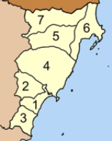
The district is subdivided into 7 subdistricts (tambonTambon
Tambon is a local government unit in Thailand. Below district and province , they form the third administrative subdivision level. As of the 2009 there are 7255 tambon, not including the 169 khwaeng of Bangkok, which are set at the same administrative level, thus every district contains 8-10 tambon...
), which are further subdivided into 70 villages (muban
Muban
Muban is the lowest administrative subdivision of Thailand. Usually translated as village, they are the subdivision of tambon. As of 2008, there are 74944 administrative villages in Thailand. As of the 1990 census, the average village consisted of 144 households or 746 persons.A muban does not...
). There are three townships (thesaban tambon) - Pathio covers parts of tambon Bang Son and Thale Sap, Map Ammarit parts of tambon Don Yang, Sa Phli parts of the same-named tambon. There are further 7 Tambon administrative organizations (TAO).
|
 |