
Amphoe Kantang
Encyclopedia
Kantang is a district (Amphoe
) in the western part of Trang Province
, Thailand
.
) of Trang is still located at its original location at Khuan Thani.
, Mueang Trang
and Yan Ta Khao
of Trang Province. To the southwest is the Andaman Sea
.
The district is located at the mouth of the Trang River.
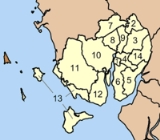
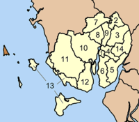 The district is subdivided into 14 subdistricts (tambon
), which are further subdivided into 83 villages (muban
). The town (thesaban mueang) Kantang covers the whole tambon Kantang. There are further further 13 Tambon administrative organizations (TAO).
Amphoe
An amphoe is the second level administrative subdivision of Thailand. Usually translated as district, amphoe make up the provinces, and are analogous to a county seat...
) in the western part of Trang Province
Trang Province
Trang is one of the southern provinces of Thailand, at the western shore of the Malay Peninsula to the Andaman Sea. Neighboring provinces are Krabi, Nakhon Si Thammarat, Phatthalung and Satun....
, Thailand
Thailand
Thailand , officially the Kingdom of Thailand , formerly known as Siam , is a country located at the centre of the Indochina peninsula and Southeast Asia. It is bordered to the north by Burma and Laos, to the east by Laos and Cambodia, to the south by the Gulf of Thailand and Malaysia, and to the...
.
History
Kantang (Malay: Gantang) was the original capital of Trang Province, at first in Khuan Thani, and then from 1893-1916 to the coastal Kantang itself. As the area was prone to floodings the capital was finally moved further inland to its present location. The city pillar shrine (Lak MueangLak Mueang
Lak Mueang are City pillars found in most cities of Thailand. Usually housed in a shrine which is also believed to house Chao Pho Lak Mueang , the city spirit deity; it is held in high esteem by citizens....
) of Trang is still located at its original location at Khuan Thani.
Geography
Neighboring districts are (from the north clockwise) SikaoAmphoe Sikao
Sikao is a district in the northwestern part of Trang Province, Thailand.-History:Sikao district was established in 1887. The present district office was officially opened March 1, 1987...
, Mueang Trang
Amphoe Mueang Trang
Mueang Trang Mueang Trang Mueang Trang ( , also Mueang Thap Thiang ( ) is the capital district ( Amphoe Mueang ) of Trang Province, Thailand. The city (thesaban nakhon) has a population of 59,637 (2005) and covers the whole tambon Thap Thiang of Mueang Trang district....
and Yan Ta Khao
Amphoe Yan Ta Khao
-Geography:Neighboring districts are Palian, Kantang, Mueang Trang and Na Yong of Trang Province, Srinagarindra and Kong Ra of Phatthalung Province.-History:...
of Trang Province. To the southwest is the Andaman Sea
Andaman Sea
The Andaman Sea or Burma Sea is a body of water to the southeast of the Bay of Bengal, south of Burma, west of Thailand and east of the Andaman Islands, India; it is part of the Indian Ocean....
.
The district is located at the mouth of the Trang River.
Administration
Tambon
Tambon is a local government unit in Thailand. Below district and province , they form the third administrative subdivision level. As of the 2009 there are 7255 tambon, not including the 169 khwaeng of Bangkok, which are set at the same administrative level, thus every district contains 8-10 tambon...
), which are further subdivided into 83 villages (muban
Muban
Muban is the lowest administrative subdivision of Thailand. Usually translated as village, they are the subdivision of tambon. As of 2008, there are 74944 administrative villages in Thailand. As of the 1990 census, the average village consisted of 144 households or 746 persons.A muban does not...
). The town (thesaban mueang) Kantang covers the whole tambon Kantang. There are further further 13 Tambon administrative organizations (TAO).
| No. | Name | Thai | Villages | Inh. Population A population is all the organisms that both belong to the same group or species and live in the same geographical area. The area that is used to define a sexual population is such that inter-breeding is possible between any pair within the area and more probable than cross-breeding with individuals... |
|---|---|---|---|---|
| 1. | Kantang | กันตัง | ||
| 13,225 | ||||
| 2. | Khuan Thani | ควนธานี | 6 | 4,630 |
| 3. | Bang Mak | บางหมาก | 6 | 5,395 |
| 4. | Bang Pao | บางเป้า | 7 | 9,402 |
| 5. | Wang Won | วังวน | 5 | 3,991 |
| 6. | Kantang Tai | กันตังใต้ | 6 | 6,972 |
| 7. | Khok Yang | โคกยาง | 8 | 4,293 |
| 8. | Khlong Lu | คลองลุ | 7 | 4,069 |
| 9. | Yan Sue | ย่านซื่อ | 4 | 2,143 |
| 10. | Bo Nam Ron | บ่อน้ำร้อน | 9 | 9,039 |
| 11. | Bang Sak | บางสัก | 6 | 5,698 |
| 12. | Na Kluea | นาเกลือ | 6 | 4,299 |
| 13. | Ko Libong | เกาะลิบง | 8 | 6,843 |
| 14. | Khlong Chi Lom | คลองชีล้อม | 5 | 4,286 |
External links
- amphoe.com (Thai)