
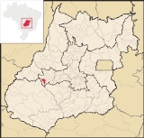
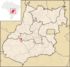
Amorinópolis
Encyclopedia
| Amorinópolis | |
|---|---|
| State | Goiás Goiás Goiás is a state of Brazil, located in the central part of the country. The name Goiás comes from the name of an indigenous community... |
| Area: | 409.9 km² |
| Population: | 3,527 (IBGE 2007) |
| Urban population: | 2,307 (2007) |
| Population density: | 8.63 inhab/km² (2007) |
| Elevation: | 641m above sea level |
| Postcode (CEP): | 76140-000 |
| Became a city: | 1958 |
| Mayor: | Maria Aparecida Leite de Andrade (2005) |
| IBGE statistical Microregion: | Iporá Microregion Iporá Microregion The Iporá Microregion is a geographical region in central-western Goiás state, Brazil. The most important city is Iporá. For a map see -Important Data :*Population: 58,845 *Cities: 10*Total Area: 7,096.60 km²... |
| Distance to Goiânia Goiânia -Climate:The city has a tropical wet and dry climate with an average temperature of . There's a wet season, from October to April, and a dry one, from May to September. Annual rainfall is around 1,520 mm.... : |
244 km. |
| Website: | none (March 2008) |
Town
A town is a human settlement larger than a village but smaller than a city. The size a settlement must be in order to be called a "town" varies considerably in different parts of the world, so that, for example, many American "small towns" seem to British people to be no more than villages, while...
and municipality
Municipality
A municipality is essentially an urban administrative division having corporate status and usually powers of self-government. It can also be used to mean the governing body of a municipality. A municipality is a general-purpose administrative subdivision, as opposed to a special-purpose district...
in eastern Goiás
Goiás
Goiás is a state of Brazil, located in the central part of the country. The name Goiás comes from the name of an indigenous community...
state, Brazil
Brazil
Brazil , officially the Federative Republic of Brazil , is the largest country in South America. It is the world's fifth largest country, both by geographical area and by population with over 192 million people...
.
Location
The distance to the regional center of (IporáIporá
Iporá is a small city and municipality in west-central Goiás state, Brazil. The population was 31,060 in a total area of 1,026.4 km² . It is known as the City of the Clear Waters because of its many streams and rivers.-Location:...
) is 19 km.
Highway connections from Goiânia
Goiânia
-Climate:The city has a tropical wet and dry climate with an average temperature of . There's a wet season, from October to April, and a dry one, from May to September. Annual rainfall is around 1,520 mm....
are made by state highway BR-069 west from Goiânia
Goiânia
-Climate:The city has a tropical wet and dry climate with an average temperature of . There's a wet season, from October to April, and a dry one, from May to September. Annual rainfall is around 1,520 mm....
, through Trindade
Trindade
-Transportation:Trindade are linked with São Tomé and Príncipe's only highways linking to the capital city of São Tomé, another linking Neves and Santana and another linking to Guadalupe as well....
, São Luís de Montes Belos
São Luís de Montes Belos
São Luís de Montes Belos is a small city and municipality in the State of Goiás, Brazil.-Location:It is located in the Anicuns Microregion, 123 kilometers from the state capital, Goiânia, to which it is connected by highway GO-060...
, Iporá
Iporá
Iporá is a small city and municipality in west-central Goiás state, Brazil. The population was 31,060 in a total area of 1,026.4 km² . It is known as the City of the Clear Waters because of its many streams and rivers.-Location:...
, and then GO-174 for 19 kilometers south.
Neighboring municipalities: Iporá
Iporá
Iporá is a small city and municipality in west-central Goiás state, Brazil. The population was 31,060 in a total area of 1,026.4 km² . It is known as the City of the Clear Waters because of its many streams and rivers.-Location:...
and Israelândia
Israelândia
Israelândia is a small town and municipality in eastern Goiás state, Brazil.-Location:Israelândia is located in the Iporá Microregion, 28 km. northeast of regional center Iporá. State capital Goiânia is 199 km. to the east...
.
The economy
The economy is based on cattle raising, agriculture, public service, and services. There were 61,000 head of cattle in 2006. The most important agricultural products in planted area were: rice, corn, and soybeans. There was 01 dairy: Vida Indústria de Laticínios Ltda. (22/05/2006).Agricultural data 2006
- Farms: 295
- Total area: 39,707 ha.
- Area of permanent crops: not available
- Area of perennial crops: 415 ha.
- Area of natural pasture: 31,967 ha.
- Area of woodland and forests: 6,964 ha.
- Persons dependent on farming: 800
- Farms with tractors: 40
- Number of tractors: 44
- Cattle herd: 61,000 head
Health and education
There were 06 schools (2006) and 01 hospital with 16 beds (2007).- Infant mortality rate: 24.39 for every 1000 live births in 2000.
- Literacy rate: 83.3% in 2000.
- Ranking on the 2000 Municipal Human Development IndexHuman Development IndexThe Human Development Index is a composite statistic used to rank countries by level of "human development" and separate "very high human development", "high human development", "medium human development", and "low human development" countries...
: 0.732
History
The history of Amorinópolis is connected to the building of an airplane runway built in 1949 by Israel Amorim. Several families settled here including the Macedo brothers who opened the first general store. In 1953 the village became a district called Campo Limpo in the municipality of IporáIporá
Iporá is a small city and municipality in west-central Goiás state, Brazil. The population was 31,060 in a total area of 1,026.4 km² . It is known as the City of the Clear Waters because of its many streams and rivers.-Location:...
. In 1958 it got its municipal independence with the name Amorinópolis, in homage to its founder, Israel Amorim.