

Algood, Tennessee
Encyclopedia
Algood is a town in Putnam County
, Tennessee
, United States
. The population was 2,942 at the 2000 census. It is part of the Cookeville, Tennessee
Micropolitan Statistical Area
.
 While Algood was not established until the late 19th century, in the early 19th century a small community developed just south of modern Algood at White Plains, an antebellum
plantation
and important stopover along the Walton Road (which connected Nashville
and Knoxville
). In the 1880s, the Nashville & Knoxville Railroad erected a depot at what is now Algood. The land on which the depot was built had been purchased from a circuit rider
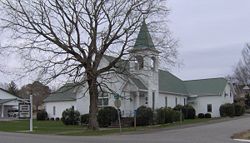
and early settler named Joel Algood, and thus the train stop was named after him. For a period of time the area would be called Algood's Old Fields. In 1899, the Algood Methodist Church (now Algood United Methodist Church) was built on land donated by the children of this early settler. Algood was initially incorporated in 1901, but repealed its own charter two years later. The town reincorporated in 1911.
to the Highland Rim
. Algood is centered along State Route 42 (Main Street) just east of the road's two junctions with State Route 111.
According to the United States Census Bureau
, the town has a total area of 3.8 square miles (9.8 km²), all of it land.
of 2000, there were 2,942 people, 1,181 households, and 792 families residing in the town. The population density
was 766.9 people per square mile (295.8/km²). There were 1,263 housing units at an average density of 329.2 per square mile (127.0/km²). The racial makeup of the town was 93.13% White, 4.93% African American, 0.07% Native American, 0.41% Asian, 0.24% from other races
, and 1.22% from two or more races. Hispanic or Latino of any race were 1.09% of the population.
There were 1,181 households out of which 29.8% had children under the age of 18 living with them, 48.7% were married couples
living together, 14.9% had a female householder with no husband present, and 32.9% were non-families. 30.1% of all households were made up of individuals and 12.4% had someone living alone who was 65 years of age or older. The average household size was 2.35 and the average family size was 2.87.
In the town the population was spread out with 22.6% under the age of 18, 8.7% from 18 to 24, 29.2% from 25 to 44, 20.7% from 45 to 64, and 18.8% who were 65 years of age or older. The median age was 37 years. For every 100 females there were 79.2 males. For every 100 females age 18 and over, there were 74.3 males.
The median income for a household in the town was $27,205, and the median income for a family was $34,234. Males had a median income of $32,443 versus $22,872 for females. The per capita income
for the town was $15,478. About 12.5% of families and 15.5% of the population were below the poverty line, including 19.7% of those under age 18 and 14.0% of those age 65 or over.
Putnam County, Tennessee
Putnam County is a county located in the U.S. state of Tennessee. As of 2000, the population was 62,315, a 21 percent increase from 1990. The was 72,321, an increase of 16.1% since 2000...
, Tennessee
Tennessee
Tennessee is a U.S. state located in the Southeastern United States. It has a population of 6,346,105, making it the nation's 17th-largest state by population, and covers , making it the 36th-largest by total land area...
, United States
United States
The United States of America is a federal constitutional republic comprising fifty states and a federal district...
. The population was 2,942 at the 2000 census. It is part of the Cookeville, Tennessee
Cookeville, Tennessee
Cookeville is a city in Putnam County, Tennessee, United States. The population was 23,923 at the 2000 census. of Cookeville's population was 30,435, and the combined total of those living in Cookeville's in 2010 was 65,014. It is the county seat of Putnam County and home to Tennessee...
Micropolitan Statistical Area
Cookeville micropolitan area
The Cookeville Micropolitan Statistical Area, as defined by the United States Census Bureau, is an area consisting of three counties in central Tennessee, anchored by the city of Cookeville....
.
History
Antebellum architecture
Antebellum architecture is a term used to describe the characteristic neoclassical architectural style of the Southern United States, especially the Old South, from after the birth of the United States in the American Revolution, to the start of the American Civil War...
plantation
Plantation
A plantation is a long artificially established forest, farm or estate, where crops are grown for sale, often in distant markets rather than for local on-site consumption...
and important stopover along the Walton Road (which connected Nashville
Nashville, Tennessee
Nashville is the capital of the U.S. state of Tennessee and the county seat of Davidson County. It is located on the Cumberland River in Davidson County, in the north-central part of the state. The city is a center for the health care, publishing, banking and transportation industries, and is home...
and Knoxville
Knoxville, Tennessee
Founded in 1786, Knoxville is the third-largest city in the U.S. state of Tennessee, U.S.A., behind Memphis and Nashville, and is the county seat of Knox County. It is the largest city in East Tennessee, and the second-largest city in the Appalachia region...
). In the 1880s, the Nashville & Knoxville Railroad erected a depot at what is now Algood. The land on which the depot was built had been purchased from a circuit rider
Circuit rider (Religious)
Circuit rider is a popular term referring to clergy in the earliest years of the United States who were assigned to travel around specific geographic territories to minister to settlers and organize congregations...
and early settler named Joel Algood, and thus the train stop was named after him. For a period of time the area would be called Algood's Old Fields. In 1899, the Algood Methodist Church (now Algood United Methodist Church) was built on land donated by the children of this early settler. Algood was initially incorporated in 1901, but repealed its own charter two years later. The town reincorporated in 1911.
Geography
The town is situated at the base of Algood Mountain (el. 1456 feet (443.8 m)), one of a series of low, wide ridges in the area that present as "stair steps" from the Cumberland PlateauCumberland Plateau
The Cumberland Plateau is the southern part of the Appalachian Plateau. It includes much of eastern Kentucky and western West Virginia, part of Tennessee, and a small portion of northern Alabama and northwest Georgia . The terms "Allegheny Plateau" and the "Cumberland Plateau" both refer to the...
to the Highland Rim
Highland Rim
The Highland Rim is a geographic term for the area in Tennessee surrounding the Central Basin. Nashville is largely surrounded by higher terrain in all directions....
. Algood is centered along State Route 42 (Main Street) just east of the road's two junctions with State Route 111.
According to the United States Census Bureau
United States Census Bureau
The United States Census Bureau is the government agency that is responsible for the United States Census. It also gathers other national demographic and economic data...
, the town has a total area of 3.8 square miles (9.8 km²), all of it land.
Demographics
As of the censusCensus
A census is the procedure of systematically acquiring and recording information about the members of a given population. It is a regularly occurring and official count of a particular population. The term is used mostly in connection with national population and housing censuses; other common...
of 2000, there were 2,942 people, 1,181 households, and 792 families residing in the town. The population density
Population density
Population density is a measurement of population per unit area or unit volume. It is frequently applied to living organisms, and particularly to humans...
was 766.9 people per square mile (295.8/km²). There were 1,263 housing units at an average density of 329.2 per square mile (127.0/km²). The racial makeup of the town was 93.13% White, 4.93% African American, 0.07% Native American, 0.41% Asian, 0.24% from other races
Race (United States Census)
Race and ethnicity in the United States Census, as defined by the Federal Office of Management and Budget and the United States Census Bureau, are self-identification data items in which residents choose the race or races with which they most closely identify, and indicate whether or not they are...
, and 1.22% from two or more races. Hispanic or Latino of any race were 1.09% of the population.
There were 1,181 households out of which 29.8% had children under the age of 18 living with them, 48.7% were married couples
Marriage
Marriage is a social union or legal contract between people that creates kinship. It is an institution in which interpersonal relationships, usually intimate and sexual, are acknowledged in a variety of ways, depending on the culture or subculture in which it is found...
living together, 14.9% had a female householder with no husband present, and 32.9% were non-families. 30.1% of all households were made up of individuals and 12.4% had someone living alone who was 65 years of age or older. The average household size was 2.35 and the average family size was 2.87.
In the town the population was spread out with 22.6% under the age of 18, 8.7% from 18 to 24, 29.2% from 25 to 44, 20.7% from 45 to 64, and 18.8% who were 65 years of age or older. The median age was 37 years. For every 100 females there were 79.2 males. For every 100 females age 18 and over, there were 74.3 males.
The median income for a household in the town was $27,205, and the median income for a family was $34,234. Males had a median income of $32,443 versus $22,872 for females. The per capita income
Per capita income
Per capita income or income per person is a measure of mean income within an economic aggregate, such as a country or city. It is calculated by taking a measure of all sources of income in the aggregate and dividing it by the total population...
for the town was $15,478. About 12.5% of families and 15.5% of the population were below the poverty line, including 19.7% of those under age 18 and 14.0% of those age 65 or over.
External links
- City of Algood — official site
- Algood School
- Algood Branch Library
- Cookeville Gamers