

Algiers Point
Encyclopedia
Algiers Point is a location on the Lower Mississippi River
in New Orleans, Louisiana
. In river pilotage
, Algiers Point is simply one of the many points of land around which the river flows—albeit a significant one. Since the 1970s, the name Algiers Point has also referred to the neighborhood in the immediate vicinity of that point.
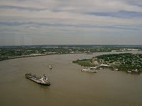 The course of the Mississippi River past and through New Orleans is in the shape of a crescent. As the river reaches the downriver end of that crescent, flowing by then in a northerly direction, it makes a sharp "right-hand" turn to the east. The French Quarter
, Faubourg Marigny
and Bywater
lie on the outside of the bend on the river's left descending bank
. The point of land on the river's right descending bank
is, and has historically been, called Algiers Point.
Just off this point is where the Mississippi River is at its deepest, approximately 60 meters (200 ft) deep. This depth varies from year to year as the river alternately scours and deposits silt
. A U.S. Coast Guard
aid to navigation, Algiers Point Light "95," marks the point. Its geographic coordinates
are 29°57′19"N 90°03′19"W
The U.S. Army
Corps of Engineers
' linear description of the location is mile 94.6 AHP (above Head of Passes
) on the Lower Mississippi River.
In the 20th century, the Coast Guard began regulating marine traffic approaching and rounding Algiers Point. Licensed pilots
were enlisted to man a tower atop the Gov. Nicholls Street Wharf across the river from the point, and to communicate with mariners via marine VHF radio
and via a red and green traffic light, in order to restrict two-way traffic when high water makes such traffic hazardous.
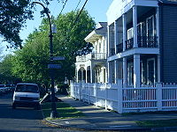 The neighborhood near the point described above came to be called Algiers Point beginning in the 1970s. At that time a community movement began to emphasize the historic and aesthetic aspects of the neighborhood's houses and other assets, as contrasted to other sections of Algiers, especially newer, post-World War II
residential areas.
The size and boundaries of the neighborhood depend on colloquial or legal context, but a conservative description is the approximately 50 city blocks bounded by Opelousas Avenue, Atlantic Avenue and the river. The Algiers Point National Historic District
is bounded on the south by Slidell Avenue instead of Opelousas Avenue. The southern boundary of the city-regulated Algiers Point Historic District, as defined by the New Orleans Historic District Landmarks Commission, is Newton Street.
Some of the houses and other structures in Algiers Point predate the American Civil War
, but most were built in the period immediately after a catastrophic 1895 fire which destroyed hundreds of structures in the area.
Numerous small businesses such as bars, restaurants, coffee shops, and professional services are located here, creating a mixed use neighborhood.
and ProPublica
discovered that white vigilantes in Algiers Point shot African Americans in the days after Katrina. Three police officers have since been convicted in connection with the death of Henry Glover
, who was fatally shot by off-duty police officer David Warren. NOPD officers Dwayne Scheuermann and Greg McRae later stole and set fire to a car containing Mr. Glover's body.
Lower Mississippi River
The Lower Mississippi River is the portion of the Mississippi River downstream of Cairo, Illinois. From the confluence of the Ohio River and Upper Mississippi River at Cairo, the Lower flows just under 1600 kilometers to the Gulf of Mexico...
in New Orleans, Louisiana
Louisiana
Louisiana is a state located in the southern region of the United States of America. Its capital is Baton Rouge and largest city is New Orleans. Louisiana is the only state in the U.S. with political subdivisions termed parishes, which are local governments equivalent to counties...
. In river pilotage
Pilotage
Pilotage is the use of fixed visual references on the ground or sea by means of sight or radar to guide oneself to a destination, sometimes with the help of a map or nautical chart. People use pilotage for activities such as guiding vessels and aircraft, hiking and Scuba diving...
, Algiers Point is simply one of the many points of land around which the river flows—albeit a significant one. Since the 1970s, the name Algiers Point has also referred to the neighborhood in the immediate vicinity of that point.
Navigational point
French Quarter
The French Quarter, also known as Vieux Carré, is the oldest neighborhood in the city of New Orleans. When New Orleans was founded in 1718 by Jean-Baptiste Le Moyne de Bienville, the city was originally centered on the French Quarter, or the Vieux Carré as it was known then...
, Faubourg Marigny
Faubourg Marigny
The Marigny is a neighborhood of the city of New Orleans. A subdistrict of the Bywater District Area, its boundaries as defined by the City Planning Commission are: North Rampart Street and St...
and Bywater
Bywater, New Orleans
Bywater is a neighborhood of the city of New Orleans. A subdistrict of the Bywater District Area, its boundaries as defined by the City Planning Commission are: Florida Avenue to the north, the Industrial Canal to the east, the Mississippi River to the south and Franklin Avenue Street to the west...
lie on the outside of the bend on the river's left descending bank
Left Bank (disambiguation)
In general usage, the left bank of a river normally refers to the left hand bank, as observed whilst facing downstream.Left Bank may refer to:* Left Bank or Rive Gauche, the left or southern bank of the Seine in Paris, France...
. The point of land on the river's right descending bank
Right Bank (disambiguation)
Right Bank may refer to:*Right Bank , the right bank of the Nervión in Biscay, Spain*Right-bank Ukraine, a historical region in Ukraine* Rive Droite, the right or northern bank of the river Seine in Paris, France...
is, and has historically been, called Algiers Point.
Just off this point is where the Mississippi River is at its deepest, approximately 60 meters (200 ft) deep. This depth varies from year to year as the river alternately scours and deposits silt
Silt
Silt is granular material of a size somewhere between sand and clay whose mineral origin is quartz and feldspar. Silt may occur as a soil or as suspended sediment in a surface water body...
. A U.S. Coast Guard
United States Coast Guard
The United States Coast Guard is a branch of the United States Armed Forces and one of the seven U.S. uniformed services. The Coast Guard is a maritime, military, multi-mission service unique among the military branches for having a maritime law enforcement mission and a federal regulatory agency...
aid to navigation, Algiers Point Light "95," marks the point. Its geographic coordinates
Geographic coordinate system
A geographic coordinate system is a coordinate system that enables every location on the Earth to be specified by a set of numbers. The coordinates are often chosen such that one of the numbers represent vertical position, and two or three of the numbers represent horizontal position...
are 29°57′19"N 90°03′19"W
The U.S. Army
United States Army
The United States Army is the main branch of the United States Armed Forces responsible for land-based military operations. It is the largest and oldest established branch of the U.S. military, and is one of seven U.S. uniformed services...
Corps of Engineers
United States Army Corps of Engineers
The United States Army Corps of Engineers is a federal agency and a major Army command made up of some 38,000 civilian and military personnel, making it the world's largest public engineering, design and construction management agency...
' linear description of the location is mile 94.6 AHP (above Head of Passes
Head of Passes
Head of Passes is where the main stem of the Mississippi River branches off into three distinct directions at its mouth in the Gulf of Mexico: Southwest Pass , Pass A Loutre and South Pass...
) on the Lower Mississippi River.
In the 20th century, the Coast Guard began regulating marine traffic approaching and rounding Algiers Point. Licensed pilots
Pilotage
Pilotage is the use of fixed visual references on the ground or sea by means of sight or radar to guide oneself to a destination, sometimes with the help of a map or nautical chart. People use pilotage for activities such as guiding vessels and aircraft, hiking and Scuba diving...
were enlisted to man a tower atop the Gov. Nicholls Street Wharf across the river from the point, and to communicate with mariners via marine VHF radio
Marine VHF radio
Marine VHF radio is installed on all large ships and most seagoing small craft. It is used for a wide variety of purposes, including summoning rescue services and communicating with harbours, locks, bridges and marinas, and operates in the VHF frequency range, between 156 to 174 MHz...
and via a red and green traffic light, in order to restrict two-way traffic when high water makes such traffic hazardous.
Neighborhood
- This is a brief description of a neighborhood within the larger Algiers section of New Orleans.
World War II
World War II, or the Second World War , was a global conflict lasting from 1939 to 1945, involving most of the world's nations—including all of the great powers—eventually forming two opposing military alliances: the Allies and the Axis...
residential areas.
The size and boundaries of the neighborhood depend on colloquial or legal context, but a conservative description is the approximately 50 city blocks bounded by Opelousas Avenue, Atlantic Avenue and the river. The Algiers Point National Historic District
National Register of Historic Places
The National Register of Historic Places is the United States government's official list of districts, sites, buildings, structures, and objects deemed worthy of preservation...
is bounded on the south by Slidell Avenue instead of Opelousas Avenue. The southern boundary of the city-regulated Algiers Point Historic District, as defined by the New Orleans Historic District Landmarks Commission, is Newton Street.
Some of the houses and other structures in Algiers Point predate the American Civil War
American Civil War
The American Civil War was a civil war fought in the United States of America. In response to the election of Abraham Lincoln as President of the United States, 11 southern slave states declared their secession from the United States and formed the Confederate States of America ; the other 25...
, but most were built in the period immediately after a catastrophic 1895 fire which destroyed hundreds of structures in the area.
Numerous small businesses such as bars, restaurants, coffee shops, and professional services are located here, creating a mixed use neighborhood.
Hurricane Katrina shootings
An investigation by The NationThe Nation
The Nation is the oldest continuously published weekly magazine in the United States. The periodical, devoted to politics and culture, is self-described as "the flagship of the left." Founded on July 6, 1865, It is published by The Nation Company, L.P., at 33 Irving Place, New York City.The Nation...
and ProPublica
ProPublica
ProPublica is a non-profit corporation based in New York City. It describes itself as an independent non-profit newsroom that produces investigative journalism in the public interest. In 2010 it became the first online news source to win a Pulitzer Prize, for a piece written by one of its...
discovered that white vigilantes in Algiers Point shot African Americans in the days after Katrina. Three police officers have since been convicted in connection with the death of Henry Glover
Death of Henry Glover
The death of Henry Glover refers to the ongoing controversy over an African American resident of New Orleans, Louisiana, Henry Glover, whose charred body was found in a destroyed Chevrolet Malibu on September 2, 2005, parked on a Mississippi River levee. Five current and former officers of the New...
, who was fatally shot by off-duty police officer David Warren. NOPD officers Dwayne Scheuermann and Greg McRae later stole and set fire to a car containing Mr. Glover's body.
External links
- Algiers Point Association
- Algiers Historical Society
- Algiers Point Information and Links page
- Cita Dennis Hubbell Library
- Southern Pacific Historical & Technical Society
Video
- Story about Algiers Point, from Democracy Now!Democracy Now!Democracy Now! and its staff have received several journalism awards, including the Gracie Award from American Women in Radio & Television; the George Polk Award for its 1998 radio documentary Drilling and Killing: Chevron and Nigeria's Oil Dictatorship, on the Chevron Corporation and the deaths of...
, December 19, 2008