

Alabama State Route 35
Encyclopedia
State Route 35 is a 50 miles (80.5 km) long state route in the northeastern part of the state
. The southern terminus of the route is at its junction with State Route 9
in rural Cherokee County
northeast of Cedar Bluff
and near the Alabama
-Georgia
state line. The northern terminus of the route is at Woodville
in Jackson County
where the route has its second junction with U.S. Highway 72.
as a two-lane road. The route heads in a northwestwardly direction as it passes through the Little River Canyon National Preserve
along the county line dividing Cherokee County and DeKalb County
leading into Fort Payne
. As the highway descends Lookout Mountain within the Fort Payne city limits, it makes a 90-degree right turn at the foot of the mountain. Numerous trucks descending this route have suffered brake failure and wrecked at this turn as a result, causing numerous fatalities. One resident living at this turn, a Joe Faulkner, erected a reinforced concrete wall to protect his property. The wall assumed the popular name, "Joe's Truck Stop."
 From Fort Payne, State Route 35 is routed along a four-lane divided highway as it leads towards Rainsville
. The highway is a four-lane highway from its intersection with U.S. Highway 11 in Fort Payne to its intersection with U.S. Highway 72 in Scottsboro
, except for a brief stretch from near its intersection with Alabama State Route 71
in Section
, to the foot of Sand Mountain
and the east bank of the Tennessee River
, where it intersects Alabama State Route 40
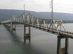
. The Alabama Department of Transportation plans to eventually four-lane this remaining section of the Fort Payne-Scottsboro route. The highway crosses the Tennessee River over the B.B. Comer Bridge (southbound) and the Bob Jones
Bridge (northound). A new bridge is under construction to replace the B.B. Comer Bridge, and is expected to open in 2012. In the early 1990s, a section of the highway was rerouted from a dogleg extending from Fort Payne through Pine Ridge to Rainsville along the natural slope of Sand Mountain, to the current four-lane route. The current route reaches the brow of Sand Mountain along a remarkable manmade ramp that lifts the highway into a manmade gap in the side of the mountain.
Until 1980, the northern terminus of State Route 35 was at Scottsboro, where it intersected U.S. Highway 72. It was extended westward along the former alignment of US-72 after the U.S. Highway was relocated to a new four-lane highway between Scottsboro and Huntsville
. Although SR-35 travels in south by southwestward trajectory as it leaves Scottsboro, it is signed as “North SR-35” until its terminus at a second intersection with US-72 at Woodville
in western Jackson County
.
Alabama
Alabama is a state located in the southeastern region of the United States. It is bordered by Tennessee to the north, Georgia to the east, Florida and the Gulf of Mexico to the south, and Mississippi to the west. Alabama ranks 30th in total land area and ranks second in the size of its inland...
. The southern terminus of the route is at its junction with State Route 9
Alabama State Route 9
State Route 9 is one of the longest state highways in the U.S. state of Alabama. From the Florida state line north to Montgomery, SR-9 is the unsigned partner route of U.S. Highway 331. As a signed route, the southern terminus of SR-9 is at its junction with U.S...
in rural Cherokee County
Cherokee County, Alabama
Cherokee County, Alabama is a county of the U.S. state of Alabama. It is named for the Cherokee tribe. As of 2010 the population was 25,989. Its county seat is Centre and it is a prohibition or dry county.- History :...
northeast of Cedar Bluff
Cedar Bluff, Alabama
Cedar Bluff is a town in Cherokee County, Alabama, United States. At the 2010 census the population was 1,820. NASCAR driver Tina Gordon is from the town. Unlike the rest of the county, Cedar Bluff is a wet city. It is the "Crappie Capital of the World" – it has the highest number of crappie...
and near the Alabama
Alabama
Alabama is a state located in the southeastern region of the United States. It is bordered by Tennessee to the north, Georgia to the east, Florida and the Gulf of Mexico to the south, and Mississippi to the west. Alabama ranks 30th in total land area and ranks second in the size of its inland...
-Georgia
Georgia (U.S. state)
Georgia is a state located in the southeastern United States. It was established in 1732, the last of the original Thirteen Colonies. The state is named after King George II of Great Britain. Georgia was the fourth state to ratify the United States Constitution, on January 2, 1788...
state line. The northern terminus of the route is at Woodville
Woodville, Alabama
Woodville is a town in Jackson County, Alabama, United States, and is included in the Huntsville-Decatur Combined Statistical Area. As of the 2000 census, the population of the town is 761.-History:...
in Jackson County
Jackson County, Alabama
Jackson County is a county of the U.S. state of Alabama. Its name is in honor of Andrew Jackson, general in the United States Army and President of the United States of America. As of 2010, the population was 53,227. The county seat is Scottsboro. Jackson County is a prohibition or dry county,...
where the route has its second junction with U.S. Highway 72.
Route description
North of its origin, State Route 35 begins an ascent over Lookout MountainLookout Mountain
thumb|right|See seven statesLookout Mountain is located at the northwest corner of the U.S. state of Georgia, the northeast corner of Alabama, and along the southern border of Tennessee at Chattanooga. Lookout Mountain, along with Sand Mountain to the northwest, makes up a large portion of the...
as a two-lane road. The route heads in a northwestwardly direction as it passes through the Little River Canyon National Preserve
Little River Canyon National Preserve
Little River Canyon National Preserve is a United States National Preserve located on top of Lookout Mountain near Fort Payne, Alabama, and DeSoto State Park. Created by an act of Congress in 1992, the nearly preserve protects what is sometimes said to be the nation's longest mountaintop river,...
along the county line dividing Cherokee County and DeKalb County
DeKalb County, Alabama
As of the 2010 Census DeKalb County had a population of 71,109. The median age was 37.5. The racial and ethnic makeup of the population was 81.6% non-Hispanic white, 1.5% African American, 1.4% Native American, 0.3% Asian, 0.2% Pacific Islander , 9.9% from some other race, 2.2% reporting two or...
leading into Fort Payne
Fort Payne, Alabama
Fort Payne is a city in DeKalb County, Alabama, United States. At the 2000 census the population was 12,938. The city is the county seat of DeKalb County. It bills itself as the "Official Sock Capital of the World."...
. As the highway descends Lookout Mountain within the Fort Payne city limits, it makes a 90-degree right turn at the foot of the mountain. Numerous trucks descending this route have suffered brake failure and wrecked at this turn as a result, causing numerous fatalities. One resident living at this turn, a Joe Faulkner, erected a reinforced concrete wall to protect his property. The wall assumed the popular name, "Joe's Truck Stop."
Rainsville, Alabama
Rainsville is a city in DeKalb County, Alabama, United States. At the 2000 census the population was 4,499. Rainsville is located on top of Sand Mountain.Rainsville was incorporated in October 1956....
. The highway is a four-lane highway from its intersection with U.S. Highway 11 in Fort Payne to its intersection with U.S. Highway 72 in Scottsboro
Scottsboro, Alabama
Scottsboro is a city in Jackson County, Alabama, United States. As of the 2010 census, the population of the city is 14,770. Named for its founder Robert Scott, the city is the county seat of Jackson County....
, except for a brief stretch from near its intersection with Alabama State Route 71
Alabama State Route 71
State Route 71 is a long route in Jackson County in the northeastern corner of Alabama. The southern terminus of the route is at its junction with State Route 35 near Section...
in Section
Section, Alabama
Section is a township in Jackson County, Alabama, United States and is included in the Huntsville-Decatur Combined Statistical Area. As of the 2000 census, the population of the township is 769. Section is located on top of Sand Mountain. It is also home to the Section Dairy Bar.-Geography:Section...
, to the foot of Sand Mountain
Sand Mountain
Sand Mountain may refer to:* Sand Mountain, a ski resort, in the fictional city of Bikini Bottom* Sand Mountain , the fourth-highest point in Florida* Sand Mountain , a Singing sand dune in Nevada...
and the east bank of the Tennessee River
Tennessee River
The Tennessee River is the largest tributary of the Ohio River. It is approximately 652 miles long and is located in the southeastern United States in the Tennessee Valley. The river was once popularly known as the Cherokee River, among other names...
, where it intersects Alabama State Route 40
Alabama State Route 40
State Route 40 is a long route in the northeastern part of the state. The western terminus of the route is at its junction with State Route 35 near Scottsboro...
. The Alabama Department of Transportation plans to eventually four-lane this remaining section of the Fort Payne-Scottsboro route. The highway crosses the Tennessee River over the B.B. Comer Bridge (southbound) and the Bob Jones
Robert E. Jones, Jr.
Robert E. Jones, Jr. was a member of the United States House of Representatives from the 8th district of Alabama. He was the last to represent that district before it was removed as a result of the 1970 United States Census. Presently there are seven U.S. House districts in Alabama.-Early...
Bridge (northound). A new bridge is under construction to replace the B.B. Comer Bridge, and is expected to open in 2012. In the early 1990s, a section of the highway was rerouted from a dogleg extending from Fort Payne through Pine Ridge to Rainsville along the natural slope of Sand Mountain, to the current four-lane route. The current route reaches the brow of Sand Mountain along a remarkable manmade ramp that lifts the highway into a manmade gap in the side of the mountain.
Until 1980, the northern terminus of State Route 35 was at Scottsboro, where it intersected U.S. Highway 72. It was extended westward along the former alignment of US-72 after the U.S. Highway was relocated to a new four-lane highway between Scottsboro and Huntsville
Huntsville, Alabama
Huntsville is a city located primarily in Madison County in the central part of the far northern region of the U.S. state of Alabama. Huntsville is the county seat of Madison County. The city extends west into neighboring Limestone County. Huntsville's population was 180,105 as of the 2010 Census....
. Although SR-35 travels in south by southwestward trajectory as it leaves Scottsboro, it is signed as “North SR-35” until its terminus at a second intersection with US-72 at Woodville
Woodville, Alabama
Woodville is a town in Jackson County, Alabama, United States, and is included in the Huntsville-Decatur Combined Statistical Area. As of the 2000 census, the population of the town is 761.-History:...
in western Jackson County
Jackson County, Alabama
Jackson County is a county of the U.S. state of Alabama. Its name is in honor of Andrew Jackson, general in the United States Army and President of the United States of America. As of 2010, the population was 53,227. The county seat is Scottsboro. Jackson County is a prohibition or dry county,...
.
Counties traversed
- Cherokee CountyCherokee County, AlabamaCherokee County, Alabama is a county of the U.S. state of Alabama. It is named for the Cherokee tribe. As of 2010 the population was 25,989. Its county seat is Centre and it is a prohibition or dry county.- History :...
- DeKalb CountyDeKalb County, AlabamaAs of the 2010 Census DeKalb County had a population of 71,109. The median age was 37.5. The racial and ethnic makeup of the population was 81.6% non-Hispanic white, 1.5% African American, 1.4% Native American, 0.3% Asian, 0.2% Pacific Islander , 9.9% from some other race, 2.2% reporting two or...
- Jackson CountyJackson County, AlabamaJackson County is a county of the U.S. state of Alabama. Its name is in honor of Andrew Jackson, general in the United States Army and President of the United States of America. As of 2010, the population was 53,227. The county seat is Scottsboro. Jackson County is a prohibition or dry county,...
Major intersections
- State Route 68 at GaylesvilleGaylesville, AlabamaGaylesville is a town in Cherokee County, Alabama, United States. The population was 140 at the 2000 census.Gaylesville was the late 19th & early 20th century home to Isaac Knowles, born in the West Indies...
- State Route 273 at Blanche
- State Route 176State Route 176 (Alabama)State Route 176 was created in September 1980 along previous County/Secondary State Roads 81 and 89 in DeKalb County and part of County/Secondary State Road 89 in Cherokee County...
near Fort PayneFort Payne, AlabamaFort Payne is a city in DeKalb County, Alabama, United States. At the 2000 census the population was 12,938. The city is the county seat of DeKalb County. It bills itself as the "Official Sock Capital of the World."... - U.S. Highway 11 at Fort Payne, where the routes briefly share a wrong-way concurrency
- Interstate 59 at Fort Payne
- State Route 75State Route 75 (Alabama)State Route 75 is a state highway in Alabama that extends northeastward from Birmingham to the Georgia state line. The route runs west of U.S. Highway 11 and roughly parallels that route as well as Interstate 59...
at RainsvilleRainsville, AlabamaRainsville is a city in DeKalb County, Alabama, United States. At the 2000 census the population was 4,499. Rainsville is located on top of Sand Mountain.Rainsville was incorporated in October 1956.... - State Route 71 at SectionSection, AlabamaSection is a township in Jackson County, Alabama, United States and is included in the Huntsville-Decatur Combined Statistical Area. As of the 2000 census, the population of the township is 769. Section is located on top of Sand Mountain. It is also home to the Section Dairy Bar.-Geography:Section...
- State Route 40 south of ScottsboroScottsboro, AlabamaScottsboro is a city in Jackson County, Alabama, United States. As of the 2010 census, the population of the city is 14,770. Named for its founder Robert Scott, the city is the county seat of Jackson County....
- U.S. Highway 72 and State Route 279Alabama State Route 279State Route 279 is a state highway in Jackson County. The southern terminus of the route is at the intersection with State Route 79 south of Scottsboro. The northern terminus is at the intersection with U.S. Highway 72 at Hollywood, just east of Scottsboro. SR-279 is routed along the former...
at Scottsboro - State Route 79State Route 79 (Alabama)State Route 79 is a route that extends northeastward from Birmingham to the Tennessee state line. Prior to the completion of Interstate 65, SR-79 was the southern part of the route that connected Birmingham and Huntsville....
northwest of Scottsboro