
.gif)
A1 (Bosnia and Herzegovina)
Encyclopedia
Bosnia and Herzegovina
Bosnia and Herzegovina , sometimes called Bosnia-Herzegovina or simply Bosnia, is a country in Southern Europe, on the Balkan Peninsula. Bordered by Croatia to the north, west and south, Serbia to the east, and Montenegro to the southeast, Bosnia and Herzegovina is almost landlocked, except for the...
that is part of the Corridor Vc
Corridor Vc
The European route E 73 is a Class-A north-south European route that connects the central part of the continent, specifically Hungary and eastern Croatia to Bosnia and Herzegovina and the Adriatic Sea in the area of the port of Ploče. This route is also designated as the Pan-European Corridor...
and, together with two Croatian motorways (A10
A10 (Croatia)
The A10 motorway is a planned motorway, expected to be built in southern Croatia between the border of Bosnia and Herzegovina, extending from the Bosnia and Herzegovina A1 motorway towards the Croatian A1 motorway Metković interchange. The motorway is planned to include the Metković border...
and A5)
A5 (Croatia)
The A5 motorway is a motorway in Croatia spanning . It connects Osijek, the largest city in Slavonia region, to the Croatian motorway network at the Sredanci interchange of the A3 motorway. The A5 represents a significant north–south transportation corridor in Croatia and is a part of the...
and the Hungarian M6
M6 motorway (Hungary)
The M6 motorway is a north-south motorway in Hungary running along the Danube connecting Budapest to the seat of Baranya county Pécs, and further south to the Croatian border.Construction progress:...
, will provide a modern and fast road connection from Budapest
Budapest
Budapest is the capital of Hungary. As the largest city of Hungary, it is the country's principal political, cultural, commercial, industrial, and transportation centre. In 2011, Budapest had 1,733,685 inhabitants, down from its 1989 peak of 2,113,645 due to suburbanization. The Budapest Commuter...
to Ploče
Ploce
Ploče is a town and a notable seaport in the Dubrovnik-Neretva County of Croatia.The total population of Ploče is 10,102 , in the following settlements:* Baćina, population 564* Banja, population 176* Komin, population 1,222...
, an important seaport on the Adriatic Sea
Adriatic Sea
The Adriatic Sea is a body of water separating the Italian Peninsula from the Balkan peninsula, and the system of the Apennine Mountains from that of the Dinaric Alps and adjacent ranges...
.
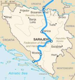
The motorway will connect the capital Sarajevo
Sarajevo
Sarajevo |Bosnia]], surrounded by the Dinaric Alps and situated along the Miljacka River in the heart of Southeastern Europe and the Balkans....
with important cities (such as Mostar
Mostar
Mostar is a city and municipality in Bosnia and Herzegovina, the largest and one of the most important cities in the Herzegovina region and the center of the Herzegovina-Neretva Canton of the Federation. Mostar is situated on the Neretva river and is the fifth-largest city in the country...
and Zenica
Zenica
Zenica is an industrial city in Bosnia and Herzegovina. It is the capital of the Zenica-Doboj Canton of the Federation of Bosnia and Herzegovina entity...
); it will also be the main way to reach Bosnia and Herzegovina, both from the sea and Central Europe.
By 2009, the only section already built stretches from Sarajevo to Kakanj, while the section continuing to Zenica is currently under construction.
Short-term projects include the section between Dobrinje and Zenica, as well as the connection with future Sarajevo bypass.
The hardest section to project and build will be the Sarajevo-Mostar, which will need viaducts and tunnels in order to cross the Dinaric Alps
Dinaric Alps
The Dinaric Alps or Dinarides form a mountain chain in Southern Europe, spanning areas of Slovenia, Croatia, Bosnia and Herzegovina, Serbia, Kosovo, Albania and Montenegro....
.
There is one toll barrier in Josanica (2.00 KM).
In Bosnia and Herzegovina the E73/A1 passes near the following cities:
- Bosanski Šamac
- Bosanski BrodBosanski BrodBrod also known as Bosanski Brod is a town and municipality located on the south bank of the river Sava in the northern part of Bosnia and Herzegovina. It is situated in the north-western part of the Republika Srpska and the western part of the Posavina region.-Name:Prior to the Bosnian War it...
- ModričaModricaModriča is a city and municipality in Bosnia and Herzegovina, in Republika Srpska entity. It is located near the towns of Šamac, Derventa and Doboj...
- DobojDobojDoboj is a city and a municipality in northern Bosnia and Herzegovina, situated in the northern part of the Republika Srpska entity on the river Bosna. Doboj is the largest national railway junction; as such, the seats of the Republika Srpska Railways, and the Railways Corporation of Bosnia and...
- ZenicaZenicaZenica is an industrial city in Bosnia and Herzegovina. It is the capital of the Zenica-Doboj Canton of the Federation of Bosnia and Herzegovina entity...
- KakanjKakanjKakanj , is an industrial town and a municipality in central Bosnia and Herzegovina, located north of Visoko and southeast of Zenica. It was built along the slopes of wide hills on either side of the Zgošća river...
- VisokoVisokoVisoko is a city and municipality in central Bosnia and Herzegovina of rich historical heritage. It was an early centre of the Bosnian medieval state, and the site where the first Bosnian king Tvrtko I was crowned. Located between Zenica and Sarajevo, Visoko lies on the Bosna river where the...
- SarajevoSarajevoSarajevo |Bosnia]], surrounded by the Dinaric Alps and situated along the Miljacka River in the heart of Southeastern Europe and the Balkans....
- KonjicKonjicKonjic is a town and municipality in Bosnia and Herzegovina. It is located in northern Herzegovina, around southwest of Sarajevo. It is a mountainous, heavily wooded area, and is above sea level. The municipality extends on both sides of the Neretva River. The town of Konjic, housed about a third...
- JablanicaJablanica, Bosnia and HerzegovinaJablanica is a town and municipality of the same name in central Bosnia and Herzegovina. The town is situated on the Neretva river and Jablanica lake. Jablanica is a part of the Herzegovina-Neretva Canton.-Geography:...
- MostarMostarMostar is a city and municipality in Bosnia and Herzegovina, the largest and one of the most important cities in the Herzegovina region and the center of the Herzegovina-Neretva Canton of the Federation. Mostar is situated on the Neretva river and is the fifth-largest city in the country...
Significance
In Bosnia and Herzegovina, the Corridor Vc highway is one of the most significant and project of the highest priority. The construction works on the road have already begun, but intensified beginning of the construction will be a key starter of economic and social activities, and will enable Bosnia and Herzegovina to be connected to main European traffic network, as well as to global European economic and social structure.Construction of the highway, whose total length is 340 km, will provide: rational connecting to neighboring countries and regions; stabilizing and developing effects will be reached; transport conditions and quality of life improvement; economy competitiveness enhancement; new projects launched and national and international private investments enhancement
The transport Corridor Vc through Bosnia and Herzegovina includes:
- E-road E 73 Šamac-Doboj-Sarajevo-Mostar-Čapljina-Doljani, with exit to the Adriatic Sea in the Port of PločePort of PločeThe Port of Ploče is a seaport in Ploče, Croatia, near the mouth of the Neretva river on the Adriatic Sea coast. It was formally opened in 1945 after a railway was built as a a supply route to connect the site with industrial facilities in the Sarajevo and Mostar areas of Bosnia and Herzegovina,...
. - The railway Šamac-Doboj-Sarajevo-Mostar-Čapljina-Metković.
- Sarajevo and Mostar Airports.
- Waterways and quays on the Sava, Bosna and Neretva Rivers.
Transport Master Plan
Japanese International Cooperation Agency (JICA) funded provision of Transport Master Plan for Bosnia and Herzegovina (March 2001), which represents the first document in afterwar period at this level in transport area, and it was used as basis for many other studies and decisions, even for provision of Planning and Study Documentation for the Highway along the Corridor Vc.This Study provided priority transport corridors in Bosnia and Herzegovina, which were afterwards confirmed by subsequent studies, to a great extent.
At the same time, this Study defined main goals in transport sector in Bosnia and Herzegovina, as well as Development Scenario by 2020. Development Scenario includes three phases:
- Phase 1 (short-term): 2000-2005 – Rehabilitation & Stabilization
- Phase 2 (medium-term): 2006-2010 – Full functionalization & Modernization
- Phase 3 (long-term): 2011-2020 – Structuring & Progress
Sections
Length of the Corridor Vc highway, from the North to the South divided by sections:- Section 1: The Sava Svilaja River (connection Corridor X) - Doboj (South)
- 64 km
- Section 2: Doboj (South) - Sarajevo South (Tarčin)
- 150 km
- Section 3: Sarajevo South (Tarčin) - Mostar (North)
- 58 km
- Section 4: Mostar (North) - Republic of Croatia Border
- 68 km
- Total: 340 km
- 68 km