
2008 Morpeth Flood
Encyclopedia
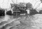
The 2008 Morpeth Flood occurred on Saturday, 6 September 2008. It was caused by heavy sustained rainfall in the preceding 24 hours. The River Wansbeck
burst its banks and inundated the town’s flood defences around 1500 BST, causing damage to 995 properties, 906 of which were residential.
 Previous flooding events occurred in 1863, 1876, 1877, 1878, 1881, 1886, 1898, 1900, 1903, 1924, 1963 and 1968 (Cotting Burn).
The last major flood to affect Morpeth took place on 7 March 1963. Unlike the 2008 flood, the primary cause was rapid thawing of snow and ice in the town and Wansbeck valley. The winter of 1962/3 was particularly harsh and snow had built up to over 3ft in the upper valley areas. All this snow thawed in a 48 hour period, overwhelming the River Wansbeck drainage basin
system. 482 homes and 21 businesses were damaged by the ensuing surge. In the aftermath a relief fund was set up, raising £16,000 that was paid out to 350 claims. An estimated £50,000 of losses was suffered by businesses and the local authority.
Following the 1963 flood, a flood defence scheme was established. Flood walls were erected on the north bank to protect the main business district. Housing properties at Middle Greens on the south bank were also protected by flood walls.
In 1992, a record peak water level of 3.19 metres (10.5 ft) was recorded in the river channel. The 2008 flood level was 0.8 metres higher than this. However, there was not a flood event in 1992 as the defences successfully protected the town centre.
recorded 150 millimetres (5.9 in) of precipitation
falling in the Wansbeck catchment between Friday 5 September and Saturday 6 September. Figures suggest that in Morpeth alone there was 86 millimetres (3.4 in) of rain compared to an average of 74 millimetres (2.9 in) for a month. Environment Agency statistics show that it was a unique event as peak river discharge was the highest that had ever been recorded.
. Based on three storm events, a reliable flow gauge located upstream of Morpeth at the confluence
of the Wansbeck and Font showed that 56% of rain fall is converted into surface runoff. Because the soil was already saturated as a result of the wet summer, the effect of surface runoff was greatly enhanced. Furthermore, increased urbanisation since the 1960s in Morpeth meant that most water falling on the town would have drained directly to the river channel. Other tests investigating the catchment lag time (time lapse between the mid point of storm rainfall and peak river level) indicate that the Wansbeck has a LAG time of only 8 hours. This means that any water falling in the catchment area
would have been rapidly converted into channel flow by surface runoff and to a lesser extent by throughflow
. This is due to the steepness of the valley and the soil composition.

 On Monday 8 September 2008, John Healey
, Floods Recovery Minister visited Morpeth. Official Government aid was pledged to the local authority to help with costs of the disaster through the Bellwin Scheme. Mr Healey was also in talks with insurance industry chiefs, discussing their plans for dealing with a large number of claims in affected areas as quickly and effectively as possible.
Furthermore, discussions with the Environment Agency to bring forward proposals for new flood defences took place. An Environment Agency report of December 2007 suggested improvements are needed to the town flood walls. Oldgate Bridge may need some structural changes made as it has a damming effect during flood events. An upstream reservoir to hold back flood water was also proposed. If successful, improvements could be made by 2011.
Morpeth Lions Club aims to raise £100,000 which could be paid out to those without insurance.
HRH Prince Charles of Wales and Camilla, Duchess of Cornwall made an official visit on Friday 12 September. During their visit they inspected the damage and spoke with victims of the flood.
River Wansbeck
The River Wansbeck runs through the county of Northumberland, England. It rises above Sweethope Lough on the edge of Forelaws Forest in the area known locally as The Wanneys ; runs through the town of Ashington before discharging into the North Sea at Sandy Bay near Newbiggin-by-the-Sea.The River...
burst its banks and inundated the town’s flood defences around 1500 BST, causing damage to 995 properties, 906 of which were residential.
Background
The last major flood to affect Morpeth took place on 7 March 1963. Unlike the 2008 flood, the primary cause was rapid thawing of snow and ice in the town and Wansbeck valley. The winter of 1962/3 was particularly harsh and snow had built up to over 3ft in the upper valley areas. All this snow thawed in a 48 hour period, overwhelming the River Wansbeck drainage basin
Drainage basin
A drainage basin is an extent or an area of land where surface water from rain and melting snow or ice converges to a single point, usually the exit of the basin, where the waters join another waterbody, such as a river, lake, reservoir, estuary, wetland, sea, or ocean...
system. 482 homes and 21 businesses were damaged by the ensuing surge. In the aftermath a relief fund was set up, raising £16,000 that was paid out to 350 claims. An estimated £50,000 of losses was suffered by businesses and the local authority.
Following the 1963 flood, a flood defence scheme was established. Flood walls were erected on the north bank to protect the main business district. Housing properties at Middle Greens on the south bank were also protected by flood walls.
In 1992, a record peak water level of 3.19 metres (10.5 ft) was recorded in the river channel. The 2008 flood level was 0.8 metres higher than this. However, there was not a flood event in 1992 as the defences successfully protected the town centre.
Causes
The Environment AgencyEnvironment Agency
The Environment Agency is a British non-departmental public body of the Department for Environment, Food and Rural Affairs and an Assembly Government Sponsored Body of the Welsh Assembly Government that serves England and Wales.-Purpose:...
recorded 150 millimetres (5.9 in) of precipitation
Precipitation (meteorology)
In meteorology, precipitation In meteorology, precipitation In meteorology, precipitation (also known as one of the classes of hydrometeors, which are atmospheric water phenomena is any product of the condensation of atmospheric water vapor that falls under gravity. The main forms of precipitation...
falling in the Wansbeck catchment between Friday 5 September and Saturday 6 September. Figures suggest that in Morpeth alone there was 86 millimetres (3.4 in) of rain compared to an average of 74 millimetres (2.9 in) for a month. Environment Agency statistics show that it was a unique event as peak river discharge was the highest that had ever been recorded.
Physical
The River Wansbeck Valley is narrow and steep and as a consequence has exaggerated amounts of surface runoffSurface runoff
Surface runoff is the water flow that occurs when soil is infiltrated to full capacity and excess water from rain, meltwater, or other sources flows over the land. This is a major component of the water cycle. Runoff that occurs on surfaces before reaching a channel is also called a nonpoint source...
. Based on three storm events, a reliable flow gauge located upstream of Morpeth at the confluence
Confluence
Confluence, in geography, describes the meeting of two or more bodies of water.Confluence may also refer to:* Confluence , a property of term rewriting systems...
of the Wansbeck and Font showed that 56% of rain fall is converted into surface runoff. Because the soil was already saturated as a result of the wet summer, the effect of surface runoff was greatly enhanced. Furthermore, increased urbanisation since the 1960s in Morpeth meant that most water falling on the town would have drained directly to the river channel. Other tests investigating the catchment lag time (time lapse between the mid point of storm rainfall and peak river level) indicate that the Wansbeck has a LAG time of only 8 hours. This means that any water falling in the catchment area
Drainage basin
A drainage basin is an extent or an area of land where surface water from rain and melting snow or ice converges to a single point, usually the exit of the basin, where the waters join another waterbody, such as a river, lake, reservoir, estuary, wetland, sea, or ocean...
would have been rapidly converted into channel flow by surface runoff and to a lesser extent by throughflow
Throughflow
In hydrology, throughflow is the horizontal movement of water in the soil zone. This type of flow must first emerge on land before it enters a body of surface water to be considered throughflow...
. This is due to the steepness of the valley and the soil composition.
Effects
Social
During 6 September 2008, more than 400 residents were evacuated. Shelter was provided in the Town Hall, King Edward VI High School and County Hall. An error made by the Environment Agency's warning system meant that 198 properties in the Middle Greens area of the town did not receive a flood warning. Fire fighters, ambulance crews, the RAF, the RNLI and the British Red Cross were among the emergency services involved in rescue and recovery operations over the weekend. Many residents had to be forced from their homes, and lived in caravans or with relatives as rebuilding took place.Economic
995 properties in Morpeth town centre were directly affected by the flood water. Among the businesses in the town centre, Smails and Sons, a shop that has been a cornerstone of the Morpeth community for over 60 years, was left completely out of stock. Early estimates suggest that damages could be over £10 million. However, the actual figure was much greater, with total losses estimated at £40 million. On Sunday 7 September, Morpeth Lions Club and the Red Cross launched the Morpeth Flood Disaster Fund and by Wednesday 10 September had raised over £20,000.Environmental
At the peak of the flood, Morpeth High Street (Bridge Street) was under 60 centimetres (2 ft) of water. Not since 1963 had the main street been flooded. The library suffered severe structural damage due to the heavy debris transported by the river. Such was the extent of the damage that structural engineers were required to test its safety.Aftermath and solutions
John Healey
John Healey is a British Labour Party politician, who has been the Member of Parliament for Wentworth and Dearne since 1997, and former Minister of State for Housing and Planning. In 2010 he was elected to the shadow cabinet and appointed shadow health secretary...
, Floods Recovery Minister visited Morpeth. Official Government aid was pledged to the local authority to help with costs of the disaster through the Bellwin Scheme. Mr Healey was also in talks with insurance industry chiefs, discussing their plans for dealing with a large number of claims in affected areas as quickly and effectively as possible.
Furthermore, discussions with the Environment Agency to bring forward proposals for new flood defences took place. An Environment Agency report of December 2007 suggested improvements are needed to the town flood walls. Oldgate Bridge may need some structural changes made as it has a damming effect during flood events. An upstream reservoir to hold back flood water was also proposed. If successful, improvements could be made by 2011.
Morpeth Lions Club aims to raise £100,000 which could be paid out to those without insurance.
HRH Prince Charles of Wales and Camilla, Duchess of Cornwall made an official visit on Friday 12 September. During their visit they inspected the damage and spoke with victims of the flood.
External links
- The Morpeth Flood project (Geoff Parkin, Newcastle University, School of Civil Engineering and Geosciences)
- morpeth flood videos
- morpeth herald photos today flood photos