
2005 Maharashtra floods
Overview
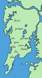
The 2005 Maharashtra floods refers to the flooding of many parts of the Indian state of Maharashtra
Maharashtra
Maharashtra is a state located in India. It is the second most populous after Uttar Pradesh and third largest state by area in India...
including large areas of the metropolis Mumbai
Mumbai
Mumbai , formerly known as Bombay in English, is the capital of the Indian state of Maharashtra. It is the most populous city in India, and the fourth most populous city in the world, with a total metropolitan area population of approximately 20.5 million...
, a city located on the coast of the Arabian Sea
Arabian Sea
The Arabian Sea is a region of the Indian Ocean bounded on the east by India, on the north by Pakistan and Iran, on the west by the Arabian Peninsula, on the south, approximately, by a line between Cape Guardafui in northeastern Somalia and Kanyakumari in India...
, on the western coast of India
India
India , officially the Republic of India , is a country in South Asia. It is the seventh-largest country by geographical area, the second-most populous country with over 1.2 billion people, and the most populous democracy in the world...
, in which at least 5,000 people died. It occurred just one month after the June 2005 Gujarat floods
2005 Gujarat Flood
The 2005 Gujarat Flood was a bout of major flooding affecting many parts of Gujarat and was caused by heavy monsoon rains in June 2005.Many of the southern districts of Gujarat were on flood alert. Rivers in the Valsad district were well above the flood level...
. The term 26 July, now is, in context always used for the day when the city of Mumbai came to a standstill.
Large numbers of people were stranded on the road, lost their homes, and many walked for long distances back home from work that evening.
Unanswered Questions