
1990-1995 Southern Hemisphere tropical cyclone seasons
Encyclopedia
The 1990–1995 Southern Hemisphere tropical cyclone seasons ran year-round from 1 July to 30 June during each year between 1990 and 1995. Tropical cyclone
activity in the Southern Hemisphere
reaches its peak from mid-February to early March.
1980–85 1985–90 1990–95 1995–96 1996–97
Tropical cyclone
A tropical cyclone is a storm system characterized by a large low-pressure center and numerous thunderstorms that produce strong winds and heavy rain. Tropical cyclones strengthen when water evaporated from the ocean is released as the saturated air rises, resulting in condensation of water vapor...
activity in the Southern Hemisphere
Southern Hemisphere
The Southern Hemisphere is the part of Earth that lies south of the equator. The word hemisphere literally means 'half ball' or "half sphere"...
reaches its peak from mid-February to early March.
1980–85 1985–90 1990–95 1995–96 1996–97
1990–91 Southern Hemisphere tropical cyclone season
1991–92 Southern Hemisphere tropical cyclone season
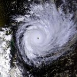
Tropical Cyclone Fran
While out at sea, Fran reached the powerful Category 5 equivalent on the Saffir–Simpson Hurricane Scale. Eventually, as a Category 2 system, Fran crossed the coast near 1770, Queensland1770, Queensland
1770 is a village in Queensland, Australia, built on the site of the second landing by James Cook and the crew of HM Bark Endeavour in May 1770 . Originally known as Round Hill — after the creek it sits on — the name was changed in 1970 to commemorate the bicentennial of Cook's visit...
on 16 March 1992. Having crossed the coast a first time, Fran turned to the south-east and crossed the coast again, at Fraser Island, before heading back out to sea. The cyclone damaged houses in Bundaberg and extensively damaged a marina complex at Burnett Heads
Burnett Heads, Queensland
Burnett Heads is a town at the mouth of the Burnett River in Queensland, Australia, located 16 km north of the regional city of Bundaberg. At the 2006 census, Burnett Heads had a population of 2,419....
. The Kolan and Burnett rivers suffered major flooding. No deaths were attributed to this cyclone.
Severe Tropical Cyclone Ian
Naomi was the first cyclone of the 1993/94 season. Forming early on 15 December 1993, the storm moved south and strengthened into a Category 3 before making landfall. There was moderate damage and a fishing boat was disabled during the storm. There were no deaths.Tropical Cyclone Oscar
Cyclone Oscar was a weak system, and only barely reached cyclone strength on 3 January 1994 for about a 12 hour period. It moved on a generally westsouthwest course parallel to the KimberleyKimberley region of Western Australia
The Kimberley is one of the nine regions of Western Australia. It is located in the northern part of Western Australia, bordered on the west by the Indian Ocean, on the north by the Timor Sea, on the south by the Great Sandy and Tanami Deserts, and on the east by the Northern Territory.The region...
and Pilbara coasts. http://www.bom.gov.au/weather/wa/cyclone/about/seasonsummary199394.shtml
Tropical Cyclone Pearl
Tropical Cyclone Pearl developed off the northwest KimberleyKimberley region of Western Australia
The Kimberley is one of the nine regions of Western Australia. It is located in the northern part of Western Australia, bordered on the west by the Indian Ocean, on the north by the Timor Sea, on the south by the Great Sandy and Tanami Deserts, and on the east by the Northern Territory.The region...
coast on 11 January 1994 and moved westwards as a very small but severe Category 3 cyclone covering a distance of more than 4000 km, before finally dissipating in the Central Indian Ocean on the 22nd. http://www.bom.gov.au/weather/wa/cyclone/about/seasonsummary199394.shtml
Tropical Cyclone Quenton
Tropical Cyclone Quenton began as a tropical low to the east of Christmas IslandChristmas Island
The Territory of Christmas Island is a territory of Australia in the Indian Ocean. It is located northwest of the Western Australian city of Perth, south of the Indonesian capital, Jakarta, and ENE of the Cocos Islands....
on 23 January 1994. The low moved slowly west, then on 25 January intensified to cyclone strength and moved southward across the Indian Ocean. By early on the 27th the cyclone had dissipated. http://www.bom.gov.au/weather/wa/cyclone/about/seasonsummary199394.shtml
Tropical Cyclone Sharon
Tropical Cyclone Sharon was the most intense cyclone in the Western Australian region during the 1993/94 season. It formed about 1100 km north of Northwest Cape on 13 March 1994, then rapidly intensified during the 14th while moving on a southsouthwest path towards the west Pilbara coast. During the 16th the cyclone rapidly weakened due to movement into a region of strong westerly wind shear. Cyclone warnings were issued for the west Pilbara and upper west coast on the 16th but were cancelled on the morning of the 17th Continued shearing and subsequent movement over cooler waters weakened the storm to below cyclone strength by the morning of the 18th. http://www.bom.gov.au/weather/wa/cyclone/about/seasonsummary199394.shtmlTropical Cyclone Tim
Tropical Cyclone Tim was a very small weak system that moved on a generally westward path from south of Sumatra to the Cocos Islands from 30 March to 1 April 1994. It passed about 100 km to the south of Christmas IslandChristmas Island
The Territory of Christmas Island is a territory of Australia in the Indian Ocean. It is located northwest of the Western Australian city of Perth, south of the Indonesian capital, Jakarta, and ENE of the Cocos Islands....
but its effects, other than a wind shift, were barely recognisable on the Island. http://www.bom.gov.au/weather/wa/cyclone/about/seasonsummary199394.shtml
Tropical Cyclone Vivienne
Tropical Cyclone Vivienne formed from a tropical low that had moved westward across the Timor Sea. It intensified rapidly during the afternoon and night of 7 April 1994, reaching maximum intensity on 8 April when it was located 550 km to the northnorthwest of Broome. Its development from here on was hampered by vertical wind shear and Vivienne moved on a generally westsouthwest path parallel to, but well offshore from, the Western Australian coastline. It dissipated on 11 April and no watches or warnings were issued. http://www.bom.gov.au/weather/wa/cyclone/about/seasonsummary199394.shtmlTropical Cyclone Willy
Willy was a Category 1 cyclone lasting from 28 to 30 April 1994 that passed about 80 km west of the Cocos Islands. http://www.bom.gov.au/weather/wa/cyclone/about/seasonsummary199394.shtmlTropical Cyclone Rewa
Cyclone Rewa formed on 26 December 1993. It looped around the Coral Sea for almost a month, crossed New Caledonia and the Solomon Island, and dissipated on 21 January. Rewa was the longest-lived South Pacific tropical cyclone on record, lasting 25 days, from 26 December to 21 January.Intense Tropical Cyclone Geralda
Part of a spree of four powerful cyclones to impact Madagascar this year, Geralda killed 200 people and left half a million homeless as it made landfall on the island in early February.Tropical Cyclone Hollanda
Named shortly after Geralda was dissipating, Hollanda, a category 4 cyclone was the most devastating tropical cyclone to have hit the island of MauritiusMauritius
Mauritius , officially the Republic of Mauritius is an island nation off the southeast coast of the African continent in the southwest Indian Ocean, about east of Madagascar...
in the Indian Ocean since tropical cyclone Gervaise in 1975. The cyclone passed 10 km to the west of Mauritius on February 10, 1994. The island was seriously affected, with winds of over 160 km/h (100 mph) and torrential rains (an average of 400mm for the island). The maximum gusts speed recorded was 218 km/h when Hollanda was at its closest to the country, earning a warning cyclone class 4 (the maximum). A warning cyclone class 4 is issued by the Mauritian Meteorological Services when gusts speeds of the order of 120 km/h is being recorded on the island and is expected to continue. On the Saffir–Simpson Hurricane Scale, Hollanda reached category 4 (winds speeds of 210–249 km/h). Some sources issued that tropical cyclone Hollanda could have exceeded the gusts speed of 216 km/h and reached about 300 km/h in Port Louis
Port Louis
-Economy:The economy is dominated by its port, which handles Mauritius' international trade. The port was founded by the French who preferred Port Louis as the City is shielded by the Port Louis/Moka mountain range. It is the largest container handling facility in the Indian Ocean and can...
due to the considerable damage caused in the northern part of the island. In the capital city, some concrete buildings were severely damaged and a construction tower crane collapsed. The Mauritius Meteorological Services rejected that Hollanda could have peak to a category 5 or a very intense tropical cyclone with gusts of 280–300 km/h. During the cyclone, three people died by a falling tree, 50% of the telephone system was down, electrical power was nearly completely out, 50% of sugar plantation was destroyed, many vegetables fields were devastated, 1500 people became homeless and concrete buildings were moderately damaged. Major roads were blocked by trees and landslides. The estimated damaged caused by the cyclone was USD 135.4 million.http://reliefweb.int/rw/RWB.NSF/db900SID/ACOS-64DC4U?OpenDocumenthttp://www.cyclonextreme.com/cyclonereunionsystsaison94Hollanda.htmhttp://pedagogie2.ac-reunion.fr/cotamarp/temps/cyclone/historique/hollandagroupe5.htm
Tropical Cyclone Nadia
The last of the spree of devastating Madagascar cyclones, Nadia made landfall in Madagascar in late March. After crossing the northern tip of the island, Nadia impacted Mozambique before returning to the Mozambique channel and finally dissipating. Nadia killed dozens in Madagascar. It claimed around 200 more lives in Mozambique and left over one million people homeless.Tropical Depression 29P
On April 20, the JTWC started to monitor an area of low pressure that located over the Solomon Islands about 155 km (96.3 mi) to the north of HoniaraHoniara
Honiara, population 49,107 , 78,190 , is the capital of the Solomon Islands and of Guadalcanal Province, although it is a separately administered town...
. During that day the disturbance moved towards the southeast and passed over several of the Solomon Islands, before emerging into the Australian basin. Over the next couple of days the disturbance gradually developed further while moving towards the southwest before re-curving and moving southeastwards. On April 24, as it moved back into the South Pacific basin, the JTWC initiated advisories on the disturbance, designating it as Tropical Cyclone 29P, with peak windspeeds equivalent to a tropical depression. As the system was classified, it recurved again and started to move slowly towards the northwest, and started to feel the effects of a hgih amount of vertical windshear. As a result of the windshear, the center became exposed and displaced from the deep convection before the JTWC issued their final advisory on April 25 as 29P weakened into an area of low pressure, before dissipating later that day about 600 km (372.8 mi) to the southwest of Honiara.
1994–95 Southern Hemisphere tropical cyclone season
Tropical Cyclone Annette
Annette formed on 15 December 1994. The storm moved southeastward while intensifying to a Category 4 cyclone. Annette made landfall at Mandora StationMandora Station
Mandora Station is a cattle station on the Western Australia coast south of Broome, located in the Shire of Broome. It maintains a weather station and is noted for the Mandora Marsh wetland, and for its proximity to Eighty Mile Beach, which are key stopping places for migratory birds.Mandora...
on 18 December. There was considerable damage to homes and crops and about a 1,000 cattle were lost in the storm.http://www.bom.gov.au/weather/wa/cyclone/about/seasonsummary199495.shtml
Tropical Cyclone Bobby
Severe Tropical Cyclone Bobby, a Category 4 cyclone with estimated winds up to 270 km/hour near the centre, crossed the Western Australian Pilbara coast to the east of OnslowOnslow, Western Australia
Onslow is a coastal town in the Pilbara region of Western Australia, north of Perth. It currently has a population of around 573 people and is in the Shire of Ashburton Local Government Area....
between midnight and 0100 on the 25 February 1995. Seven lives were lost when two fishing trawlers were sunk off the coast from Onslow. A bulk ore carrier also ran aground in the cyclone. There was very minor property damage reported from the Karratha area and approximately 20 houses in Onslow suffered superficial roofing damage. Cyclone Bobby also brought heavy rains and extensive flooding to the south of the Pilbara area, which damaged roads, bridges and crops and seriously affected mining production. A motorist was drowned inland from Carnarvon
Carnarvon, Western Australia
Carnarvon is a coastal town situated approximately 900 kilometres north of Perth, Western Australia. It lies at the mouth of the Gascoyne River on the Indian Ocean. The popular Shark Bay world heritage area lies to the south of the town and the Ningaloo Reef lies to the north...
while attempting to cross a flooded creek.
Tropical Cyclone Chloe
The third major cyclone to strike Australia. Cyclone Chloe reached Category 5 status before making landfall in the uninhabited section of the coast of the Kimberley region of Western Australia on 7 April 1995. The storm dissipated well inland.http://www.bom.gov.au/weather/wa/cyclone/about/seasonsummary199495.shtmlOther tropical cyclones
The following tropical cyclones also occurred within the 1994–1995 Southern Hemisphere tropical cyclone season: http://www.usno.navy.mil/NOOC/nmfc-ph/RSS/jtwc/atcr/1995atcr/pdf/chapter4.pdf- Violet, 3 to 7 March 1995, Category 3 in Pacific Ocean
- Warren, 5 to 6 March 1995, Gulf of Carpentaria
- Agnes, 17 to 22 April 1995, Category 3 near Cape York, Queensland
See also
- Tropical cycloneTropical cycloneA tropical cyclone is a storm system characterized by a large low-pressure center and numerous thunderstorms that produce strong winds and heavy rain. Tropical cyclones strengthen when water evaporated from the ocean is released as the saturated air rises, resulting in condensation of water vapor...
- List of Southern Hemisphere tropical cyclone seasons