
1974 Pacific hurricane season
Encyclopedia
Tropical cyclone
A tropical cyclone is a storm system characterized by a large low-pressure center and numerous thunderstorms that produce strong winds and heavy rain. Tropical cyclones strengthen when water evaporated from the ocean is released as the saturated air rises, resulting in condensation of water vapor...
s form in the northeast Pacific Ocean
Pacific Ocean
The Pacific Ocean is the largest of the Earth's oceanic divisions. It extends from the Arctic in the north to the Southern Ocean in the south, bounded by Asia and Australia in the west, and the Americas in the east.At 165.2 million square kilometres in area, this largest division of the World...
.
With seventeen storms, this season was slightly above average. At eleven, the number of hurricanes was also above average. In the central Pacific, one tropical storm formed. Very unusually, on August 26 there were six systems active: Ione, Olive, Kirsten, Lorraine, Joyce, and Maggie. Olive was a Central Pacific storm and had weakened to a tropical depression by this time. The other five were of at least tropical storm intensity simultaneously and remained so until 06Z Aug 27. Five storms were also active 18Z Aug 23-06Z Aug 24.
Season summary
The overall activity of the 1974 season was near normal, with 25 tropical cycloneTropical cyclone
A tropical cyclone is a storm system characterized by a large low-pressure center and numerous thunderstorms that produce strong winds and heavy rain. Tropical cyclones strengthen when water evaporated from the ocean is released as the saturated air rises, resulting in condensation of water vapor...
s developing. Of these storms, 18 were named, 11 became hurricanes and 4 reached major hurricane status. Although the overall number of storms was normal, an exceptionally active period took place on August 19 – September 1. During this two week span, six storms developed, five of which were active simultaneously on August 23: Ione, Joyce, Kirsten, Lorraine and Olive. Of the season's 447 bulletins, 139 were issued during this period.
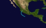
Tropical Storm Aletta
A tropical disturbance formed to the south of the Gulf of TehuantepecGulf of Tehuantepec
Gulf of Tehuantepec is a large body of water on the Pacific coast of the Isthmus of Tehuantepec, southeastern Mexico, at . Most of the hurricanes that form in the Eastern Pacific organize in or near this body of water...
on May 24; sea surface temperatures (SST's) in the area were around 88 °F (31.1 °C). The disturbance slowly organized over the next 60 hours, as it was detaching from the Intertropical Convergence Zone
Intertropical Convergence Zone
The Intertropical Convergence Zone , known by sailors as The Doldrums, is the area encircling the earth near the equator where winds originating in the northern and southern hemispheres come together....
(ITCZ). On May 28, Tropical Storm Aletta formed. It recurved to the northeast and made landfall in western Mexico on May 30. Effects were minimal.
Hurricane Connie
Hurricane Connie was the first major hurricane. It took a bizarre, twisting path but never made landfall.Hurricane Dolores
On June 13, a tropical disturbance south of Mexico showed signs of development. The following day, the system rapidly developed into Tropical Storm Dolores. By June 15, an eye-like featureEye (cyclone)
The eye is a region of mostly calm weather found at the center of strong tropical cyclones. The eye of a storm is a roughly circular area and typically 30–65 km in diameter. It is surrounded by the eyewall, a ring of towering thunderstorms where the second most severe weather of a cyclone...
appeared on satellite imagery as Dolores attained hurricane status. With peak winds of 80 mph (130 km/h), the storm made landfall
Landfall (meteorology)
Landfall is the event of a tropical cyclone or a waterspout coming onto land after being over water. When a waterspout makes landfall it is reclassified as a tornado, which can then cause damage inland...
near Acapulco. Once onshore, Dolores rapidly dissipated and was last noted on June 17.
Across Southwestern Mexico, Hurricane Dolores produced heavy rains that triggered widespread flooding and mudslides. Numerous roads sustained damage, separating communities from surrounding areas. At least 18 people were killed and 32 others were injured by the storm. Additionally, an estimated 173,000 people were affected across the country.
Hurricane Francesca
Francesca was a category 1 hurricane. It neared Baja California by the 17th but turned away before striking.Hurricane Gretchen
Gretchen was a category 2 hurricane that threatened southern Baja California, but it turned away without affecting land.Hurricane Ione
On August 19, a tropical disturbance was identified near the Intertropical Convergence ZoneIntertropical Convergence Zone
The Intertropical Convergence Zone , known by sailors as The Doldrums, is the area encircling the earth near the equator where winds originating in the northern and southern hemispheres come together....
well to the east-southeast of Hawaii. The next morning, the system developed into a tropical depression as it tracked towards the west-northwest. Later on August 20, the depression intensified into Tropical Storm Ione. However, cold air from a nearby stratocumulus field became entrained in Ione's circulation, causing it to weaken to a depression 24 hours later. Now moving towards the west-southwest, the system remained weak for nearly two days. On August 23, Ione rapidly intensified
Rapid deepening
Rapid deepening, also known as rapid intensification, is a meteorological condition that occurs when the minimum sea-level atmospheric pressure of a tropical cyclone decreases drastically in a short period of time. The National Weather Service describes rapid deepening as a decrease of...
as convection deepened and an eye feature appeared on satellite imagery. The storm subsequently attained hurricane status that evening before crossing 140°W
140th meridian west
The meridian 140° west of Greenwich is a line of longitude that extends from the North Pole across the Arctic Ocean, North America, the Pacific Ocean, the Southern Ocean, and Antarctica to the South Pole....
and entering the Central Pacific.
Intensification slowed on August 24 as Ione attained winds in excess of 100 mph (155 km/h). Over the next day, the system turned northward and attained its peak intensity late on August 25 with winds of 115 mph (185 km/h). Additionally, the storm attained an estimated minimum central pressure of 954 mbar (hPa; 28.17 inHg). Shortly after reaching this intensity, Ione weakened as it began a U-shaped curve, tracking northeast before turning towards the southwest. During the afternoon of August 27, the system was downgraded to a tropical storm. By August 29, Ione further weakened to a tropical depression and acquired a westward track before dissipating south of Hawaii on August 31.
Tropical Storm Olive
On August 21, just one day after Ione formed, another disturbance formed along the ITCZ and developed into a tropical depression the following day. Tracking generally towrads the west, the system slowly organized. By August 23, the depression intensified into Tropical Storm Olive well to the south of Hawaii. Olive briefly attained winds of 45 mph (75 km/h) before weakening to a tropical depression on August 24. Convection waned for the next 30 hours and Olive degenerated into a disturbance on August 25. The remnant vortex of the storm was last noted on August 26 roughly 210 mi (340 km) southeast of Johnston Island.Hurricane Kirsten
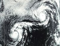
Hurricane Kirsten took an erratic path. After traveling northwest for a while, it reversed direction and backtracked to almost where it started. It then reversed direction again and underwent a Fujiwhara interaction with Hurricane Ione.Tropical Storm Lorraine
Tropical Storm Lorraine took an erratic, Z-shaped path during its life. It formed on August 23 and dissipated August 28.Hurricane Maggie
Hurricane Maggie was the strongest storm of the season. It reached Category 4 but never threatened land.Hurricane Norma
Hurricane Norma formed on September 9. It reached hurricane strength and made landfall the next day. Norma rapidly weakened and dissipated after landfall.Mudslides caused by Norma's rains killed three people.
Hurricane Orlene
In Central America, Hurricane Fifi killed around 8000 people. The storm weakened to a depression and crossed into the east Pacific. The system restrengthened and was renamed Tropical Storm Orlene. Orlene hugged the coast before recurving to the northeast and made landfall shortly after reaching Category 1 intensity.Other storms
In addition to the eighteen named storms, there were seven tropical depression during the course of the season.- July 9 – 13
- July 18 – 20
- July 21 – 26
- July 31 – August 11, 35 mph (55 km/h) 1001 mbar (hPa; 29.56 inHg)
- August 5 – 7
- September 3 – 7, 35 mph (55 km/h) 1001 mbar (hPa; 29.56 inHg)
- October 14 – 15, 30 mph (45 km/h) 1004 mbar (hPa; 29.65 inHg)
1974 storm names
The following names were used for named storms that formed in the eastern Pacific in 1974. It is the same list as the 1970 season1970 Pacific hurricane season
The 1970 Pacific hurricane season began on May 15, 1970 in the east Pacific, and on June 1, 1970 in the central Pacific. It ended on November 30, 1970. These dates conventionally delimit the period of time when tropical cyclones form in the eastern Pacific Ocean.This season had an above average...
, except for Aletta, which replaced Adele. This is the last time this list was used to name storms, as modern naming began in 1978.
|
|
Hurricane Fifi Hurricane Fifi was a catastrophic tropical cyclone that killed between 3,000 and 10,000 people in Honduras in September 1974, ranking it as the fourth deadliest Atlantic hurricane on record. Originating from a strong tropical wave on September 14, the system steadily tracked... |
In this season, the Central Pacific named storms from the western Pacific’s typhoon list. One name, Olive, was used.
See also
- List of Pacific hurricanes
- List of Pacific hurricane seasons
- 1974 Atlantic hurricane season1974 Atlantic hurricane seasonThe 1974 Atlantic hurricane season officially began on June 1, 1974, and lasted until November 30, 1974. These dates conventionally delimit the period of each year when most tropical cyclones form in the Atlantic basin...
- 1974 Pacific typhoon season1974 Pacific typhoon seasonThe 1974 Pacific typhoon season has no official bounds; it ran year-round in 1974, but most tropical cyclones tend to form in the northwestern Pacific Ocean between June and December...
- 1974 North Indian Ocean cyclone season
- Southern Hemisphere tropical cyclone seasons: 1973–74, 1974–75