

1767 Milestones
Encyclopedia
The 1767 Milestones are historic milestone
s located along the route of the Upper Boston Post Road between the cities of Boston and Springfield
in Massachusetts
. The 40 surviving milestones were added to the National Register of Historic Places
in 1971.
The first stone was erected by Paul Dudley, one of the prominent citizens of early 18th century Massachusetts, in Roxbury
, which was at the time a separate community. Roxbury was located at the end of the Boston Neck
, a narrow isthmus
separating the mainland from the Shawmut Peninsula
, where Boston was located. Travelers going by land from Boston to other areas had to travel over the neck and through Roxbury to reach their destinations. The Roxbury junction where Dudley placed the first stone was where several routes branched, heading south and west across New England.
Dudley erected several stones along the road from Boston to Cambridge which wound its way from Beacon Hill along what is now Washington Street through the Dudley Square area to what is now Huntington Avenue, then along Harvard Street through Brookline Village, Coolidge Corner
, and Allston crossing into Cambridge at the Great Bridge
, where modern JFK Street in Cambridge becomes North Harvard Street in Allston. The stones that Mr. Dudley erected have the initial PD on them, usually at the bottom of the stone. The most chatty of these milestones (not part of this collection), is inscribed P Dudley rather than PD, and is located on the corner of Centre and South Streets in Jamaica Plain.
Milestone
A milestone is one of a series of numbered markers placed along a road or boundary at intervals of one mile or occasionally, parts of a mile. They are typically located at the side of the road or in a median. They are alternatively known as mile markers, mileposts or mile posts...
s located along the route of the Upper Boston Post Road between the cities of Boston and Springfield
Springfield, Massachusetts
Springfield is the most populous city in Western New England, and the seat of Hampden County, Massachusetts, United States. Springfield sits on the eastern bank of the Connecticut River near its confluence with three rivers; the western Westfield River, the eastern Chicopee River, and the eastern...
in Massachusetts
Massachusetts
The Commonwealth of Massachusetts is a state in the New England region of the northeastern United States of America. It is bordered by Rhode Island and Connecticut to the south, New York to the west, and Vermont and New Hampshire to the north; at its east lies the Atlantic Ocean. As of the 2010...
. The 40 surviving milestones were added to the National Register of Historic Places
National Register of Historic Places
The National Register of Historic Places is the United States government's official list of districts, sites, buildings, structures, and objects deemed worthy of preservation...
in 1971.
The first stone was erected by Paul Dudley, one of the prominent citizens of early 18th century Massachusetts, in Roxbury
Roxbury, Massachusetts
Roxbury is a dissolved municipality and current neighborhood of Boston, Massachusetts, United States. It was one of the first towns founded in the Massachusetts Bay Colony in 1630, and became a city in 1846 until annexed to Boston on January 5, 1868...
, which was at the time a separate community. Roxbury was located at the end of the Boston Neck
Boston Neck
The Boston Neck or Roxbury Neck was an isthmus, a narrow strip of land connecting the then-peninsular city of Boston to the mainland city of Roxbury . The surrounding area was gradually filled in as the city of Boston expanded in population. -History:The Boston Neck was originally about wide at...
, a narrow isthmus
Isthmus
An isthmus is a narrow strip of land connecting two larger land areas usually with waterforms on either side.Canals are often built through isthmuses where they may be particularly advantageous to create a shortcut for marine transportation...
separating the mainland from the Shawmut Peninsula
Shawmut Peninsula
Shawmut Peninsula is the promontory of land on which Boston, Massachusetts was built. The peninsula, originally a mere in area, more than doubled in size due to land reclamation efforts, a feature of the history of Boston throughout the 19th century....
, where Boston was located. Travelers going by land from Boston to other areas had to travel over the neck and through Roxbury to reach their destinations. The Roxbury junction where Dudley placed the first stone was where several routes branched, heading south and west across New England.
Dudley erected several stones along the road from Boston to Cambridge which wound its way from Beacon Hill along what is now Washington Street through the Dudley Square area to what is now Huntington Avenue, then along Harvard Street through Brookline Village, Coolidge Corner
Coolidge Corner
Coolidge Corner is a neighborhood of Brookline, Massachusetts, centered around the intersection of Beacon Street and Harvard Street. The neighborhood takes its name from the Coolidge brothers' general store that opened in 1857 at that intersection on the location of today's S.S...
, and Allston crossing into Cambridge at the Great Bridge
Great Bridge (Cambridge)
The Great Bridge over the Charles River connected Cambridge, Massachusetts, to what is now known as Allston, Boston, Massachusetts. The Great Bridge was built in 1660-1662 at what was then called Brighton Street, and was the first bridge to span the Charles. A toll was authorized in 1670...
, where modern JFK Street in Cambridge becomes North Harvard Street in Allston. The stones that Mr. Dudley erected have the initial PD on them, usually at the bottom of the stone. The most chatty of these milestones (not part of this collection), is inscribed P Dudley rather than PD, and is located on the corner of Centre and South Streets in Jamaica Plain.
| Miles to Boston |
Year Placed |
Image | Location | Town | Notes |
|---|---|---|---|---|---|
| 01 | 1744 | Centre and Roxbury Streets 42°19′48"N 71°5′29"W |
Boston, Roxbury Roxbury, Massachusetts Roxbury is a dissolved municipality and current neighborhood of Boston, Massachusetts, United States. It was one of the first towns founded in the Massachusetts Bay Colony in 1630, and became a city in 1846 until annexed to Boston on January 5, 1868... |
This stone is called the "Parting Ways" Stone. | |
| 04 | 1729 | 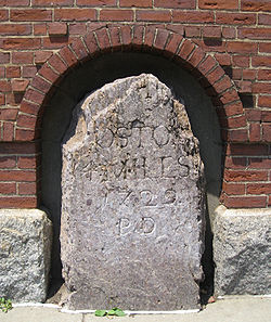 |
841 Huntington Avenue 42°19′57"N 71°6′42"W |
Boston, Mission Hill Mission Hill, Boston, Massachusetts Mission Hill is a 3/4 square mile neighborhood of Boston, with the population of approximately 18,000 people.The neighborhood is roughly bounded by Columbus Avenue and the Boston neighborhood of Roxbury to the east, Longwood Avenue to the northeast and the Olmsted designed Riverway/Jamaicaway and... |
|
| 05 | 1729 | 210 Harvard Ave. 42°20′24"N 71°7′17"W |
Brookline Brookline, Massachusetts Brookline is a town in Norfolk County, Massachusetts, United States, which borders on the cities of Boston and Newton. As of the 2010 census, the population of the town was 58,732.-Etymology:... |
||
| 06 | 1729 | 142 Harvard Ave. 42°21′5"N 71°7′56"W |
Boston, Brighton | ||
| 07 | 240 N. Harvard St. 42°21′52"N 71°7′42"W |
Boston, Brighton | |||
| 08 | 1734 | 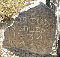 |
Old Burial Ground (Mass. Ave. and Garden St.) 42°22′29"N 71°7′10"W |
Cambridge Cambridge, Massachusetts Cambridge is a city in Middlesex County, Massachusetts, United States, in the Greater Boston area. It was named in honor of the University of Cambridge in England, an important center of the Puritan theology embraced by the town's founders. Cambridge is home to two of the world's most prominent... |
|
| 23 | River Road and Water Row 42°22′14"N 71°23′12"W |
Wayland Wayland, Massachusetts Wayland is a town in Middlesex County, Massachusetts, United States. The population was 12,994 at the 2010 census.For geographic and demographic information on Cochituate, which is part of Wayland, please see the article Cochituate, Massachusetts.-History:... |
|||
| 24 | Route 20 and Landham Road 42°21′39"N 71°24′8"W |
Sudbury Sudbury, Massachusetts Sudbury is a town in Middlesex County, Massachusetts, United States, population 17,659. The town was incorporated in 1639, with the original boundaries including what is now Wayland. Wayland split from Sudbury in 1780. When first incorporated, it included and parts of Framingham, Marlborough, Stow... |
|||
| 25 | Route 20 and Concord Road 42°21′44"N 71°24′59"W |
Sudbury Sudbury, Massachusetts Sudbury is a town in Middlesex County, Massachusetts, United States, population 17,659. The town was incorporated in 1639, with the original boundaries including what is now Wayland. Wayland split from Sudbury in 1780. When first incorporated, it included and parts of Framingham, Marlborough, Stow... |
|||
| 26 | Route 20 and Nobscot Road 42°21′36"N 71°25′30"W |
Sudbury Sudbury, Massachusetts Sudbury is a town in Middlesex County, Massachusetts, United States, population 17,659. The town was incorporated in 1639, with the original boundaries including what is now Wayland. Wayland split from Sudbury in 1780. When first incorporated, it included and parts of Framingham, Marlborough, Stow... |
|||
| 27 | Nobscot Road and Dudley Road 42.353533°N 71.431886°W |
Sudbury Sudbury, Massachusetts Sudbury is a town in Middlesex County, Massachusetts, United States, population 17,659. The town was incorporated in 1639, with the original boundaries including what is now Wayland. Wayland split from Sudbury in 1780. When first incorporated, it included and parts of Framingham, Marlborough, Stow... |
|||
| 28 | Route 20 and Peakham Road 42°21′35"N 71°27′32"W |
Sudbury Sudbury, Massachusetts Sudbury is a town in Middlesex County, Massachusetts, United States, population 17,659. The town was incorporated in 1639, with the original boundaries including what is now Wayland. Wayland split from Sudbury in 1780. When first incorporated, it included and parts of Framingham, Marlborough, Stow... |
|||
| 29 | Wayside Inn Road and Dutton Road 42°21′28"N 71°28′19"W |
Sudbury Sudbury, Massachusetts Sudbury is a town in Middlesex County, Massachusetts, United States, population 17,659. The town was incorporated in 1639, with the original boundaries including what is now Wayland. Wayland split from Sudbury in 1780. When first incorporated, it included and parts of Framingham, Marlborough, Stow... |
|||
| 33 | 143 E. Main St. 42°19′44"N 71°37′25"W |
Northborough Northborough, Massachusetts Northborough is a town in Worcester County, Massachusetts, United States. The official spelling of the town's name is "Northborough", but the shorter spelling "Northboro" is also used... |
|||
| 35 | Boston Post Road and Dean Park 42°17′45"N 71°41′43"W |
Shrewsbury Shrewsbury, Massachusetts -Demographics:As of the census of 2000, there were 31,640 people, 12,366 households, and 8,693 families residing in the town. The population density was . There were 12,696 housing units at an average density of... |
|||
| 43 | West Main St. near I-290 42°17′35"N 71°44′58"W |
Shrewsbury Shrewsbury, Massachusetts -Demographics:As of the census of 2000, there were 31,640 people, 12,366 households, and 8,693 families residing in the town. The population density was . There were 12,696 housing units at an average density of... |
|||
| 47 | Lincoln St. 42°17′10"N 71°47′28"W |
Worcester Worcester, Massachusetts Worcester is a city and the county seat of Worcester County, Massachusetts, United States. Named after Worcester, England, as of the 2010 Census the city's population is 181,045, making it the second largest city in New England after Boston.... |
|||
| 48 | 39 Salisbury St. 42°16′18.5"N 71°47′59"W |
Worcester Worcester, Massachusetts Worcester is a city and the county seat of Worcester County, Massachusetts, United States. Named after Worcester, England, as of the 2010 Census the city's population is 181,045, making it the second largest city in New England after Boston.... |
|||
| 53 | Route 9 at Collier's Corner 42°14′24"N 71°53′10"W |
Leicester Leicester, Massachusetts Leicester is a town in Worcester County, Massachusetts, United States. The population was 10,970 at the 2010 census.-History:Leicester was first settled in 1713 and was officially incorporated in 1714.... |
|||
| 54 | Main St. east of Paxton St. 42°14′43"N 71°54′30"W |
Leicester Leicester, Massachusetts Leicester is a town in Worcester County, Massachusetts, United States. The population was 10,970 at the 2010 census.-History:Leicester was first settled in 1713 and was officially incorporated in 1714.... |
|||
| 56 | Route 9 42°15′2"N 71°56′40"W |
Leicester Leicester, Massachusetts Leicester is a town in Worcester County, Massachusetts, United States. The population was 10,970 at the 2010 census.-History:Leicester was first settled in 1713 and was officially incorporated in 1714.... |
|||
| 57 | Route 9 42°15′21"N 71°57′21"W |
Leicester Leicester, Massachusetts Leicester is a town in Worcester County, Massachusetts, United States. The population was 10,970 at the 2010 census.-History:Leicester was first settled in 1713 and was officially incorporated in 1714.... |
|||
| 58 | Route 9 42°15′6"N 71°58′34"W |
Spencer Spencer, Massachusetts Spencer is a town in Worcester County, Massachusetts, United States. The population was 11,688 at the 2010 census.For geographic and demographic information on the census-designated place Spencer, please see the article Spencer , Massachusetts.... |
|||
| 59 | Route 9, Spencer Shopper's Village 42°14′46"N 71°59′20"W |
Spencer Spencer, Massachusetts Spencer is a town in Worcester County, Massachusetts, United States. The population was 11,688 at the 2010 census.For geographic and demographic information on the census-designated place Spencer, please see the article Spencer , Massachusetts.... |
|||
| 60 | Route 9 at Dewey St. 42°14′12"N 72°0′28"W |
Spencer Spencer, Massachusetts Spencer is a town in Worcester County, Massachusetts, United States. The population was 11,688 at the 2010 census.For geographic and demographic information on the census-designated place Spencer, please see the article Spencer , Massachusetts.... |
|||
| 61 | Route 9 42°13′52"N 72°1′40"W |
Spencer Spencer, Massachusetts Spencer is a town in Worcester County, Massachusetts, United States. The population was 11,688 at the 2010 census.For geographic and demographic information on the census-designated place Spencer, please see the article Spencer , Massachusetts.... |
|||
| 62 | Route 9 42°13′38"N 72°2′40"W |
East Brookfield East Brookfield, Massachusetts East Brookfield is a town in Worcester County, Massachusetts, United States. The population was 2,183 at the 2010 census.For geographic and demographic information on the census-designated place East Brookfield, please see the article East Brookfield , Massachusetts.- History :East Brookfield was... |
|||
| 63 | North Brookfield Rd. 42°13′42"N 72°4′1"W |
East Brookfield East Brookfield, Massachusetts East Brookfield is a town in Worcester County, Massachusetts, United States. The population was 2,183 at the 2010 census.For geographic and demographic information on the census-designated place East Brookfield, please see the article East Brookfield , Massachusetts.- History :East Brookfield was... |
|||
| 64 | Elm Hill Rd., near North Brookfield line 42°13′49"N 72°4′45"W |
Brookfield Brookfield, Massachusetts Brookfield is a town in Worcester County, Massachusetts, United States. The population was 3,390 at the 2010 census.-History:Brookfield was first settled in 1660 and was officially incorporated in 1718... |
|||
| 65 | Elm Hill Rd., east of North Brookfield Rd. 42°13′18"N 72°5′40"W |
Brookfield Brookfield, Massachusetts Brookfield is a town in Worcester County, Massachusetts, United States. The population was 3,390 at the 2010 census.-History:Brookfield was first settled in 1660 and was officially incorporated in 1718... |
|||
| 66 | Route 9 42°12′57"N 72°6′29"W |
Brookfield Brookfield, Massachusetts Brookfield is a town in Worcester County, Massachusetts, United States. The population was 3,390 at the 2010 census.-History:Brookfield was first settled in 1660 and was officially incorporated in 1718... |
|||
| 67 | Foster Hill Rd. 42°13′33"N 72°7′14"W |
West Brookfield West Brookfield, Massachusetts West Brookfield is a town in Worcester County, Massachusetts, United States. The population was 3,701 at the 2010 census. Lucy Stone was born in West Brookfield, and Noah Webster published his dictionary there.... |
|||
| 68 | East end of town common 42°14′10"N 72°8′15"W |
West Brookfield West Brookfield, Massachusetts West Brookfield is a town in Worcester County, Massachusetts, United States. The population was 3,701 at the 2010 census. Lucy Stone was born in West Brookfield, and Noah Webster published his dictionary there.... |
|||
| 69 | Route 9 42°14′1"N 72°9′22"W |
West Brookfield West Brookfield, Massachusetts West Brookfield is a town in Worcester County, Massachusetts, United States. The population was 3,701 at the 2010 census. Lucy Stone was born in West Brookfield, and Noah Webster published his dictionary there.... |
|||
| 70 | Route 67 near Old Patrick Rd. 42°13′19"N 72°10′22"W |
Warren Warren, Massachusetts Warren is a town in Worcester County, Massachusetts, United States. The population was 5,135 at the 2010 census.For geographic and demographic information on the census-designated place Warren, please see the article Warren , Massachusetts.- History :... |
|||
| 71 | Burbank and Washington Sts. 42°12′46"N 72°10′59"W |
Warren Warren, Massachusetts Warren is a town in Worcester County, Massachusetts, United States. The population was 5,135 at the 2010 census.For geographic and demographic information on the census-designated place Warren, please see the article Warren , Massachusetts.- History :... |
|||
| 72 | Bemis and Washington Rds. 42°12′7"N 72°11′22"W |
Warren Warren, Massachusetts Warren is a town in Worcester County, Massachusetts, United States. The population was 5,135 at the 2010 census.For geographic and demographic information on the census-designated place Warren, please see the article Warren , Massachusetts.- History :... |
|||
| 73 | Mape St. (Route 19) 42°11′53"N 72°12′20"W |
Warren Warren, Massachusetts Warren is a town in Worcester County, Massachusetts, United States. The population was 5,135 at the 2010 census.For geographic and demographic information on the census-designated place Warren, please see the article Warren , Massachusetts.- History :... |
|||
| 74 | Read St. east of West Warren Rd. 42°11′9"N 72°13′18"W |
Warren Warren, Massachusetts Warren is a town in Worcester County, Massachusetts, United States. The population was 5,135 at the 2010 census.For geographic and demographic information on the census-designated place Warren, please see the article Warren , Massachusetts.- History :... |
|||
| 99 | State Rd. (Route 20) at Springfield Armory Springfield Armory The Springfield Armory, located in the City of Springfield, Massachusetts - from 1777 until its closing in 1968 - was the primary center for the manufacture of U.S. military firearms. After its controversial closing during the Vietnam War, the Springfield Armory was declared Western Massachusetts'... 42°6′25"N 72°34′46"W |
Springfield Springfield, Massachusetts Springfield is the most populous city in Western New England, and the seat of Hampden County, Massachusetts, United States. Springfield sits on the eastern bank of the Connecticut River near its confluence with three rivers; the western Westfield River, the eastern Chicopee River, and the eastern... |
|||
| Source unless otherwise cited: NRHP nomination papers | |||||
See also
- National Register of Historic Places listings in Boston, MassachusettsNational Register of Historic Places listings in Boston, MassachusettsThis is a list of the National Register of Historic Places listings in Boston, Massachusetts.This is intended to be a complete list of the properties and districts on the National Register of Historic Places in Boston, Massachusetts, United States...
- National Register of Historic Places listings in Brookline, Massachusetts
- National Register of Historic Places listings in Cambridge, Massachusetts
- National Register of Historic Places listings in Middlesex County, Massachusetts
- National Register of Historic Places listings in Worcester County, Massachusetts
- National Register of Historic Places listings in Hampden County, Massachusetts