
Yolla Bolly-Middle Eel Wilderness
Encyclopedia
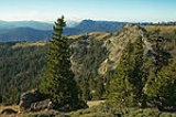
The Yolla Bolly-Middle Eel Wilderness is a federally designated wilderness area located 45 miles (72.4 km) west of Red Bluff
in the state of California
. Created by the Wilderness Act
of 1964, the land area was originally 170195 acres (68,875.5 ha).
The wilderness area was enlarged by the California Wilderness Act of 1984
, and again by the Northern California Coastal Wild Heritage Wilderness Act
of 2006, for a present total of 180877 acres (73,198.4 ha).
Most of it (172,998 acres) is managed by the US Forest Service and is within several national forest boundaries which are: Mendocino
, Shasta-Trinity
and Six Rivers
national forests. The balance of 7879 acres (31.9 km²) is on Bureau of Land Management
land. The name is from the Wintun
Native American language and means "snow-covered high peak".
Elevations range from 2700 feet (823 m) to 8092 feet (2,466.4 m) at Mount Linn
.
The regulations for wilderness areas, known as the L-20, became - with modifications by Secretary of Agriculture James Jardine
- the management policy for these areas. The L-20 Regulations used the term "primitive areas" with the purpose stated as to:
Of the three new "primitive areas" located in northern California, the Middle Eel-Yolla Bolla Primitive Area was the largest at 200000 acres (80,937.2 ha). The size was reduced to 107195 acres (43,380.3 ha) in 1931.
By the close of 1932 California had eighteen new primitive areas protecting 1900000 acres (768,903.4 ha).
Federal protection was given when this area became part of the National Wilderness Preservation System
, created by the passage of the Wilderness Act of 1964.
, the North Fork of the Eel, the Mad River
and the South Fork of the Trinity River
. The eastern side has the watersheds of Cottonwood and Thomes Creeks, which flow into the Sacramento River
. The very northern tip of the wilderness—around the summits of Black Rock Mountain and North Yolla Bolly Peak—are in the Klamath Mountains
.
Both the Middle and North Forks of the Eel River have Wild and Scenic River designation, as does the South Fork of the Trinity River. Several small, shallow lakes occur in remnant glacial basins near the highest peaks. Numerous springs are found off of the main ridgetops.
, mixed evergreen and Douglas fir forest types. Conifers include the California endemic foxtail pine
, ponderosa pine
, red and white firs, western white pine
, sugar pine
and incense-cedar. Other tree species include oaks, cottonwoods, and the rare Pacific yew. There are wet meadows and open grasslands supporting abundant deer herds (as well as cattle and sheep). Lower elevations have chamise, manzanita, and ceanothus.
Wildlife in the wilderness include bear, deer, gray fox, mountain lion, bobcat
, coyote, ringtail, northern flying squirrel, fisher and martin. The Northern Spotted Owl
can be found here, as well as eagles, hawks, turkey vultures and smaller birds like grouse, quail, and bandtailed pigeon.
Rainbow trout are found in most larger streams, such as in the South Fork of Cottonwood Creek, and in Black Rock Lake. The Middle Fork Eel River watershed has summer- and winter-run steelhead and spring-run chinook salmon but fishing is restricted.
, day-hiking
, camping
, fishing and nature photography. There are 15 trailheads all around the wilderness boundary with the most frequent users being hunters in the autumn months. Visitor use has one of the lowest densities among wilderness areas in California.
The Ides Cove Loop Trail is over 10 miles (16.1 km) in length and travels through very scenic areas. This trailhead is also the beginning of the Bigfoot Trail
. The US Forest Service encourages visitors to use Leave No Trace
ethics when visiting the wilderness to minimize impact to the environment.
Access to trailheads on the northwest side of the wilderness is available by paved road from Ruth. Other roads suitable for most passenger vehicles reach the south boundary from Covelo and the east boundary from Corning or Red Bluff.
Red Bluff
Red Bluff may refer to:* Red Bluff, California* Red Bluff, British Columbia, a community near Quesnel, British Columbia, Canada** Red Bluff First Nation, a First Nations band government headquartered near Quesnel, British Columbia...
in the state of California
California
California is a state located on the West Coast of the United States. It is by far the most populous U.S. state, and the third-largest by land area...
. Created by the Wilderness Act
Wilderness Act
The Wilderness Act of 1964 was written by Howard Zahniser of The Wilderness Society. It created the legal definition of wilderness in the United States, and protected some 9 million acres of federal land. The result of a long effort to protect federal wilderness, the Wilderness Act was signed...
of 1964, the land area was originally 170195 acres (68,875.5 ha).
The wilderness area was enlarged by the California Wilderness Act of 1984
California Wilderness Act of 1984
The California Wilderness Act of 1984 is a federal law , passed by the United States Congress on September 28, 1984, that authorized the addition of over within the state of California to the National Wilderness Preservation System....
, and again by the Northern California Coastal Wild Heritage Wilderness Act
Northern California Coastal Wild Heritage Wilderness Act
The Northern California Coastal Wild Heritage Wilderness Act is a U.S. federal law enacted in 2006 that enlarged existing wilderness boundaries and created new wilderness areas for protection under the National Wilderness Preservation System...
of 2006, for a present total of 180877 acres (73,198.4 ha).
Most of it (172,998 acres) is managed by the US Forest Service and is within several national forest boundaries which are: Mendocino
Mendocino National Forest
The Mendocino National Forest is located in the Coastal Mountain Range in northwestern California and comprises 913,306 acres...
, Shasta-Trinity
Shasta-Trinity National Forest
The Shasta-Trinity National Forest is a federally designated forest in northern California, USA. It is the largest National Forest in California and is managed by the United States Forest Service. The 2.2-million acre forest encompasses five wilderness areas, hundreds of mountain lakes and of...
and Six Rivers
Six Rivers National Forest
Six Rivers National Forest is a U.S. National Forest located in the northwestern corner of California. It was established on July 1, 1947 by U.S. President Harry S. Truman from portions of Klamath, Siskiyou and Trinity National Forests. Its over one million acres of land contain a variety of...
national forests. The balance of 7879 acres (31.9 km²) is on Bureau of Land Management
Bureau of Land Management
The Bureau of Land Management is an agency within the United States Department of the Interior which administers America's public lands, totaling approximately , or one-eighth of the landmass of the country. The BLM also manages of subsurface mineral estate underlying federal, state and private...
land. The name is from the Wintun
Wintun
Wintun is the name generally given to a group of related Native American tribes who live in Northern California, including the Wintu , Nomlaki , and Patwin tribes. Their range is from approximately present-day Lake Shasta to San Francisco Bay, along the western side of the Sacramento River to the...
Native American language and means "snow-covered high peak".
Elevations range from 2700 feet (823 m) to 8092 feet (2,466.4 m) at Mount Linn
Mount Linn
Mount Linn, at , is the easternmost summit on South Yolla Bolly Mountain, and is located in the Northern Coast Ranges of California in the Yolla Bolly-Middle Eel Wilderness. The summit is the highest point in the Northern Coast Ranges south of the Trinity Alps of the Klamath Mountains...
.
History
In 1927 Chief Forester William Greeley directed the district supervisors to study and recommend areas in the forests suitable for a new classification as "wilderness". By 1929 fourteen areas in the California Region 5 forests were proposed for this designation.The regulations for wilderness areas, known as the L-20, became - with modifications by Secretary of Agriculture James Jardine
James Jardine
James Jardine was a Scottish civil engineer, mathematician and geologist. He was the first person to determine mean sea level.He was born in Applegarth, Dumfriesshire, on 30 November 1776, the son of a farmer...
- the management policy for these areas. The L-20 Regulations used the term "primitive areas" with the purpose stated as to:
maintain primitive conditions of environment, transportation, habitation, and subsistence with a view to conserving the value of such areas for purposes of public education and recreation.
Of the three new "primitive areas" located in northern California, the Middle Eel-Yolla Bolla Primitive Area was the largest at 200000 acres (80,937.2 ha). The size was reduced to 107195 acres (43,380.3 ha) in 1931.
By the close of 1932 California had eighteen new primitive areas protecting 1900000 acres (768,903.4 ha).
Federal protection was given when this area became part of the National Wilderness Preservation System
National Wilderness Preservation System
The National Wilderness Preservation System of the United States protects federally managed land areas designated for preservation in their natural condition. It was established by the Wilderness Act upon the signature of President Lyndon B. Johnson on September 3, 1964...
, created by the passage of the Wilderness Act of 1964.
Waterways
Located mostly within the North Coast Ranges, the rugged topography of the Yolla Bolly-Middle Eel Wilderness protects headwaters of the Middle Fork of the Eel RiverEel River (California)
The Eel River is a major river system of the northern Pacific coast of the U.S. state of California. Approximately 200 miles long, it drains a rugged area in the California Coast Ranges between the Sacramento Valley and the ocean. For most of its course, the river flows northwest, parallel to the...
, the North Fork of the Eel, the Mad River
Mad River (California)
The Mad River is a river in upper Northern California. It flows for in a roughly northwest direction through Trinity County and then Humboldt County, draining a watershed into the Pacific Ocean north of the college town of Arcata near Arcata-Eureka Airport in McKinleyville...
and the South Fork of the Trinity River
Trinity River (California)
The Trinity River is the longest tributary of the Klamath River, approximately long, in northwestern California in the United States. It drains an area of the Coast Ranges, including the southern Klamath Mountains, northwest of the Sacramento Valley...
. The eastern side has the watersheds of Cottonwood and Thomes Creeks, which flow into the Sacramento River
Sacramento River
The Sacramento River is an important watercourse of Northern and Central California in the United States. The largest river in California, it rises on the eastern slopes of the Klamath Mountains, and after a journey south of over , empties into Suisun Bay, an arm of the San Francisco Bay, and...
. The very northern tip of the wilderness—around the summits of Black Rock Mountain and North Yolla Bolly Peak—are in the Klamath Mountains
Klamath Mountains
The Klamath Mountains, which include the Siskiyou, Marble, Scott, Trinity, Trinity Alps, Salmon, and northern Yolla-Bolly Mountains, are a rugged lightly populated mountain range in northwest California and southwest Oregon in the United States...
.
Both the Middle and North Forks of the Eel River have Wild and Scenic River designation, as does the South Fork of the Trinity River. Several small, shallow lakes occur in remnant glacial basins near the highest peaks. Numerous springs are found off of the main ridgetops.
Flora and fauna
The wilderness has Coast Range and Klamath montaneMontane
In biogeography, montane is the highland area located below the subalpine zone. Montane regions generally have cooler temperatures and often have higher rainfall than the adjacent lowland regions, and are frequently home to distinct communities of plants and animals.The term "montane" means "of the...
, mixed evergreen and Douglas fir forest types. Conifers include the California endemic foxtail pine
Foxtail Pine
The Foxtail Pine is a rare pine that is endemic to California, United States, where it is found in two areas with a separate subspecies in each, the typical subsp. balfouriana in the Klamath Mountains, and subsp. austrina in the southern Sierra Nevada.-Description:Foxtail Pine is a tree to tall,...
, ponderosa pine
Ponderosa Pine
Pinus ponderosa, commonly known as the Ponderosa Pine, Bull Pine, Blackjack Pine, or Western Yellow Pine, is a widespread and variable pine native to western North America. It was first described by David Douglas in 1826, from eastern Washington near present-day Spokane...
, red and white firs, western white pine
Western White Pine
Western White Pine, Pinus monticola in the family Pinaceae, is a species of pine that occurs in the mountains of the western United States and Canada, specifically the Sierra Nevada, the Cascade Range, the Coast Range, and the northern Rocky Mountains. The tree extends down to sea level in many...
, sugar pine
Sugar Pine
Pinus lambertiana, commonly known as the sugar pine or sugar cone pine, is the tallest and most massive pine, with the longest cones of any conifer...
and incense-cedar. Other tree species include oaks, cottonwoods, and the rare Pacific yew. There are wet meadows and open grasslands supporting abundant deer herds (as well as cattle and sheep). Lower elevations have chamise, manzanita, and ceanothus.
Wildlife in the wilderness include bear, deer, gray fox, mountain lion, bobcat
Bobcat
The bobcat is a North American mammal of the cat family Felidae, appearing during the Irvingtonian stage of around 1.8 million years ago . With twelve recognized subspecies, it ranges from southern Canada to northern Mexico, including most of the continental United States...
, coyote, ringtail, northern flying squirrel, fisher and martin. The Northern Spotted Owl
Northern Spotted Owl
The Northern Spotted Owl, Strix occidentalis caurina, is one of three Spotted Owl subspecies. A Western North American bird in the family Strigidae, genus Strix, it is a medium-sized dark brown owl sixteen to nineteen inches in length and one to one and one sixth pounds. Females are larger than males...
can be found here, as well as eagles, hawks, turkey vultures and smaller birds like grouse, quail, and bandtailed pigeon.
Rainbow trout are found in most larger streams, such as in the South Fork of Cottonwood Creek, and in Black Rock Lake. The Middle Fork Eel River watershed has summer- and winter-run steelhead and spring-run chinook salmon but fishing is restricted.
Geology
Rocks in the northern mountains are predominantly gray greenstone while the southern mountains include sandstone and serpentine of the Franciscan formation. Circque basins from former glaciers are seen above about 6000 feet (1,828.8 m) elevation. Extensive faulting in the rocks makes the region prone to erosion, slumping and landslides. One modern landslide near Ides Cove, on the north flank of Mount Linn, reached more than two miles (3 km) toward the South Fork Cottonwood Creek, upending old-growth forests and leaving large fissures on its perimeter.Recreation
Recreational activities include backpackingBackpacking (wilderness)
Backpacking combines the activities of hiking and camping for an overnight stay in backcountry wilderness...
, day-hiking
Hiking
Hiking is an outdoor activity which consists of walking in natural environments, often in mountainous or other scenic terrain. People often hike on hiking trails. It is such a popular activity that there are numerous hiking organizations worldwide. The health benefits of different types of hiking...
, camping
Camping
Camping is an outdoor recreational activity. The participants leave urban areas, their home region, or civilization and enjoy nature while spending one or several nights outdoors, usually at a campsite. Camping may involve the use of a tent, caravan, motorhome, cabin, a primitive structure, or no...
, fishing and nature photography. There are 15 trailheads all around the wilderness boundary with the most frequent users being hunters in the autumn months. Visitor use has one of the lowest densities among wilderness areas in California.
The Ides Cove Loop Trail is over 10 miles (16.1 km) in length and travels through very scenic areas. This trailhead is also the beginning of the Bigfoot Trail
Bigfoot Trail
The Bigfoot Trail is a U.S. long distance hiking trail in northern California . The trail begins in the Yolla Bolly-Middle Eel Wilderness and ends in Redwood National Park at the Pacific Ocean near Crescent City, California. A major focus along the trail is conifer diversity, passing 32 species in...
. The US Forest Service encourages visitors to use Leave No Trace
Leave No Trace
Leave No Trace is both a set of principles, and an organization that promotes those principles. The principles are designed to assist outdoor enthusiasts with their decisions about how to reduce their impacts when they hike, camp, picnic, snowshoe, run, bike, hunt, paddle, ride horses, fish, ski or...
ethics when visiting the wilderness to minimize impact to the environment.
Access to trailheads on the northwest side of the wilderness is available by paved road from Ruth. Other roads suitable for most passenger vehicles reach the south boundary from Covelo and the east boundary from Corning or Red Bluff.
External links
- Official website of Mendocino National Forest, wilderness areas. accessed 9-5-08
- National Wild and Scenic Rivers System website. accessed 9-5-08
- Wilderness.net website main page. accessed 9-5-08
- The Wilderness Society website. accessed 9-5-08
- Foxtail pine on Mount Linn