
Yoder, Kansas
Encyclopedia
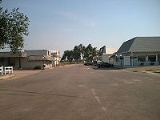
Yoder is a small unincorporated community
in Reno County
in the south-central part of the U.S. state
of Kansas
, about 10 miles southeast of the city of Hutchinson
on K-96
. Although Yoder is unincorporated, with no city government, it does have a U.S. Post Office and its own zip code (67585). As of the 2010 census, the CDP
population was 194.
Yoder is the hub of a local Amish
community and derives its name from its Amish founder. Aside from multiple local businesses, the community is also home to the former Hutchinson Naval Air Station
.
Unincorporated area
In law, an unincorporated area is a region of land that is not a part of any municipality.To "incorporate" in this context means to form a municipal corporation, a city, town, or village with its own government. An unincorporated community is usually not subject to or taxed by a municipal government...
in Reno County
Reno County, Kansas
Reno County is a county located in the U.S. state of Kansas. The county's population was 64,511 for the 2010 census. The largest city and county seat is Hutchinson. The Hutchinson Micropolitan Statistical Area includes all of Reno County.-19th century:In 1887, the Chicago, Kansas and Nebraska...
in the south-central part of the U.S. state
U.S. state
A U.S. state is any one of the 50 federated states of the United States of America that share sovereignty with the federal government. Because of this shared sovereignty, an American is a citizen both of the federal entity and of his or her state of domicile. Four states use the official title of...
of Kansas
Kansas
Kansas is a US state located in the Midwestern United States. It is named after the Kansas River which flows through it, which in turn was named after the Kansa Native American tribe, which inhabited the area. The tribe's name is often said to mean "people of the wind" or "people of the south...
, about 10 miles southeast of the city of Hutchinson
Hutchinson, Kansas
Hutchinson is the largest city in and the county seat of Reno County, Kansas, United States, northwest of Wichita, on the Arkansas River. It has been home to salt mines since 1887, thus its nickname of "Salt City", but locals call it "Hutch"...
on K-96
K-96 (Kansas highway)
K-96 is a state highway in central and southern Kansas. Its western terminus is at the Colorado state line east of Towner, Colorado, where it continues as Colorado State Highway 96; its eastern terminus since 1999 is at U.S. Route 54/U.S. Route 400 east of Wichita.The eastern terminus was once at...
. Although Yoder is unincorporated, with no city government, it does have a U.S. Post Office and its own zip code (67585). As of the 2010 census, the CDP
Census-designated place
A census-designated place is a concentration of population identified by the United States Census Bureau for statistical purposes. CDPs are delineated for each decennial census as the statistical counterparts of incorporated places such as cities, towns and villages...
population was 194.
Yoder is the hub of a local Amish
Amish
The Amish , sometimes referred to as Amish Mennonites, are a group of Christian church fellowships that form a subgroup of the Mennonite churches...
community and derives its name from its Amish founder. Aside from multiple local businesses, the community is also home to the former Hutchinson Naval Air Station
Hutchinson Naval Air Station
Sunflower Aerodrome Gliderport is a private glider airport in Reno County, Kansas, United States. It is located eight nautical miles south of Hutchinson, and 2 miles west-southwest of Yoder. It was opened in 1971. The facility is used for glider flying...
.
See also
- AmishAmishThe Amish , sometimes referred to as Amish Mennonites, are a group of Christian church fellowships that form a subgroup of the Mennonite churches...
- Sunflower Aerodrome Gliderport
- Hutchinson Naval Air StationHutchinson Naval Air StationSunflower Aerodrome Gliderport is a private glider airport in Reno County, Kansas, United States. It is located eight nautical miles south of Hutchinson, and 2 miles west-southwest of Yoder. It was opened in 1971. The facility is used for glider flying...
, south-west of Yoder.