
Yangon Central Railway Station
Encyclopedia
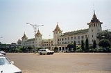
Yangon Central Railway Station , located in downtown Yangon
, is the largest railway station in Myanmar
. It is the gateway to Myanmar Railways
' 3,126-mile (5,031 km) rail network whose reach covers Upper Myanmar (Naypyidaw
, Mandalay
, Shwebo
), upcountry (Myitkyina
), Shan hills (Taunggyi
, Kalaw
) and the Taninthayi coast (Mawlamyine
, Ye).
The station was first built in 1877 by the British but destroyed by the retreating British in 1943 from advancing Japanese forces. The current station designed in traditional Burmese architectural style was completed in 1954. Yangon Central Railway Station has been designated a landmark building since 1996. In December 2007, the Yangon city government announced a master plan that will relocate Yangon Central to a satellite town, East Dagon
, 32 km from downtown at an unspecified date.
. The station was located on the southern side of the railway compound on the upper block of Phayre Street (now Pansodan Street) in the downtown area. The building was designed in the British Victorian style and the access roads were bordered by grassy lawns. The beauty of the property prompted locals to praise the new structure as the Fairy Station.
The station became a favorite target for Japanese bombers during World War II. In 1943 it was destroyed by British forces retreating to India.
The station was rebuilt following the war according to a design drawn by engineer Hla Thwin and based on Burmese traditional architectural styles. The new structure was 5110 square meters (55,000 sq ft) in size. To the north were grass lawns, gardens and wide access lanes. The new design was approved by the Railway Authority on 7 May 1946. Construction was started in January 1947 by engineer Sithu U Tin and completed in May 1954 at a total cost of K4.75 million. The opening ceremony of the new Yangon Central Railway Station was held on 5 June 1954.
The structure is listed on the Yangon City Heritage List
.
Yangon
Yangon is a former capital of Burma and the capital of Yangon Region . Although the military government has officially relocated the capital to Naypyidaw since March 2006, Yangon, with a population of over four million, continues to be the country's largest city and the most important commercial...
, is the largest railway station in Myanmar
Myanmar
Burma , officially the Republic of the Union of Myanmar , is a country in Southeast Asia. Burma is bordered by China on the northeast, Laos on the east, Thailand on the southeast, Bangladesh on the west, India on the northwest, the Bay of Bengal to the southwest, and the Andaman Sea on the south....
. It is the gateway to Myanmar Railways
Myanmar Railways
Myanmar Railways ; also spelled Myanma Railways; formerly Burma Railways) is the state-owned agency that operates the railway network in Myanmar. The metre gauge rail network consists of 858 stations, and generally spans north to south with branch lines to east and west. MR also operates the...
' 3,126-mile (5,031 km) rail network whose reach covers Upper Myanmar (Naypyidaw
Naypyidaw
Naypyidaw is the capital city of Burma, also known as Myanmar. It is administered as the Naypyidaw Union Territory, as per the 2008 Constitution. On 6 November 2005, the administrative capital of Myanmar was officially moved to a greenfield 3.2 km west of Pyinmana, and approximately...
, Mandalay
Mandalay
Mandalay is the second-largest city and the last royal capital of Burma. Located north of Yangon on the east bank of the Irrawaddy River, the city has a population of one million, and is the capital of Mandalay Region ....
, Shwebo
Shwebo
Shwebo is a city in Sagaing Division, Myanmar, located 113 km northwest of Mandalay between the Irrawaddy and the Mu rivers. The city, also called Ratanasingha , was the capital of Myanmar from 1752 to 1760 during the Konbaung period....
), upcountry (Myitkyina
Myitkyina
Myitkyina is the capital city of Kachin State in Myanmar , located from Yangon, and from Mandalay. In Burmese it means "near the big river", and in fact "Myitkyina" lies on the west bank of the Ayeyarwady River, just below from Myit-son of its two headstreams...
), Shan hills (Taunggyi
Taunggyi
-Transportation:The main access to Taunggyi is by road. A railway line that passes through Taunggyi was recently built in 1995, but at the moment it offers no passenger service. Regular railway passenger service to the rest of the country is through the town of Shwenyaung, twelve miles to the...
, Kalaw
Kalaw
For the bird locally known as Kalaw see Rufous HornbillKalaw is a hill town in the Shan State of Burma. It is located in Kalaw Township in Taunggyi District. The town was popular with the British during colonial rule. Kalaw is the main place of the novel by Jan Philipp Sendker, "Das...
) and the Taninthayi coast (Mawlamyine
Mawlamyine
Mawlamyine is the fourth largest city of Burma , situated 300 km south east of Yangon and 70 km south of Thaton, at the mouth of Thanlwin river...
, Ye).
The station was first built in 1877 by the British but destroyed by the retreating British in 1943 from advancing Japanese forces. The current station designed in traditional Burmese architectural style was completed in 1954. Yangon Central Railway Station has been designated a landmark building since 1996. In December 2007, the Yangon city government announced a master plan that will relocate Yangon Central to a satellite town, East Dagon
East Dagon Township
East Dagon Township is located in the easternmost part of Yangon, Myanmar. The township comprises 54 wards and three village tracts. It shares borders with Hlegu township in the north, North Dagon township in the west, and South Dagon township in the south and west...
, 32 km from downtown at an unspecified date.
History
Yangon Central Railway Station was first built in 1877 by the British to support Burma's first railway line, from Yangon to PyayPyay
Pyay is a town in the Bago Division in Burma. It has an estimated population of 123,800 . Pyay is positioned on the Ayeyarwady River and is northwest of Yangon....
. The station was located on the southern side of the railway compound on the upper block of Phayre Street (now Pansodan Street) in the downtown area. The building was designed in the British Victorian style and the access roads were bordered by grassy lawns. The beauty of the property prompted locals to praise the new structure as the Fairy Station.
The station became a favorite target for Japanese bombers during World War II. In 1943 it was destroyed by British forces retreating to India.
The station was rebuilt following the war according to a design drawn by engineer Hla Thwin and based on Burmese traditional architectural styles. The new structure was 5110 square meters (55,000 sq ft) in size. To the north were grass lawns, gardens and wide access lanes. The new design was approved by the Railway Authority on 7 May 1946. Construction was started in January 1947 by engineer Sithu U Tin and completed in May 1954 at a total cost of K4.75 million. The opening ceremony of the new Yangon Central Railway Station was held on 5 June 1954.
The structure is listed on the Yangon City Heritage List
Yangon City Heritage List
The Yangon City Heritage List is a list of man-made landmarks in Yangon, Myanmar, so designated by the city government, Yangon City Development Committee. The list consists of 188 structures , and is largely made up of mostly religious structures and British colonial era buildings. The list is...
.