
Wright Valley
Encyclopedia
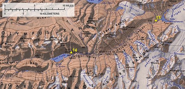
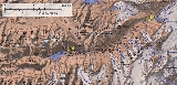
The Wright Valley is the central one of the three large Dry Valleys in the Transantarctic Mountains
Transantarctic Mountains
The three largest mountain ranges on the Antarctic continent are the Transantarctic Mountains , the West Antarctica Ranges, and the East Antarctica Ranges. The Transantarctic Mountains compose a mountain range in Antarctica which extend, with some interruptions, across the continent from Cape Adare...
, located west of McMurdo Sound
McMurdo Sound
The ice-clogged waters of Antarctica's McMurdo Sound extend about 55 km long and wide. The sound opens into the Ross Sea to the north. The Royal Society Range rises from sea level to 13,205 feet on the western shoreline. The nearby McMurdo Ice Shelf scribes McMurdo Sound's southern boundary...
at approximately 77°10′S 161°50′E. Wright Valley contains the Onyx River
Onyx River
The Onyx River is a meltwater stream which flows westward through the Wright Valley from Wright Lower Glacier and Lake Brownworth at the foot of the glacier to Lake Vanda, during a few months of the Antarctic summer....
, the largest river in Antarctica, Lake Brownworth
Lake Brownworth
Lake Brownworth is a meltwater lake immediately west of Wright Lower Glacier at the east end of Wright Valley, Victoria Land. The lake was mapped by the United States Geological Survey from surveys and air photos obtained in 1956–60. It was named by the Advisory Committee on Antarctic Names for...
, the origin of Onyx River, and Lake Vanda
Lake Vanda
Lake Vanda is a lake in Wright Valley, Victoria Land, Ross Dependency, Antarctica. The lake is 5 km long and has a maximum depth of 69 m. On its shore, New Zealand maintained Vanda Station from 1968 to 1995...
, which is fed by the Onyx River. Its southwestern branch, South Fork, is the location of Don Juan Pond
Don Juan Pond
Don Juan Pond, also called Lake Don Juan, is a small and very shallow hypersaline lake in the west end of Wright Valley , Victoria Land, Antarctica, west from Lake Vanda. It is wedged between the Asgard Range in the south and the Dais in the north. On the west end there is a small tributary and a...
. The upland area known as the Labyrinth
Labyrinth (Antarctica)
The Labyrinth is an extensive flat upland area which has been deeply eroded at the west end of Wright Valley, in Victoria Land. It was so named by the Victoria University of Wellington Antarctic Expedition because the eroded dolerite of which it is formed gives an appearance of a labyrinth....
is at the valley's west end.
Although portions of the interconnected valley system were discovered in 1903 by the Discovery expedition led by Captain Scott, the Wright Valley located near the centre of the system was not seen until aerial photographs of the region were made in 1947.
By the mid 1960s scientists were becoming increasingly intrigued by the paradoxical fact that the valley lay immediately adjacent to the permanent East Antarctic Ice Sheet, yet had remained ice-free for at least thousands of years. Furthermore, Lake Vanda, fed by summer melt water from the Onyx River, maintained impossibly warm water at its deepest point. Although covered by roughly 3 metres (9.8 ft) of ice year-round, lake temperatures of 25 °C (77 °F) had been reliably measured at a depth of 65 metres (213.3 ft). The lack of snow, warm lake temperatures, unusual rock features, desiccated seal carcasses, and an almost complete lack of plant life invited closer investigation.
Increasing summer field activity and a clear need to establish a winter record led New Zealand's Antarctic Division and the National Science Foundation of the United States to plan a more permanent base in the Valley. In 1968 New Zealand established Vanda Station
Vanda Station
Vanda Station was an Antarctic research base in the western highlands of the Ross Dependency, specifically on the shore of Lake Vanda, at the mouth of Onyx River, in the Wright Valley...
near the eastern end of Lake Vanda.