
William H. Putnam Memorial Bridge
Encyclopedia
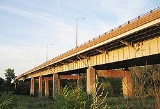
The Putnam Bridge is a bridge in the state of Connecticut
carrying the Route 3
Expressway over the Connecticut River
, connecting Interstate 91
in Wethersfield
and Route 2
in Glastonbury
. It is the southernmost crossing of the Connecticut River in the Hartford Area and carries an average of 50,800 vehicles per day.http://www.ct.gov/dot/LIB/dot/Documents/dpolicy/traflog/traflog.pdf
The bridge was originally to be a double-decker as part of a planned Interstate 491, a southeastern bypass around Hartford from Wethersfield
to East Hartford
. However, the project was cancelled in 1973, and the expressway portion of Route 3 from I-91 to Route 2 is all that was constructed from that project.
Connecticut
Connecticut is a state in the New England region of the northeastern United States. It is bordered by Rhode Island to the east, Massachusetts to the north, and the state of New York to the west and the south .Connecticut is named for the Connecticut River, the major U.S. river that approximately...
carrying the Route 3
Route 3 (Connecticut)
Route 3 is a long route connecting Middletown to the Glastonbury-East Hartford town line. It passes through the towns of Cromwell, Rocky Hill, Wethersfield, and Glastonbury. The northernmost of Route 3 is an expressway that was originally intended for the cancelled...
Expressway over the Connecticut River
Connecticut River
The Connecticut River is the largest and longest river in New England, and also an American Heritage River. It flows roughly south, starting from the Fourth Connecticut Lake in New Hampshire. After flowing through the remaining Connecticut Lakes and Lake Francis, it defines the border between the...
, connecting Interstate 91
Interstate 91
Interstate 91 is an Interstate Highway in the New England region of the United States. It provides the primary north–south thoroughfare in the western part of New England...
in Wethersfield
Wethersfield, Connecticut
Wethersfield is a town in Hartford County, Connecticut, United States. Many records from colonial times spell the name Weathersfield, while Native Americans called it Pyquag...
and Route 2
Route 2 (Connecticut)
Route 2 is a state highway in Connecticut and is in length. It is a primary state route, with a freeway section connecting Hartford to Norwich and a non-freeway section extending to Stonington.-Route description:...
in Glastonbury
Glastonbury, Connecticut
Glastonbury is a town in Hartford County, Connecticut, United States, founded in 1693. The population was 31,876 at the 2000 census. The town was named after Glastonbury in Somerset, England. Glastonbury is located on the banks of the Connecticut River, 7 miles southeast of Hartford. The town...
. It is the southernmost crossing of the Connecticut River in the Hartford Area and carries an average of 50,800 vehicles per day.http://www.ct.gov/dot/LIB/dot/Documents/dpolicy/traflog/traflog.pdf
The bridge was originally to be a double-decker as part of a planned Interstate 491, a southeastern bypass around Hartford from Wethersfield
Wethersfield, Connecticut
Wethersfield is a town in Hartford County, Connecticut, United States. Many records from colonial times spell the name Weathersfield, while Native Americans called it Pyquag...
to East Hartford
East Hartford, Connecticut
East Hartford is a town in Hartford County, Connecticut, United States. The population was 51,252 at the 2010 census.-Geography:...
. However, the project was cancelled in 1973, and the expressway portion of Route 3 from I-91 to Route 2 is all that was constructed from that project.