
Wildwood, Alberta
Encyclopedia
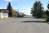
Wildwood is a hamlet
Hamlet (place)
A hamlet is usually a rural settlement which is too small to be considered a village, though sometimes the word is used for a different sort of community. Historically, when a hamlet became large enough to justify building a church, it was then classified as a village...
in west-central Alberta
Central Alberta
Central Alberta is a region located in the Canadian province of Alberta.Central Alberta is the most densely populated rural area in the province...
, Canada
Canada
Canada is a North American country consisting of ten provinces and three territories. Located in the northern part of the continent, it extends from the Atlantic Ocean in the east to the Pacific Ocean in the west, and northward into the Arctic Ocean...
within Yellowhead County
Yellowhead County, Alberta
Yellowhead County is a municipal district in west central Alberta, Canada.It is the only county in Alberta Division 14, and shares the boundaries with this census division.-History:*1994: Established as a Municipal District of Yellowhead No...
. It is located on the Yellowhead Highway
Yellowhead Highway
The Yellowhead Highway is a major east-west highway connecting the four western Canadian provinces of British Columbia, Alberta, Saskatchewan, and Manitoba. Although part of the Trans-Canada Highway system, the highway should not be confused with the more southerly, originally-designated...
(Highway 16), approximately 112 kilometres (69.6 mi) west of Edmonton and 82 kilometres (51 mi) east of Edson
Edson, Alberta
Edson is a town in west-central Alberta, Canada. It is located in Yellowhead County, west of Edmonton along the Yellowhead Highway and east of the intersection with Highway 47.- History :left|thumb|200px|Welcome Sign...
. The Yellowhead Highway's intersection with Cowboy Trail (Highway 22) is 9 kilometres (5.6 mi) east of the hamlet. The Lobstick River
Lobstick River
The Lobstick River is a small river in originating in west-central Alberta, Canada. It flows north from the foothills before entering Chip Lake. It then flows eastward through the community of Lobstick before joining the Pembina River, which in turn flows into the Athabasca River.The Lobstick...
, which flows from Chip Lake
Chip Lake
Chip Lake is a large lake in west-central Alberta. The Lobstick River flows through the lake. It in turn is a tributary of the Pembina River, which eventually flows into the Athabasca River....
to the west, runs through the hamlet.
Statistics Canada
Statistics Canada
Statistics Canada is the Canadian federal government agency commissioned with producing statistics to help better understand Canada, its population, resources, economy, society, and culture. Its headquarters is in Ottawa....
recognizes Wildwood as a designated place
Designated place
A designated place or DPL is a type of community or populated area identified by Statistics Canada for statistical purposes. DPLs are delineated for each decennial census as the statistical counterparts of incorporated places such as cities, towns and villages.DPLs are communities that lack...
.
History
Originally named Junkins, Wildwood was established in 1908 by a group of 20 African-American immigrants as a block settlementBlock Settlement
A block settlement is particular type of land distribution which allows settlers with the same ethnicity to form small colonies.This settlement type was used throughout western Canada between the late 19th and early 20th centuries...
.
Demographics
As of 2006, Wildwood had a total population of 277 living in 132 dwellings. With a land area of 0.89 km² (0.343630921147356 sq mi), it has a population densityPopulation density
Population density is a measurement of population per unit area or unit volume. It is frequently applied to living organisms, and particularly to humans...
of 310.7 /km2.