

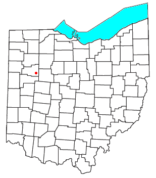
Westminster, Ohio
Encyclopedia
Unincorporated area
In law, an unincorporated area is a region of land that is not a part of any municipality.To "incorporate" in this context means to form a municipal corporation, a city, town, or village with its own government. An unincorporated community is usually not subject to or taxed by a municipal government...
in western Auglaize Township
Auglaize Township, Allen County, Ohio
Auglaize Township is one of the twelve townships of Allen County, Ohio, United States. The 2000 census found 2,850 people in the township, 2,359 of whom lived in the unincorporated portions of the township.-Geography:...
, Allen County
Allen County, Ohio
Allen County is a county located in the U.S. state of Ohio. Its population was 106,331 as of the 2010 census. It is included in the Lima, Ohio Metropolitan Statistical Area as well as the Lima–Van Wert–Wapakoneta Combined Statistical Area....
, Ohio
Ohio
Ohio is a Midwestern state in the United States. The 34th largest state by area in the U.S.,it is the 7th‑most populous with over 11.5 million residents, containing several major American cities and seven metropolitan areas with populations of 500,000 or more.The state's capital is Columbus...
, United States
United States
The United States of America is a federal constitutional republic comprising fifty states and a federal district...
. It lies along State Route 117 just north of its intersection with State Route 196
Ohio State Route 196
State Route 196 is a long north–south state highway in the western portion of the U.S. state of Ohio. The southern terminus of SR 196 is at a signalized intersection nearly southeast of Waynesfield that marks its junction with U.S. Route 33 and SR 385, which has its...
, 6½ miles (10½ km) north of Waynesfield
Waynesfield, Ohio
Waynesfield is a village in Auglaize County, Ohio, United States with a population of 803 as of the 2000 U.S. census. It is included in the Wapakoneta, Ohio Micropolitan Statistical Area.-Geography:Waynesfield is located at ....
and 7½ miles (12 km) southeast of the downtown part of the city of Lima
Lima, Ohio
Lima is a city in and the county seat of Allen County, Ohio, United States. The municipality is located in northwestern Ohio along Interstate 75 approximately north of Dayton and south-southwest of Toledo....
, the county seat
County seat
A county seat is an administrative center, or seat of government, for a county or civil parish. The term is primarily used in the United States....
of Allen County. The upper reaches of the Auglaize River
Auglaize River
The Auglaize River is a tributary of the Maumee River in northwestern Ohio in the United States. It drains a primarily rural farming area in the watershed of Lake Erie. The name of the river either comes from a Shawnee phrase meaning "fallen timbers" or a French term for "frozen water."It rises in...
flow past the community.
Rudolph Foods is located in the village. The facility processes pork rinds, and as a result, Westminster is known as "The Pork Rind Capital of the World," as is evidenced by the smell of bacon that frequently envelops the community.
Westminster is part of the Lima
Lima, Ohio
Lima is a city in and the county seat of Allen County, Ohio, United States. The municipality is located in northwestern Ohio along Interstate 75 approximately north of Dayton and south-southwest of Toledo....
Metropolitan Statistical Area
Lima, Ohio metropolitan area
The Lima Metropolitan Statistical Area, as defined by the United States Census Bureau, is an area consisting of one county – Allen – in Northwest Ohio, anchored by the city of Lima. As of the 2000 census, the MSA had a population of 108,473 .-History:The Lima metropolitan area was first...
.