
West Bank Closures
Encyclopedia
The West Bank
closure system is a series of obstacles including permanent and partially manned checkpoints, concrete roadblocks and barriers, metal gates, earthmounds, tunnels, trenches, and an elaborate set of permit restrictions that controls and restricts Palestinian
movement.
i citizens from Palestinian terrorist attacks that have killed over 1,000 Israelis since September 2000. In practice, the closure system has divided communities from their land and one another and restricted Palestinian access to health and education services, their places of work and sites of religious worship.
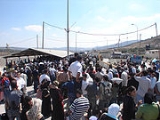
 Manned checkpoints usually consist of a barrier with observation towers and other physical blocks used to control pedestrian and vehicular access.
There are 8 partial checkpoints, i.e.; an established checkpoint operating periodically. Partial checkpoints also exist within 'Israel proper' and are applied to all citizens. A metal gate, often manned by IDF, is sometimes used to control movement along roads. There are 67 of these in the West Bank.
There are also flying checkpoints which are unannounced spot-checks spontaneously erected for a period of time, often on key transportation routes at peak travelling times. In July, August and September 2006, flyings checkpoints were used an average of 165 times per week.
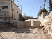 A series of one metre concrete blocks or mounds of rubble, dirt and rocks are sometimes used to obstruct Palestinian vehicle access to settlements or to prevent bypassing of checkpoints when entering controlled access routes. There are currently 50 block sites and 275 separate earth mounds in the West Bank. There are currently 10 separate trenches in the West Bank making 31,000 metres of trenches. These are placed to prevent vehicle access.
, the 'closed area' between the Green Line
and the Israeli West Bank Barrier
and for entering East Jerusalem
.
 Allows restricted movement through the West Bank barrier
to Palestinian lands and to Israel
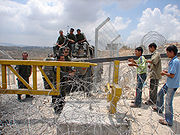
. Permits are required for Palestinians to pass through a gate. Thirty-eight of the seventy-three Barrier gates are open to Palestinians with appropriate permits.
West Bank
The West Bank ) of the Jordan River is the landlocked geographical eastern part of the Palestinian territories located in Western Asia. To the west, north, and south, the West Bank shares borders with the state of Israel. To the east, across the Jordan River, lies the Hashemite Kingdom of Jordan...
closure system is a series of obstacles including permanent and partially manned checkpoints, concrete roadblocks and barriers, metal gates, earthmounds, tunnels, trenches, and an elaborate set of permit restrictions that controls and restricts Palestinian
Palestinian people
The Palestinian people, also referred to as Palestinians or Palestinian Arabs , are an Arabic-speaking people with origins in Palestine. Despite various wars and exoduses, roughly one third of the world's Palestinian population continues to reside in the area encompassing the West Bank, the Gaza...
movement.
Rationale and impact
The Israeli government states that the system is designed to protect IsraelIsrael
The State of Israel is a parliamentary republic located in the Middle East, along the eastern shore of the Mediterranean Sea...
i citizens from Palestinian terrorist attacks that have killed over 1,000 Israelis since September 2000. In practice, the closure system has divided communities from their land and one another and restricted Palestinian access to health and education services, their places of work and sites of religious worship.
Physical makeup
The number of checkpoints and physical obstacles and their uses and locations varies. While some are located so as to restrict Palestinian access to Israeli areas, most of them "do not restrict the interaction between Israelis and Palestinians, but rather between Palestinians and Palestinians". Organizations like the United Nations Office for the Coordination of Humanitarian Affairs, who track such developments have reported a recent upward trend; increasing from 376 in August 2005 to 528, as of September 2006. Of these, 83 were checkpoints manned by IDF and/or Border Police and another were 445 unmanned checkpoints and obstacles.Checkpoints
There are 8 partial checkpoints, i.e.; an established checkpoint operating periodically. Partial checkpoints also exist within 'Israel proper' and are applied to all citizens. A metal gate, often manned by IDF, is sometimes used to control movement along roads. There are 67 of these in the West Bank.
There are also flying checkpoints which are unannounced spot-checks spontaneously erected for a period of time, often on key transportation routes at peak travelling times. In July, August and September 2006, flyings checkpoints were used an average of 165 times per week.
Observation towers
These are elevated military towers to monitor/control Palestinian pedestrian and vehicular access.Anti-vehicle barriers
Road barriers
Secures the passage of Israeli settlers on restricted roads. These fences impede Palestinians from traveling over major roads leading to the main cities. There are 25 of these in the West Bank totalling 37,600 metres.Permit system
The permit system is complex and applied differently from region to region. A permit eases travel and reduces the risk of being turned back at a checkpoint. Permits are necessary for crossing specific checkpoints, accessing the Jordan ValleyJordan Valley (Middle East)
The Jordan Valley forms part of the larger Jordan Rift Valley. It is 120 kilometers long and 15 kilometers wide, where it runs from Lake Tiberias in the north to northern Dead Sea in the south. It runs for an additional 155 kilometer south of the Dead Sea to Aqaba, an area also known as Wadi...
, the 'closed area' between the Green Line
Green Line (Israel)
Green Line refers to the demarcation lines set out in the 1949 Armistice Agreements between Israel and its neighbours after the 1948 Arab-Israeli War...
and the Israeli West Bank Barrier
Israeli West Bank barrier
The Israeli West Bank barrier is a separation barrier being constructed by the State of Israel along and within the West Bank. Upon completion, the barrier’s total length will be approximately...
and for entering East Jerusalem
East Jerusalem
East Jerusalem or Eastern Jerusalem refer to the parts of Jerusalem captured and annexed by Jordan in the 1948 Arab-Israeli War and then captured and annexed by Israel in the 1967 Six-Day War...
.
Barrier gates
Israeli West Bank barrier
The Israeli West Bank barrier is a separation barrier being constructed by the State of Israel along and within the West Bank. Upon completion, the barrier’s total length will be approximately...
to Palestinian lands and to Israel
Israel
The State of Israel is a parliamentary republic located in the Middle East, along the eastern shore of the Mediterranean Sea...
. Permits are required for Palestinians to pass through a gate. Thirty-eight of the seventy-three Barrier gates are open to Palestinians with appropriate permits.
External links
- Report by World Bank Technical Team on Movement and Access Restrictions in the West Bank
- National Lawyer's Guild Delegation
- U.N. Office for the Coordination of Humanitarian Affairs - Occupied Palestinian Territory
- OCHA oPt map of West Bank closures - Jun 06
- OCHA oPt map of East Jerusalem region closures - Jun 06
- OCHA oPt map of Nablus region closures - Jun 06
- OCHA oPt map of Tubas region closures - Jun 06
- OCHA oPt map of Salfit region closures - Jun 06
- OCHA oPt map of Ramallah region closures - Jun 06
- OCHA oPt map of Qalqiliya region closures - Jun 06
- OCHA oPt map of Jenin region closures - Jun 06
- OCHA oPt map of Hebron region closures - Jun 06
- OCHA oPt map of Bethlehem region closures - Jun 06
- OCHA oPt map of Jericho region closures - Jun 06
- OCHA oPt map of Tulkarm region closures - Jun 06