
Weaver's Mill Covered Bridge
Encyclopedia
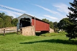
Weaver's Mill Covered Bridge is a covered bridge
that spans the Conestoga River
in Lancaster County
, Pennsylvania
, United States
. The 85 feet (25.9 m), 15 feet (4.6 m) bridge was built in 1878 by B. C. Carter and J. F. Stauffer across Conestoga River
. It is also known as Isaac Shearer's Mill Bridge.
The bridge has a single span, wooden, double Burr arch trusses design with the addition of steel hanger rods. It is painted red, the traditional color of Lancaster County covered bridges, on both the inside and outside. Both approaches to the bridge are painted in the traditional white color.
The bridge's WGCB
Number is 38-36-02. Added in 1980, it is listed on the National Register of Historic Places
as structure number 80003511. It is located at 40°8′28.2"N 75°59′52.2"W (40.14117, -75.99783).
Covered bridge
A covered bridge is a bridge with enclosed sides and a roof, often accommodating only a single lane of traffic. Most covered bridges are wooden; some newer ones are concrete or metal with glass sides...
that spans the Conestoga River
Conestoga River
The Conestoga River, also referred to as Conestoga Creek, is a tributary of the Susquehanna River flowing through the center of Lancaster County, Pennsylvania.-Geography:...
in Lancaster County
Lancaster County, Pennsylvania
Lancaster County, known as the Garden Spot of America or Pennsylvania Dutch Country, is a county located in the southeastern part of the Commonwealth of Pennsylvania, in the United States. As of 2010 the population was 519,445. Lancaster County forms the Lancaster Metropolitan Statistical Area, the...
, Pennsylvania
Pennsylvania
The Commonwealth of Pennsylvania is a U.S. state that is located in the Northeastern and Mid-Atlantic regions of the United States. The state borders Delaware and Maryland to the south, West Virginia to the southwest, Ohio to the west, New York and Ontario, Canada, to the north, and New Jersey to...
, United States
United States
The United States of America is a federal constitutional republic comprising fifty states and a federal district...
. The 85 feet (25.9 m), 15 feet (4.6 m) bridge was built in 1878 by B. C. Carter and J. F. Stauffer across Conestoga River
Conestoga River
The Conestoga River, also referred to as Conestoga Creek, is a tributary of the Susquehanna River flowing through the center of Lancaster County, Pennsylvania.-Geography:...
. It is also known as Isaac Shearer's Mill Bridge.
The bridge has a single span, wooden, double Burr arch trusses design with the addition of steel hanger rods. It is painted red, the traditional color of Lancaster County covered bridges, on both the inside and outside. Both approaches to the bridge are painted in the traditional white color.
The bridge's WGCB
World Guide to Covered Bridges
The World Guide to Covered Bridges is a covered bridge numbering system. The system was invented by John Diehl, the chairman of the Ohio Covered Bridge Committee. The committee first used the numbering system in 1953 to publish a list of covered bridges in Ohio....
Number is 38-36-02. Added in 1980, it is listed on the National Register of Historic Places
National Register of Historic Places
The National Register of Historic Places is the United States government's official list of districts, sites, buildings, structures, and objects deemed worthy of preservation...
as structure number 80003511. It is located at 40°8′28.2"N 75°59′52.2"W (40.14117, -75.99783).
Dimensions
- Length: 85 feet (25.9 m) total length
- Width: 15 feet (4.6 m) total width