

Wards of the City of Ottawa
Encyclopedia
In the City of Ottawa
City of Ottawa
The City of Ottawa is the corporate entity of municipal government in Ottawa, Ontario, Canada. The corporation is responsible for provision of services to the public as well as enforcement of municipal by-laws...
, Canada
Canada
Canada is a North American country consisting of ten provinces and three territories. Located in the northern part of the continent, it extends from the Atlantic Ocean in the east to the Pacific Ocean in the west, and northward into the Arctic Ocean...
a ward is an electoral district
Electoral district
An electoral district is a distinct territorial subdivision for holding a separate election for one or more seats in a legislative body...
within a municipality
Municipality
A municipality is essentially an urban administrative division having corporate status and usually powers of self-government. It can also be used to mean the governing body of a municipality. A municipality is a general-purpose administrative subdivision, as opposed to a special-purpose district...
used in local politics. Wards are named after neighbourhood
Neighbourhood
A neighbourhood or neighborhood is a geographically localised community within a larger city, town or suburb. Neighbourhoods are often social communities with considerable face-to-face interaction among members. "Researchers have not agreed on an exact definition...
s, thoroughfare
Thoroughfare
A thoroughfare is a place of transportation intended to connect one location to another. Highways, roads, and trails are examples of thoroughfares used by a variety of general traffic. On land a thoroughfare may refer to anything from a rough trail to multi-lane highway with grade separated...
s, parish
Parish
A parish is a territorial unit historically under the pastoral care and clerical jurisdiction of one parish priest, who might be assisted in his pastoral duties by a curate or curates - also priests but not the parish priest - from a more or less central parish church with its associated organization...
es, landmark
Landmark
This is a list of landmarks around the world.Landmarks may be split into two categories - natural phenomena and man-made features, like buildings, bridges, statues, public squares and so forth...
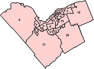
s, geographical features and in some cases historical figures connected to the area, and numbered. There are 23 wards in Ottawa.
Current wards
| # | Name | Population (2006) | Area (sq. km) | Named for |
|---|---|---|---|---|
| 1 | Orléans Ward Orléans Ward Orléans Ward is a city ward in the city of Ottawa, Canada. It was created before the 2000 Election when the area was amalgamated into the city of Ottawa. The ward covers much of the suburban community of Orleans in the east of the city. Previous to that, the ward existed in the Regional... |
46,000 | 25.5 | Orleans Orléans, Ontario Orleans , also written Orléans, is a suburban area within the city of Ottawa, Ontario, Canada. It is located in the eastern part of the city along the Ottawa River, about from downtown Ottawa. The Canada 2006 Census gave Orleans a population of 95,491. It became a ward of the City of Ottawa in 2001... |
| 2 | Innes Ward Innes Ward Innes is a city ward in the city of Ottawa, Canada. It includes the community of Blackburn Hamlet as well as the neighbourhoods of Orléans Village, Chateau Neuf and Chapel Hill in Orléans. It also includes the part of the community of Notre Dame des Champs formerly in the city of Gloucester. The... |
37,820 | 31.1 | Innes Road |
| 3 | Barrhaven Ward Barrhaven Ward Barrhaven Ward is a city ward in Ottawa, Canada. Prior to 2006, the ward was known as Bell-South Nepean Ward.The ward consists of the neighbourhoods of Cedarhill Estates, Orchard Estates, The Meadows, Pheasant Run, Fraservale, Barrhaven, Knollsbrook and Longfields.Prior to 2006, the ward was much... |
36,815 | 26.1 | Barrhaven |
| 4 | Kanata North Ward Kanata North Ward Kanata North Ward is a ward in the city of Ottawa,Ontario, Canada. The ward was created in 2006 when its precessor, Kanata Ward, split in two main parts. The original Kanata Ward covered all of the former City of Kanata... |
26,510 | 24.2 | Kanata Kanata, Ontario Situated in the Ottawa Valley, Kanata is located about west-southwest of Downtown Ottawa along Highway 417 at a latitude of 45°18' North and a longitude of 75°55' West, with an area of . Its northern end is just to the west of the Ottawa River.... |
| 5 | West Carleton-March Ward West Carleton-March Ward West Carleton-March Ward is a city ward in Ottawa, Canada.The ward was created for the 2000 election when West Carleton Township was amalgamated into the new city of Ottawa. At that time, the ward was called West Carleton Ward. It consisted of the former West Carleton Township. In 2006, the... |
21,455 | 763 | West Carleton Twp. West Carleton Township, Ontario West Carleton is a historic township in Eastern Ontario, Canada. It is located in the rural parts of the new City of Ottawa, west of Kanata. Its northern boundary is the Ottawa River.... & March Twp. March Township, Ontario March Township is a geographic township and former municipality originally part of Carleton County in eastern Ontario, Canada. It is currently part of the City of Ottawa... |
| 6 | Stittsville Ward | 19,410 | 16.3 | Stittsville Stittsville, Ontario Stittsville is a suburban community in the western part of Ottawa, Ontario, Canada. A part of the National Capital Region, Stittsville is located immediately to the south-west of Kanata, and about from downtown Ottawa.-History:... |
| 7 | Bay Ward Bay Ward Bay Ward is a municipal ward in Ottawa, Canada. It covers much of the western portion of the old city of Ottawa as well as some portions of what was once Nepean. The ward runs from Sherbourne and Maitland in the east to March Road in the west. The southern border in the Queensway while the northern... |
43,995 | 64.2 | Britannia, Crystal, Graham & Shirleys Bay |
| 8 | College Ward College Ward College Ward is a city ward in Ottawa, Canada's west end. The ward covers the neighbourhoods of Bells Corners, Qualicum, Graham Park, Leslie Park, Redwood, Kenson Park, Bel-Air Park, Bel-Air Heights, Braemar Park, Copeland Park, Briar Green, Centrepointe, Navaho, City View, Ryan Farm, Meadowlands... |
50,350 | 46.2 | Algonquin College Algonquin College Algonquin College of Applied Arts and Technology is a publicly funded English-language college and member of Polytechnics Canada located in Ottawa, Ontario, Canada. The college serves the National Capital Region and the outlying areas of Eastern Ontario and Western Quebec... |
| 9 | Knoxdale-Merivale Ward Knoxdale-Merivale Ward Knoxdale-Merivale is a city ward in Ottawa, Ontario. Located in the city's west end, the ward is bordered to the east by the Rideau River and Fisher Avenue, the northern boundaries of the community of Barrhaven to the south, Ontario Highway 416 and Cedarview Road to the west and to the north by the... |
38,070 | 47.5 | Knoxdale Road and Merivale Road |
| 10 | Gloucester-Southgate Ward Gloucester-Southgate Ward Gloucester-Southgate Ward is a city ward located in Ottawa, Ontario. Located in the city's south end, the ward includes Gloucester Glen east of the Rideau River, most of the Ottawa International Airport, CFB Uplands, Blossom Park, Greenboro, portions of Heron Gate south of Walkley Road, the Ottawa... |
44,380 | 67.2 | Gloucester Gloucester, Ontario Gloucester is a suburb of and within the City of Ottawa. Gloucester Township was established in 1792 and originally included lands east of the Rideau River from the Ottawa River south to Manotick. It was incorporated as a township in 1850 and became a city in 1981... and Ottawa South Ottawa South Ottawa South is a federal electoral district in Ottawa in the Canadian province of Ontario. It is represented in the Canadian House of Commons by David McGuinty, brother of Ontario Premier and Ottawa South MPP Dalton McGuinty. The riding was created in 1987 from parts of Ottawa—Vanier, Ottawa... |
| 11 | Beacon Hill-Cyrville Ward Beacon Hill-Cyrville Ward Beacon Hill-Cyrville Ward is a city ward in Ottawa, Ontario. Located in the city's east end, the ward is bordered to the west by Blair Ward from the Ottawa River to Ogilvie Road and St. Laurent Boulevard south of it, the south by the Via Rail train line and Innes Ward, to the east by Green's Creek... |
32,235 | 41.2 | Beacon Hill and Cryville Road |
| 12 | Rideau-Vanier Ward Rideau-Vanier Ward Rideau-Vanier Ward is a ward in the city of Ottawa, Canada, designated as Ward 12 and represented on Ottawa City Council. It was originally created in 1994 as a Ward on Regional Council.... |
39,360 | 7.9 | Rideau River Rideau River thumb|Rapids on the Rideau River opposite [[Carleton University]].The Rideau River is a Southern Ontario river which flows north from Upper Rideau Lake and empties into the Ottawa River at Rideau Falls in Ottawa, Ontario. Its length is 146 km... and Vanier Vanier, Ontario -External links:**... |
| 13 | Rideau-Rockcliffe Ward Rideau-Rockcliffe Ward Rideau-Rockcliffe Ward is a city ward in Ottawa, Ontario. Located in the city's east end, the ward covers the neighbourhoods of New Edinburgh, Manor Park, Rockcliffe Park, CFB Rockcliffe, Overbrook, Lindenlea, Viscount Alexander Park, Finter Quarries, Forbes, Castle Heights and part of Carson... |
37,280 | 19.8 | Rideau River and Rockcliffe Park |
| 14 | Somerset Ward Somerset Ward Somerset is a city ward in the city of Ottawa, Canada. It covers the neighbourhoods of Downtown Ottawa, Centretown, Lebreton Flats and most of Centretown West. It is Ottawa's smallest and most dense ward. It is represented on Ottawa City Council by Diane Holmes. It has an area of 6.5 km² and... |
33,515 | 6.5 | Somerset Street |
| 15 | Kitchissippi Ward Kitchissippi Ward Kitchissippi Ward is a city ward in the city of Ottawa, Canada. It gets its name from the Algonquin word for Great River. The ward is slightly west of downtown, and covers the neighbourhoods of Broadview, Champlain Park, Civic Hospital, Hampton Park, Highland Park, Hintonburg, Island Park,... |
36,105 | 15.1 | Kitchissippi Lookout |
| 16 | River Ward River Ward River Ward is city ward located in Ottawa, Ontario. Located in the central west/south central portion of the city, the ward includes the communities of Carlington, Skyline, Parkwood Hills, Fisher Heights, Mooney's Bay, Riverside Park and Hunt Club/Uplands which are located on both sides of the... |
44,885 | 23.3 | Rideau River |
| 17 | Capital Ward Capital Ward Capital Ward is a city ward located in the centre of Ottawa, Ontario. Situated just south of downtown Ottawa, the ward includes the communities of Old Ottawa East, Old Ottawa South, the Glebe, Heron Park, Carleton University and Riverside... |
33,755 | 9.9 | Capital of Canada |
| 18 | Alta Vista Ward Alta Vista Ward Alta Vista Ward is a city ward in the city of Ottawa, Canada represented on Ottawa City Council. Alta Vista Ward was created prior to the 1966 election when Gloucester Ward was split in half due to population growth in the Alta Vista area. Until the 1972 elections, the ward was represented by two... |
43,185 | 20.3 | Alta Vista Drive Alta Vista Drive Alta Vista Drive is a suburban road in Ottawa, Ontario, Canada. It runs from Bank Street in the south to Industrial Avenue in the north covering the neighbourhoods of Ridgemont, Alta Vista and Riverview.... |
| 19 | Cumberland Ward Cumberland Ward Cumberland Ward is a city ward in Ottawa, Ontario. Situated in the far east end of the city, it includes portions of the Orleans communities of Queenswood Heights, Mer Bleue, Avalon, Chaperal, Notting Hill, Fallingbrook as well as the rural areas of the former city of Cumberland and the village as... |
33,405 | 383 | Cumberland Cumberland, Ontario Cumberland was a township in eastern Ontario, Canada, that existed from 1800 to 1999, when it was incorporated as the City of Cumberland. It ceased to be a separate municipality in 2001, when it was amalgamated into the city of Ottawa.-History:... |
| 20 | Osgoode Ward Osgoode Ward Osgoode Ward represents the south end of the City of Ottawa and solely made up of residents of the former Osgoode Township. The current city councillor is Doug Thompson.... |
22,695 | 459 | Osgoode Twp. Osgoode Township, Ontario Osgoode Township is a former township that is now a part of the city of Ottawa, Ontario, Canada. It encompassed the same area that is currently Osgoode Ward. The township along the Rideau River was established in 1798 and incorporated in 1850. It was an independent township in Carleton County until... |
| 21 | Rideau-Goulbourn Ward Rideau-Goulbourn Ward Rideau-Goulbourn Ward is a city ward located in Ottawa, Ontario. Situated in the rural south end of the city, the ward includes rural areas west of the Rideau River and the communities of Manotick, Richmond, North Gower, Munster, Kars, Fallowfield, Ashton and Burritts Rapids as well as Goulbourn... |
23,535 | 744 | Rideau Twp. Rideau Township, Ontario Rideau is an historic township in eastern Ontario, Canada. It is located in the rural parts of the City of Ottawa, in the extreme south. Its eastern boundary is the Rideau River, its namesake.... & Goulbourn Twp. Goulbourn Township, Ontario Goulbourn Township, Ontario was formed in 1818, roughly 20 km southwest of downtown Ottawa, with the first major settlement occurring in Richmond. Other communities in the township include Stittsville, Munster, and Ashton. Stittsville is the largest community in the township, owing in part to its... |
| 22 | Gloucester-South Nepean Ward Gloucester-South Nepean Ward Gloucester-South Nepean Ward is a city ward located in Ottawa, Ontario. Situated in the south end of the city, the ward includes the communities of Chapman Mills, Stonebridge and Davidson Heights in Barrhaven as well as Riverside South... |
26,895 | 37.6 | Gloucester & Nepean Nepean, Ontario - Recent quantity of snow :- History :Nepean Township, originally known as Township D, was established in 1792 and originally included what is now the central area of Ottawa west of the Rideau River. Jehiel Collins, from Vermont, is believed to have been the first person to settle in Nepean... |
| 23 | Kanata South Ward Kanata South Ward Kanata South Ward is a city ward in Ottawa, Ontario. Located in the city's west end, the ward created in 2006 includes the communities of Katimativik-Hazeldean, Glen Cairn and Bridlewood... |
40,480 | 16.5 | Kanata |
Former wards
| Name | Created | Abolished | Neighbourhoods |
|---|---|---|---|
| Alta Vista-Canterbury Ward | 1994 | 2000 | Alta Vista, Heron Gate Heron Gate Heron Gate is the name given to the neighbourhood in South-East Ottawa.The boundaries are Heron Road from the north, Alta Vista Drive on the west, the angle of Heron and Walkley on the east and Walkley Road in the south.... , Sheffield Glen Sheffield Glen Sheffield Glen is a neighbourhood in Ottawa, Canada. It is located in the southeast part of the old city of Ottawa. It is bounded on the west by Russell Road, on the south by Walkley Road and on the north and east by Lancaster Road. The neighbourhood is more commonly referred to as Southvale by... , Riverview |
| Baseline Ward | 1994 (RC) | 2006 | City View, Centrepointe Centrepointe Centrepointe is a neighbourhood in Ottawa, Canada and part of the former city of Nepean. The population of Centrepointe is between 4,000 and 4,500 people... , Redwood, Bel-Air, Leslie Park Leslie Park Leslie Park is a neighbourhood in the Nepean sector of Ottawa, Canada. It has a population of 2,833 .Leslie Park is bounded on the north by Baseline Road, on the east by Greenbank Road, on the west by Cedarview Road and on the south by the OCRR.Leslie Park contains two parks... , Briar Green |
| Bell-South Nepean Ward | 1994 (RC) | 2006 | Bells Corners, Barrhaven |
| Billings Ward | 1980 | 1994 | Heron Park Heron Park Heron Park is located south of Old Ottawa South. Its boundaries are the Rideau River to the north, the Sawmill Creek to the west, Bank Street to the east, Walkley Road to the south.... , Heron Gate Heron Gate Heron Gate is the name given to the neighbourhood in South-East Ottawa.The boundaries are Heron Road from the north, Alta Vista Drive on the west, the angle of Heron and Walkley on the east and Walkley Road in the south.... , Greenboro, South Keys |
| Britannia Ward | 1972 | 1994 | Britannia, Lincoln Heights Lincoln Heights (Ottawa) Lincoln Heights is a neighbourhood in western Ottawa, bounded to the south by Carling Avenue, to the north by the Ottawa River, to the west by Pinecrest Avenue, and to the east by Woodroffe Avenue.... , Woodroffe North Woodroffe North Woodroffe North is a neighbourhood in Ottawa, Ontario. It is bounded on the south by the former CPR right-of-way, on the north by the Ottawa River Parkway and on the east and west by National Capital Commission property which is part of or adjacent to the Ottawa River Parkway... |
| Britannia-Richmond Ward | 1994 | 2000 | Britannia, Lincoln Heights Lincoln Heights (Ottawa) Lincoln Heights is a neighbourhood in western Ottawa, bounded to the south by Carling Avenue, to the north by the Ottawa River, to the west by Pinecrest Avenue, and to the east by Woodroffe Avenue.... , Woodroffe North Woodroffe North Woodroffe North is a neighbourhood in Ottawa, Ontario. It is bounded on the south by the former CPR right-of-way, on the north by the Ottawa River Parkway and on the east and west by National Capital Commission property which is part of or adjacent to the Ottawa River Parkway... , Highland Park, Carlingwood |
| Bruyère-Strathcona Ward | 1994 | 2000 | Sandy Hill Sandy Hill Sandy Hill is a bilingual neighbourhood in Ottawa, Ontario located just east of downtown. The neighbourhood is bordered on the west by the Rideau Canal and on the east by the Rideau River. To the north it stretches to Rideau Street and the Byward Market area while to the south it is bordered by... , ByWard Market Byward Market ByWard Market is a district in Lower Town located east of the government & business district, surrounding the market buildings and open-air market on George, York, ByWard and William Streets.The district is bordered on the west by Sussex Drive, on the... , Lower Town Lower Town Lowertown is a district in the central area of Ottawa, Ontario, Canada to the east of downtown. It is bounded roughly by Rideau Street to the south, Sussex Drive and Ottawa River to the north, the Rideau Canal to the west, and the Rideau River to the east... |
| By Ward By Ward By Ward was one of the five original wards represented on Ottawa City Council. Originally it represented the area between Rideau Street and St. Patrick Street. Today this area is part of the By Ward Market, which is named for the historic ward... |
1855 | 1972 | ByWard Market Byward Market ByWard Market is a district in Lower Town located east of the government & business district, surrounding the market buildings and open-air market on George, York, ByWard and William Streets.The district is bordered on the west by Sussex Drive, on the... , Lower Town Lower Town Lowertown is a district in the central area of Ottawa, Ontario, Canada to the east of downtown. It is bounded roughly by Rideau Street to the south, Sussex Drive and Ottawa River to the north, the Rideau Canal to the west, and the Rideau River to the east... |
| By-Rideau Ward | 1980 | 1994 | Lower Town Lower Town Lowertown is a district in the central area of Ottawa, Ontario, Canada to the east of downtown. It is bounded roughly by Rideau Street to the south, Sussex Drive and Ottawa River to the north, the Rideau Canal to the west, and the Rideau River to the east... , ByWard Market Byward Market ByWard Market is a district in Lower Town located east of the government & business district, surrounding the market buildings and open-air market on George, York, ByWard and William Streets.The district is bordered on the west by Sussex Drive, on the... , New Edinburgh New Edinburgh New Edinburgh is a small neighbourhood in Ottawa, Canada. It is located to the east of the downtown core. It is bordered on the west by the Rideau River, to the north by the Ottawa River, to the south by Beechwood Avenue, to the east the border is less regular but is marked in part by Springfield... , Manor Park Manor Park (Ottawa) thumb|Map of Ottawa with a dot indicating the location of Manor ParkManor Park is a neighbourhood in the East End of Ottawa, Ontario, in the area of Rockcliffe Park.... |
| By-St. George's Ward | 1972 | 1980 | Sandy Hill Sandy Hill Sandy Hill is a bilingual neighbourhood in Ottawa, Ontario located just east of downtown. The neighbourhood is bordered on the west by the Rideau Canal and on the east by the Rideau River. To the north it stretches to Rideau Street and the Byward Market area while to the south it is bordered by... , Lower Town Lower Town Lowertown is a district in the central area of Ottawa, Ontario, Canada to the east of downtown. It is bounded roughly by Rideau Street to the south, Sussex Drive and Ottawa River to the north, the Rideau Canal to the west, and the Rideau River to the east... , ByWard Market Byward Market ByWard Market is a district in Lower Town located east of the government & business district, surrounding the market buildings and open-air market on George, York, ByWard and William Streets.The district is bordered on the west by Sussex Drive, on the... |
| Canterbury Ward | 1980 | 1994 | Elmvale Acres Elmvale Acres Elmvale Acres is a neighbourhood in Alta Vista . It was built in the late 1950s by the contractor and property developer, Robert Campeau.... , Sheffield Glen Sheffield Glen Sheffield Glen is a neighbourhood in Ottawa, Canada. It is located in the southeast part of the old city of Ottawa. It is bounded on the west by Russell Road, on the south by Walkley Road and on the north and east by Lancaster Road. The neighbourhood is more commonly referred to as Southvale by... , Urbandale Acres, Hawthorne Meadows, Hunt Club Park |
| Carleton Ward | 1950 | 2000 | Redwood, Kenson Park, Bel-Air, Queensway, Britannia |
| Central Ward Central Ward Central Ward was a former ward in the city of Ottawa, Canada. It originally consisted of the part of the city between Bank Street and the Rideau Canal. It was first known as Centre Ward.... |
? | 1952 | East Downtown Ottawa Downtown Ottawa Downtown Ottawa is the central area of Ottawa, Ontario, Canada. Like other downtowns it is the commercial and economic centre of the city. It is sometimes referred to as the Central Business District and contains Ottawa's financial district. It is bordered by the Ottawa River to the north, the... |
| Dalhousie Ward Dalhousie Ward Dalhousie Ward is a former ward in the city of Ottawa, Canada. It was created in 1888 when it was annexed by Ottawa from Nepean Township, becoming Ottawa's eighth ward. It was merged with Wellington Ward in 1994 to become Somerset Ward. It consisted mainly of the neighbourhood of Centretown West,... |
1888 | 1994 | Centretown West Centretown West Centretown West is a neighbourhood in Ottawa, Canada. It lies to the west of Bronson Avenue, east of the O-Train tracks, north of Carling Avenue, and south of "Nanny Goat Hill", which is an escarpment to the north of Somerset Street West. To the east lies Centretown, to the north lies Lebreton... |
| Elmdale Ward Elmdale Ward Elmdale Ward was a municipal ward in the city of Ottawa, Canada.The ward was created in 1929 when it was split off from Dalhousie Ward. It existed until 1994, when it was merged with Queensboro Ward to become Kitchissippi Ward... |
1929 | 1952 | Civic Hospital Civic Hospital Civic Hospital is a neighbourhood in Ottawa, Canada. It is named after the Ottawa Civic Hospital, which is located in the neighbourhood.Civic Hospital is bounded on the west by Island Park Drive, on the north by Queensway, on the east by the O-Train and on the south by Carling Avenue.The... , Hintonburg Hintonburg Hintonburg is a neighbourhood of Ottawa, Ontario, Canada. It is a historically working-class, predominately residential neighbourhood, with a commercial strip located along Wellington Street West, located to the west of downtown... |
| Elmdale-Victoria Ward | 1952 | 1980 | Island Park Island Park, Ottawa Island Park is a neighbourhood in west Ottawa, Canada. It is bounded on the north by Scott Street, on the west by its namesake, Island Park Drive, on the south by The Queensway and on the east by Parkdale Avenue. The Island Park Community Association just covers homes on Island Park Drive.The... , Carleton Heights Carleton Heights Carleton Heights is a neighbourhood located in Ottawa, Canada. It is bounded on the north by the Central Experimental Farm, on the east by the Rideau River, on the south by the junction of Prince of Wales Drive and Fisher Avenue and on the west by Fisher Avenue. The northern part of the... |
| Gloucester Ward | 1950 | 1980 | Alta Vista, Heron Gate Heron Gate Heron Gate is the name given to the neighbourhood in South-East Ottawa.The boundaries are Heron Road from the north, Alta Vista Drive on the west, the angle of Heron and Walkley on the east and Walkley Road in the south.... , Ellwood, Hunt Club Hunt Club Hunt Club is a large suburban neighbourhood in the southern part of Ottawa, Canada. The area is named after the Ottawa Hunt and Golf Club, which used to own much of the land where the community is now situated and is still a major presence... |
| Goulbourn Ward | 2000 | 2006 | Goulbourn Goulbourn Township, Ontario Goulbourn Township, Ontario was formed in 1818, roughly 20 km southwest of downtown Ottawa, with the first major settlement occurring in Richmond. Other communities in the township include Stittsville, Munster, and Ashton. Stittsville is the largest community in the township, owing in part to its... |
| Kanata Ward | 1994 (RC) | 2006 | Kanata Kanata, Ontario Situated in the Ottawa Valley, Kanata is located about west-southwest of Downtown Ottawa along Highway 417 at a latitude of 45°18' North and a longitude of 75°55' West, with an area of . Its northern end is just to the west of the Ottawa River.... |
| Mooney's Bay Ward | 1994 | 2000 | Riverside Park Riverside Park, Ottawa Riverside Park is a neighbourhood in the south end of Ottawa, Canada.It is bounded on the north by Brookfield Road, on the east by the Airport Parkway, on the south by Walkley Road and on the west by the Rideau River.... , Carleton Heights Carleton Heights Carleton Heights is a neighbourhood located in Ottawa, Canada. It is bounded on the north by the Central Experimental Farm, on the east by the Rideau River, on the south by the junction of Prince of Wales Drive and Fisher Avenue and on the west by Fisher Avenue. The northern part of the... , Hunt Club Hunt Club Hunt Club is a large suburban neighbourhood in the southern part of Ottawa, Canada. The area is named after the Ottawa Hunt and Golf Club, which used to own much of the land where the community is now situated and is still a major presence... , Carlington Carlington Carlington is a residential neighbourhood in the city of Ottawa, Ontario, Canada. It had a population of 12,585 in 2001, which dropped to 10,107 in 2006... |
| Ottawa Ward Ottawa Ward Ottawa Ward is a former ward in Ottawa, Canada. It was one of the original wards of the city. It was abolished in 1952, when it was overtaken by By Ward.... |
1855 | 1952 | Lower Town Lower Town Lowertown is a district in the central area of Ottawa, Ontario, Canada to the east of downtown. It is bounded roughly by Rideau Street to the south, Sussex Drive and Ottawa River to the north, the Rideau Canal to the west, and the Rideau River to the east... |
| Overbrook-Forbes Ward | 1980 | 1994 | Overbrook, Forbes Forbes, Ottawa Forbes is a neighbourhood in the east end of Ottawa, Canada.It is defined by the city as being bounded on the North by Montreal Road, on the east by the Aviation Parkway, on the west and south by the former municipal boundary of the city, and on the southwest by McArthur Avenue.The neighbourhood is... , Carson Grove, Viscount Alexander Park Viscount Alexander Park Viscount Alexander Park is a neighbourhood in the northeastern corner of Ottawa, Canada. At its maximum extent, the neighbourhood has a population of 5,686 according to the Canada 2006 Census.... |
| Queensboro Ward Queensboro Ward Queensboro Ward is a former municipal ward in the city of Ottawa, Canada.In 1950, what is now Ottawa's Westboro neighbourhood was annexed from Nepean Township. This area would be named Westboro Ward for just two years. In 1952, the size of Ottawa City Council was decreased, and the area became... |
1956 | 1994 | Westboro, Carlington Carlington Carlington is a residential neighbourhood in the city of Ottawa, Ontario, Canada. It had a population of 12,585 in 2001, which dropped to 10,107 in 2006... |
| Richmond Ward | 1980 | 1994 | Highland Park, Woodroffe North Woodroffe North Woodroffe North is a neighbourhood in Ottawa, Ontario. It is bounded on the south by the former CPR right-of-way, on the north by the Ottawa River Parkway and on the east and west by National Capital Commission property which is part of or adjacent to the Ottawa River Parkway... , Carlingwood |
| Rideau Ward Rideau Ward Rideau Ward may refer one of the following wards in Ottawa, Ontario, Canada:* Rideau-Rockcliffe Ward* Rideau-Vanier Ward* Rideau-Goulbourn Ward... |
1887 | 1980 | New Edinburgh New Edinburgh New Edinburgh is a small neighbourhood in Ottawa, Canada. It is located to the east of the downtown core. It is bordered on the west by the Rideau River, to the north by the Ottawa River, to the south by Beechwood Avenue, to the east the border is less regular but is marked in part by Springfield... , Overbrook, Forbes Forbes, Ottawa Forbes is a neighbourhood in the east end of Ottawa, Canada.It is defined by the city as being bounded on the North by Montreal Road, on the east by the Aviation Parkway, on the west and south by the former municipal boundary of the city, and on the southwest by McArthur Avenue.The neighbourhood is... |
| Rideau Ward Rideau Ward Rideau Ward may refer one of the following wards in Ottawa, Ontario, Canada:* Rideau-Rockcliffe Ward* Rideau-Vanier Ward* Rideau-Goulbourn Ward... (II) |
2000 | 2006 | Rideau Twp. Rideau Township, Ontario Rideau is an historic township in eastern Ontario, Canada. It is located in the rural parts of the City of Ottawa, in the extreme south. Its eastern boundary is the Rideau River, its namesake.... |
| Riverdale Ward Riverdale Ward Riverdale Ward was a municipal ward in the city of Ottawa, Canada. It was created in 1929, when it split off from Capital Ward. The ward consisted of that part of Ottawa between Bronson Avenue and what is now Nicholas Street, between the Rideau River and the Rideau Canal... |
1929 | 1952 | Old Ottawa South Old Ottawa South Old Ottawa South is an older urban neighbourhood in Ottawa, Canada. As of the Canada 2006 Census, 8,168 people lived in Old Ottawa South, a relatively small and compact neighbourhood, located between the Rideau Canal and the Rideau River . The eastern boundary is defined by Riverdale Avenue and... , Old Ottawa East Old Ottawa East Old Ottawa East or just Ottawa East is a neighbourhood of Ottawa, Canada. It is located south of Nicholas Street and between the Rideau Canal and the Rideau River. The southern border is generally defined by Main Street and Riverdale Avenue. To the south is the neighbourhood of Old Ottawa South... |
| Riverside Ward | 1980 | 1994 | Riverside Park Riverside Park, Ottawa Riverside Park is a neighbourhood in the south end of Ottawa, Canada.It is bounded on the north by Brookfield Road, on the east by the Airport Parkway, on the south by Walkley Road and on the west by the Rideau River.... , Carleton Heights Carleton Heights Carleton Heights is a neighbourhood located in Ottawa, Canada. It is bounded on the north by the Central Experimental Farm, on the east by the Rideau River, on the south by the junction of Prince of Wales Drive and Fisher Avenue and on the west by Fisher Avenue. The northern part of the... , Hunt Club Hunt Club Hunt Club is a large suburban neighbourhood in the southern part of Ottawa, Canada. The area is named after the Ottawa Hunt and Golf Club, which used to own much of the land where the community is now situated and is still a major presence... |
| Southgate Ward | 1994 | 2000 | South Keys, Greenboro, Hunt Club Park |
| St. George's Ward St. George's Ward St. George's Ward was one of the original five wards of the city of Ottawa, Canada. It existed until 1972 when it merged with By Ward to become By-St. George's Ward. It was recreated in 1980, until it was abolished for a final time in 1994, when it merged with part of By-Rideau Ward to form... |
1855 | 1972 | Sandy Hill Sandy Hill Sandy Hill is a bilingual neighbourhood in Ottawa, Ontario located just east of downtown. The neighbourhood is bordered on the west by the Rideau Canal and on the east by the Rideau River. To the north it stretches to Rideau Street and the Byward Market area while to the south it is bordered by... , Old Ottawa East Old Ottawa East Old Ottawa East or just Ottawa East is a neighbourhood of Ottawa, Canada. It is located south of Nicholas Street and between the Rideau Canal and the Rideau River. The southern border is generally defined by Main Street and Riverdale Avenue. To the south is the neighbourhood of Old Ottawa South... (also 1980 to 1994) |
| Victoria Ward Victoria Ward (Ottawa) Victoria Ward was one of the original municipal wards in the city of Ottawa, Canada.Victoria Ward originally consisted of the now uninhabited LeBreton Flats neighbourhood of Ottawa and Parliament Hill. When the city expanded westward, it began to include all of the city north of Wellington Street,... |
1855 | 1952 | LeBreton Flats Lebreton Flats LeBreton Flats is a neighbourhood in Ottawa, Canada. It lies to the west of Centretown neighbourhood, and to the north of Centretown West with "Nanny Goat Hill" as the dividing line... , Mechanicsville |
| Wellington Ward Wellington Ward Wellington Ward was one of the original five wards of the city of Ottawa, Canada. It existed until 1994 when it was amalgamated with Dalhousie Ward to become Somerset Ward. The original ward consisted of the city west of the Rideau Canal and south of Wellington Street. It has traditionally... |
1855 | 1994 | Centretown Centretown Centretown is a neighbourhood in Ottawa, Canada defined by the city as "the area bounded on the north by Gloucester Street and Lisgar Street, on the east by the Rideau Canal, on the south by the Queensway Freeway and on the west by Bronson Avenue." Traditionally it was all of Ottawa west of the... , Downtown |
| West Carleton Ward | 2000 | 2006 | West Carleton West Carleton Township, Ontario West Carleton is a historic township in Eastern Ontario, Canada. It is located in the rural parts of the new City of Ottawa, west of Kanata. Its northern boundary is the Ottawa River.... |